- Faro District
-
Faro District — District — 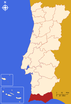
Country Portugal Region Algarve Historical province Algarve No. of municipalities 16 No. of parishes 84 Capital Faro Area – Total 4.960 km2 (1.9 sq mi) Population – Total 458.734 – Density 92.5/km2 (239.5/sq mi) No. of parliamentary representatives 9 Faro District (Portuguese pronunciation: [ˈfaɾu], Portuguese: Distrito de Faro) is the southernmost district of Portugal, coincident with the Algarve. The administrative centre, or capital, is the city of Faro.
Municipalities
The district is composed of 16 municipalities:
- Albufeira
- Alcoutim
- Aljezur
- Castro Marim
- Faro
- Lagoa
- Lagos
- Loulé
- Monchique
- Olhão
- Portimão
- São Brás de Alportel
- Silves
- Tavira
- Vila do Bispo
- Vila Real de Santo António
Summary of votes and seats won 1976-2011
Summary of election results from Faro district, 1976-2011 Parties % S % S % S % S % S % S % S % S % S % S % S % S % S 1976 1979 1980 1983 1985 1987 1991 1995 1999 2002 2005 2009 2011 PS 44.6 6 34.0 3 34.7 4 43.2 5 22.3 2 24.9 3 31.2 3 49.6 5 48.4 5 40.5 4 49.3 6 31.9 3 23.0 2 PSD 19.3 2 23.1 2 28.4 3 46.7 5 50.8 5 29.2 3 29.5 3 37.7 4 24.6 2 26.2 3 37.0 4 CDS-PP 6.8 7.4 6.1 3.1 2.8 8.3 7.3 8.3 5.8 10.7 1 12.7 1 PCP/APU/CDU 14.5 1 20.3 2 16.7 1 18.6 2 15.4 2 10.9 1 7.2 7.8 8.3 6.3 6.9 7.8 8.6 1 BE 2.3 2.8 7.7 15.3 1 8.2 1 AD 34.6 4 37.2 4 PRD 20.5 2 6.3 Source: Comissão Nacional de Eleições 
Districts and Autonomous regions of Portugal Districts 
Autonomous regions Categories:- Districts of Portugal
- Faro geography stubs

Wikimedia Foundation. 2010.