- Chamusca Municipality
-
Chamusca — Municipality — 
Flag
Coat of armsLocation in Portugal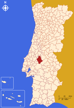
Coordinates: 39°21′N 8°29′W / 39.35°N 8.483°WCoordinates: 39°21′N 8°29′W / 39.35°N 8.483°W Country  Portugal
Region Ribatejo Subregion Lezíria do Tejo District/A.R. Santarém Government - Mayor Sérgio Carrinho (Unitarian Democratic Coalition) Area - Total 746.0 km2 (288 sq mi) Population - Total 11,313 - Density 15/km2 (38.8/sq mi) Parishes (no.) 7 Municipal holiday 5a Feira de Ascenção
date variesWebsite http://www.cm-chamusca.pt Chamusca (Portuguese pronunciation: [ʃɐˈmuʃkɐ]) is a municipality in Portugal with a total area of 746.0 km² and a total population of 11,313 inhabitants.
The municipality is composed of 7 parishes, and is located in Santarém District.
The present Mayor is Sérgio Carrinho, elected by the Unitarian Democratic Coalition.
The municipal holiday is Ascension Day.
Parishes
- Carregueira
- Chamusca
- Chouto
- Parreira
- Pinheiro Grande
- Ulme
- Vale de Cavalos
See also
External links
Abrantes · Alcanena · Almeirim · Alpiarça · Benavente · Cartaxo · Chamusca · Constância · Coruche · Entroncamento · Ferreira do Zêzere
Golegã · Mação · Ourém · Rio Maior · Salvaterra de Magos · Santarém · Sardoal · Tomar · Torres Novas · Vila Nova da Barquinha Categories:
- Municipalities of Portugal
- Towns in Portugal


Wikimedia Foundation. 2010.