- Devils River (Wisconsin)
-
This article is about the river in central and eastern Wisconsin. For a list of other rivers with a similar name, see Devils River.
Devils River Origin 6 miles (9.7 km) west of Denmark, Wisconsin Mouth West Twin River at the north end of Richard J. Drum Memorial Forest Progression East-southeast Basin countries United States Length 12 miles (19 km) Mouth elevation 650 feet (200 m) Basin area 176 square miles (460 km2) River system West Twin River The Devils River (also known archaically as the Manitoo River)[1] is a small 12-mile (19 km) long river in the state of Wisconsin in the United States.[2] Devils River flows primarily through Brown and Manitowoc counties,[2] and joins with the Neshota River to form the West Twin River.[3] It is part of the 176-square-mile (460 km2) West Twin River watershed.[3]
The Ojibwe name for the river is Ma-na-to-kik-e-we-se-be, or "Stooping Spirit River."[4] The root word "Ma-na-to" (or manitou) was often mistranslated as "devil" by early white settlers,[5] which is why the river carries the name it does today.[6]
Contents
Geology and ecology of the river
The river flows through agricultural land that drops a gentle 22.7 feet (6.9 m) per 1 mile (1.6 km).[2] However, the river does contains a series of three-ledge rapids near its mouth.[7][8]
The upper 8 miles (13 km) of the river have lower water flow than the lower 4 miles (6.4 km), and suffer from degraded habitat.[2] In the late summer and fall dry season, much of the upper two-thirds of the river dries out, leaving only unconnected pools.[2] Only on the lower third is sport fishing allowed.[2] Minnows are abundant throughout the river, and among those found in the Devils River are the blacknose dace, common creek chub, common shiner, longnose dace, northern redbelly dace, redside dace, white sucker, and various species of darter.[9] Sport fish such as black bullhead catfish and rock bass are native to the lower third.[2] The Wisconsin Department of Natural Resources stocks brown trout, northern pike, and rainbow trout in the river, but over-winter survival rates are very low.[2] The rusty crayfish, an invasive species, is now found in the Devils River.[10]
The Devils River is part of the West Twin River watershed. The West Twin River watershed is itself one of seven watersheds contributing to the Twin-Door-Kewaunee River Basin, which empties into Lake Michigan.[11]
History of the area
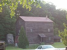 Rock Mill on Devils River.
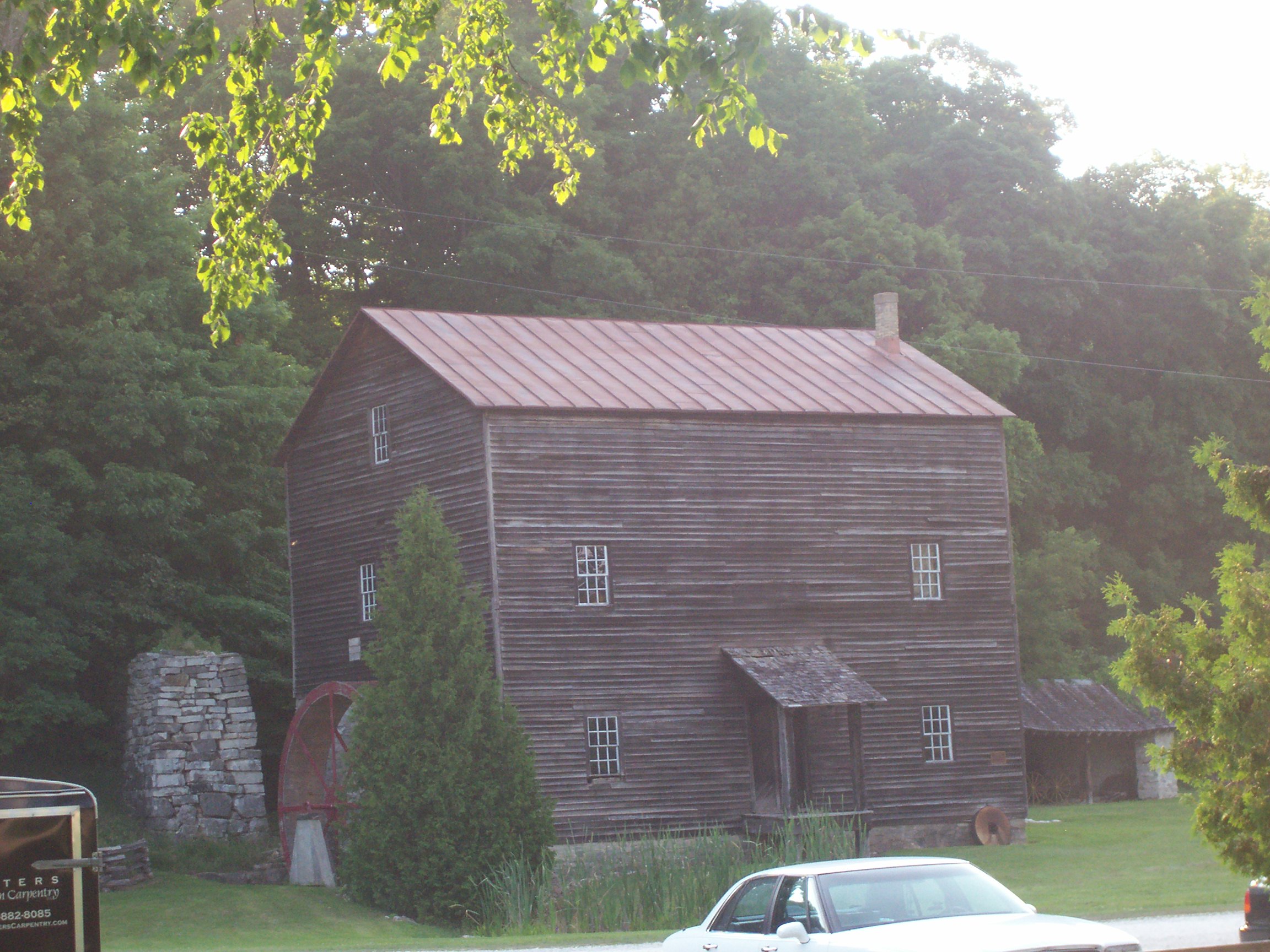
A major Native American trail used to cross the Devils River near Cherney Maribel Caves County Park in Brown County.[7] White settlers later used the same trail to access and travel across the country.[7] In 1840, United States Army Captain Thomas Jefferson Cram surveyed much of the area, and successfully proposed construction of a military road from Fort Dearborn (now the city of Chicago) to Fort Howard (now the city of Green Bay, Wisconsin).[7][12]
The Devils River played an important part in white settlement of Brown County.[7] When Brown County was first surveyed in 1820, the Devils River formed part of the boundary of the surveyed area.[13] Second Lieutenant Jefferson Davis (and future President of the Confederate States of America) was stationed at nearby Fort Winnebago from 1829 to 1831.[14] He went deer hunting on a boat on the Devils River, and nearly drowned before his companion saved him.[15] The town of Navarino was established on the river's banks in 1830.[16] During the Black Hawk War of 1832, the river formed one of the defensive boundaries of American forces in Brown County.[17] Some time in the early 1840s, it is alleged, Colonel Zachary Taylor (a future President of the United States) tried to cross the Devils River during a spring flood. The rushing water swept him off his horse, and he was rescued by his fellow soldiers.[7] In 1847, investor Pliney Pierce built Rock Mill on the Devils River, a site now listed on the National Register of Historic Places.[7][18] It is one of the oldest structures in Brown County.[7]
In 2005, the Central Brown County Water Authority proposed removing the remaining stone abutments of two bridges which formerly comprised the old military road in order to build a 65-mile (105 km) water pipeline across the county.[7] The Water Authority also proposed cutting a trench across the river in order to lay the pipeline beneath the riverbed.[7] Tunneling and directional boring were ruled out as prohibitively expensive.[7] The pipeline had to be built because water supplies needed by heavy residential development in the county were heavily depleted and highly contaminated.[7] The Water Authority changed the route of the proposed pipeline to avoid destruction of the stone bridge abutments, and the pipeline was constructed in 2006.[19] The $80 million pipeline opened in August 2007.[20]
Recreational activities on the Devils River
A state campground, the Devils River Campground, is located on the Devils River near Richard J. Drum Memorial Forest.[7]
A 14-mile (23 km) Devils River State Recreational Trail is being built alongside the river to provide recreational hiking and access to the river.[21] The trail will take hikers near the Devils River Crossing, a noted ford where railroad trestle bridges tower 100 feet (30 m) above the river.[21][22]
Footnotes
- ^ Lapham, Wisconsin: Its Geography and Topography, History, Geology, and Mineralogy, 1846, p. 93.
- ^ a b c d e f g h Wisconsin Department of Natural Resources, West Twin River Watershed, June 2010, p. 6.
- ^ a b Wisconsin Department of Natural Resources, West Twin River Watershed, June 2010, p. 4.
- ^ Calkins, "Indian Nomenclature of Northern Wisconsin, With a Sketch of the Manners and Customs of the Chippewa," in First Annual Report of the State Historical Society of Wisconsin, 1855, p. 120.
- ^ Vogel, Indian Names On Wisconsin's Map, 1991, p. 101.
- ^ Martin, History of Brown County, Wisconsin, Past and Present, 1913, p. 12.
- ^ a b c d e f g h i j k l m Hoeft, "Pipeline Runs Into History," Green Bay Press-Gazette, May 6, 2005.
- ^ Crawford, Walking Trails of Eastern and Central Wisconsin, 1997, p. 18.
- ^ Wisconsin Department of Natural Resources, West Twin River Watershed, June 2010, p. 5, 6.
- ^ Wisconsin Department of Natural Resources, West Twin River Watershed, June 2010, p. 9.
- ^ Wisconsin Department of Natural Resources, West Twin River Watershed, June 2010, p. 1.
- ^ Conzen, Chicago Mapmakers: Essays on the Rise of the City's Map Trade, 1984, p. 15.
- ^ Martin, History of Brown County, Wisconsin, Past and Present, 1913, p. 88.
- ^ Davis, Jefferson Davis, Ex-President of the Confederate States of America, 1890, p. 65.
- ^ Evans, "Military History of Green Bay," Proceedings of the State Historical Society of Wisconsin, 1900, p. 143; Martin, History of Brown County, Wisconsin, Past and Present, 1913, p. 143.
- ^ Martin, History of Brown County, Wisconsin, Past and Present, 1913, p. 117.
- ^ Martin, History of Brown County, Wisconsin, Past and Present, 1913, p. 128.
- ^ Shepard, Wisconsin's Best Breweries and Brewpubs: Searching for the Perfect Pint, 2001, p. 157.
- ^ Hoeft, "Authority Realigns Pipeline Route Near Devils River," Green Bay Press-Gazette, June 11, 2005; "Pipeline Work May Cause Traffic Headaches," Green Bay Press-Gazette, May 6, 2006.
- ^ Millard, "Brown County Cities Find Water Crisis Solution in Manitowoc County," Business Journal of Milwaukee, December 7, 2007.
- ^ a b "Denmark, Wisconsin." TravelWisconsin.com. No date. Accessed 2010-09-18.
- ^ "Devils River State Recreation Trail." Manitowoc County Planning and Park Commission. April 7, 2008. Accessed 2010-09-18.
Bibliography
- Calkins, Hiram. "Indian Nomenclature of Northern Wisconsin, With a Sketch of the Manners and Customs of the Chippewa." In First Annual Report of the State Historical Society of Wisconsin. Madison, Wisc.: Beriah Brown, 1855.
- Conzen, Michael P. Chicago Mapmakers: Essays on the Rise of the City's Map Trade. Chicago: Chicago Historical Society, 1984.
- Crawford, Bob. Walking Trails of Eastern and Central Wisconsin. Madison, Wisc.: University of Wisconsin Press, 1997.
- Davis, Varina. Jefferson Davis, Ex-President of the Confederate States of America. New York: Belford Company, 1890.
- Hoeft, Mike. "Authority Realigns Pipeline Route Near Devils River." Green Bay Press-Gazette. June 11, 2005.
- Hoeft, Mike. "Pipeline Runs Into History." Green Bay Press-Gazette. May 6, 2005.
- Lapham, Increase Allen. Wisconsin: Its Geography and Topography, History, Geology, and Mineralogy. New York: Paine & Burgess, 1846.
- Martin, Deborah Beaumont. History of Brown County, Wisconsin, Past and Present. Chicago: S.J. Clarke Pub. Co., 1913.
- Millard, Pete. "Brown County Cities Find Water Crisis Solution in Manitowoc County." Business Journal of Milwaukee. December 7, 2007.
- "Pipeline Work May Cause Traffic Headaches." Green Bay Press-Gazette. May 6, 2006.
- Shepard, Robin. Wisconsin's Best Breweries and Brewpubs: Searching for the Perfect Pint. Madison, Wisc.: University of Wisconsin Press, 2001.
- Vogel, Virgil J. Indian Names On Wisconsin's Map. Madison, Wisc.: University of Wisconsin Press, 1991.
- Evans, William L. "Military History of Green Bay." Proceedings of the State Historical Society of Wisconsin. Madison, Wisc.: Democrat Printing Co., 1900
- Wisconsin Department of Natural Resources. West Twin River Watershed. Madison, Wisc.: Wisconsin Department of Natural Resources, June 2010.
Categories:- Rivers of Wisconsin
- Geography of Brown County, Wisconsin
- Geography of Manitowoc County, Wisconsin
Wikimedia Foundation. 2010.