- De Tour Passage Underwater Preserve
-
DeTour Passage Underwater Preserve Location within the state of Michigan
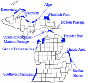
Location Lake Huron, Chippewa County, Michigan USA Nearest city De Tour Village, Michigan Coordinates 45°59′06″N 83°53′42″W / 45.985°N 83.895°WCoordinates: 45°59′06″N 83°53′42″W / 45.985°N 83.895°W Governing body Michigan Department of Natural Resources The DeTour Passage Underwater Preserve is a preservation area in the U.S. state of Michigan. Located in Lake Huron, it completely surrounds Drummond Island and includes all of DeTour Passage and adjacent sections of Lake Huron and the St. Mary's River.[1]
History
With the discovery of significant hematite mines in northern Minnesota in the late 19th century, and the construction of steel mills from the late 19th century onward in and around Cleveland, Ohio, Detroit, Michigan, and Gary, Indiana, the DeTour Passage became an essential element in one of the most significant commodity supply pipelines of the Great Lakes.
The DeTour Passage carries almost all of the commercial water traffic that is entering or leaving Lake Superior. In addition, quarries on Drummond Island are a rich source of commercial dolomite limestone and aggregates, and many vessels have called upon Drummond Island to pick up stone cargoes. For these reasons, the DeTour Passage Underwater Preserve is exceptionally rich in Lake freighter wrecks of all kinds.
A historic lighthouse, the DeTour Reef Light, today protects continuing freight traffic through this waterway.
See also
References
- ^ "DeTour Passage Underwater Preserve". Michigan Underwater Preserve Council. http://www.michiganpreserves.org/detour.htm. Retrieved 2009-05-06.
Great Lakes of North America Main lakes 
Secondary lakes Waterways Detroit River • Erie Canal • French River • Great Lakes Waterway • Niagara River • Nipigon River • St. Clair River • Saint Lawrence River • Saint Lawrence Seaway • St. Marys River • Soo Locks • Straits of Mackinac • Trent–Severn Waterway • Welland CanalLists of islands Historic geology Lakeshores Related topics Basin • Bays of the Great Lakes • Great Lakes region • Georgian Bay • Great Lake ships • Isle Royale • Lake effect • Manitoulin Island • Megalopolis • Quebec City – Windsor Corridor • Settlements • Shipwrecks • Tall shipsCategories:- Protected areas of Chippewa County, Michigan
- Marine parks of Michigan

Wikimedia Foundation. 2010.