- Streets in Oslo
-
This is a list of the Streets in Oslo, Norway.
Contents
Aasta Hansteens vei
Aasta Hansteens vei Postal code: 0301 Addresses: 1A-10 Location: Stovner, Oslo Construction Inauguration: 1977 Aasta Hansteens vei (1A-3, 2-10) lies in Stovner,[1] Oslo. The road is a cul-de-sac from Fossumveien to Stovner police station. The street was named in 1977 after the women's rights pioneer and artist Aasta Hansteen (born 10 September 1824, died 1908).[2]
Abbediengen terrasse
Abbediengen terrasse Postal code: 0301 Addresses: 1A-4 Location: Ullern, Oslo Construction Inauguration: 1935 Abbediengen terrasse (1A-3,2-4) is a cul-de-sac in the suburb of Ullern,[3] Oslo. The street runs northwards from the crossroads of Harbitzalléen/Abbedikollen. The street got its name in 1935 after the farm of Abbediengen.[2]
Abbediengveien
Abbediengveien Postal code: 0301 Addresses: 1-21 Location: Ullern, Oslo Construction Inauguration: 1917 Abbediengveien (1-21, 2-8) is a street in the suburb of Ullern,[4] Oslo. The street runs from St. Edmunds vei to Harbitzalléen. The streets took its name in 1917[2] after the farm Abbediengen.
Aasmund Vinjes vei
Aasmund Vinjes vei Postal code: 0301 Addresses: 25-43 Location: Vinderen, Vestre Aker, Oslo Construction Inauguration: 1917 Aasmund Vinjes vei (25-43, 26-40) is a road in Vinderen,[3] Oslo. The road is a villa road which runs from Rasmus Winderens vei to Slemdalsveien and Gaustad station. At the bottom of the road is a trail. The road was named after the author Aasmund Olavsson Vinje (born 1818, died 1870) in 1917.[2]
Damstredet
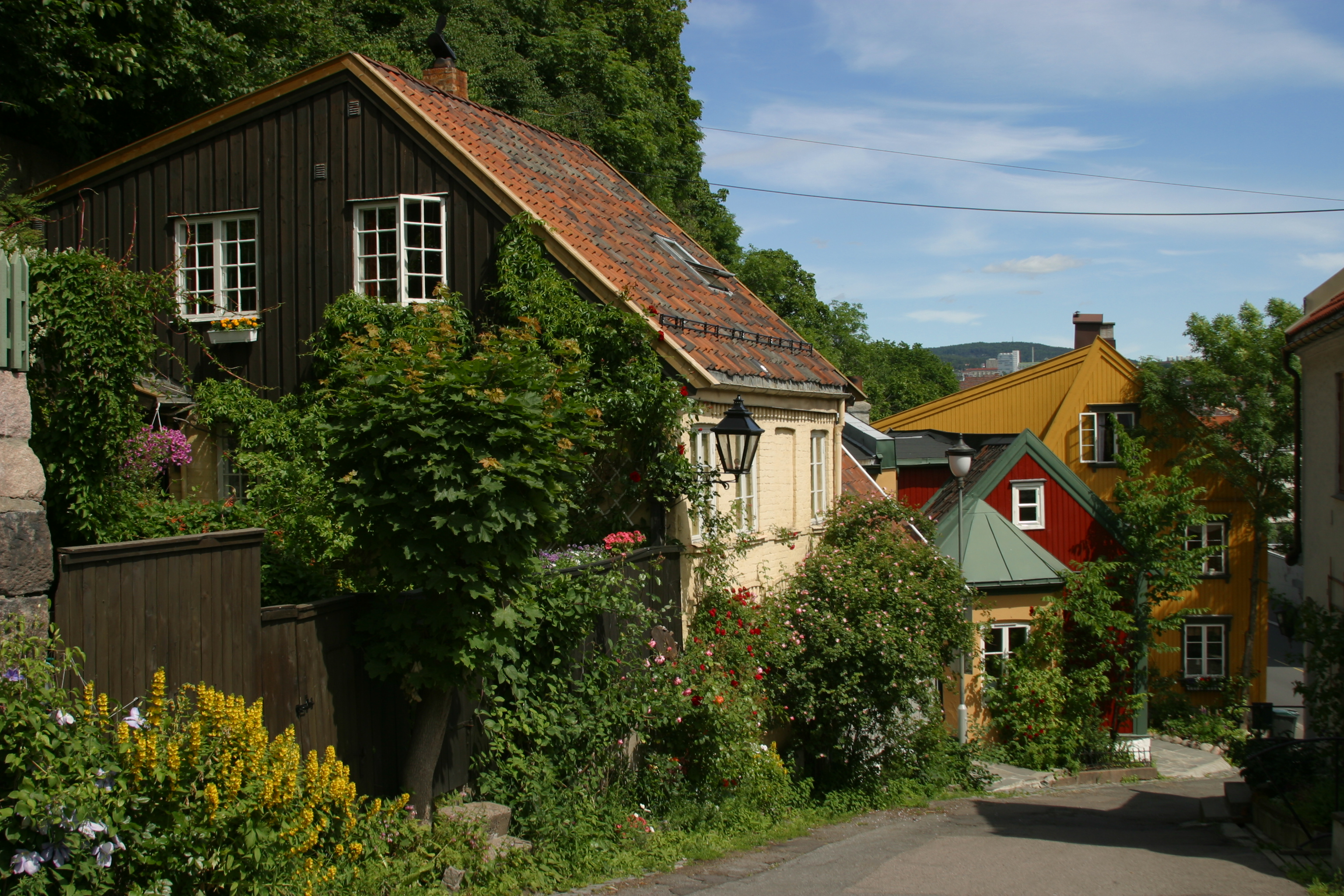
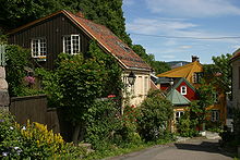 Section of Damstredet.
Damstredet is a small and narrow street, located in Oslo, in the borough of St. Hanshaugen. Damstredet has managed to survive intact as a charming part of town, with well-preserved and inhabited wooden houses, now one of the few streets that retains the then small town character of Oslo in a genuine manner.
Damstredet was mostly built from 1810 to 1860, as part of the expansion of Oslo that begun at this time. The first house, Solberg, was erected in 1756 by sculptor Ole Meyer. His nephew, sculptor Andreas Hansen Meyer, took over in 1767, while his son Ole, also sculptor, erected another building in 1838. His friend, author and poet Henrik Wergeland, then newly wed, moved in and spent two of his most productive years here, until moving to Grotten in 1841. Solberg was later home of architect Heinrich Ernst Schirmer, and General and Minister of Defence (1868–1872) Nils Christian Irgens.
External links
59°55′11.77″N 10°44′50.16″E / 59.9199361°N 10.7472667°E
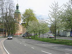
Geitmyrsveien
 Geitmyrsveien at Lindern
Geitmyrsveien (1-75, 20-76[5]) is a street in Oslo situated in the borough of St. Hanshaugen.
The street is c. 1.6 km long. It runs from Ullevålsveien along St. Hanshaugen park (1-33), and north of the park it separates the neighbourhoods of Lovisenberg and Valleløkken (34-54/63A), and later between Lindern and Lovisenberg until it meets Kirkeveien/Griffenfeldts gate (Oslo Ring Road 2) where it ends.
 Frølichbyen, Geitmyrsveien 44-48.
The habitation in Geitmyrsveien along the park consists of townhouses and finer villas. Number 33 is the farmstead "Nicolailøkken" with a farmhouse in Swiss style built in 1836 with a surviving yard and buildings. Number 44-48 belong to "Frølichbyen". In number 69-71 resides the Odontological Faculty of the University of Oslo, and in number 75 the National Public Health Institute.
From 1879 the street has had its name from Gjetemyren farm in Tåsenveien 2. Today the area with allotment gardens between Griffenfeldts gate (as it crosses Geitmyrsveien), Uelands gate and Kierschows gate is called "Geitmyra".
Bus line 37 (Helsfyr – Nydalen) goes along Geitmyrsveien between Colletts gate and Kirkeveien. From 1899 there was also a tram line (from Sagene to Akersgata, later Sagene Ring) in Geitmyrsveien between Colletts gate and Kirkeveien. The tram line was closed in 1961.
External links
- Shops, restaurants, photos and architecture from the areas Geitmyrsveien passes through.
- Map of the street and area.
Heierstuveien
Heierstuveien (1-27, 2(A)-42) is a street in the Norwegian capital Oslo[6] Heierstuveien is located in the borough of Nordre Aker, more specifically on the outskirts of the residential area Korsvoll.
Heierstuveien is approximately 285 metres long, and runs from the street Taasenveien to the street Carl Kjeldsens vei.
External links
Map of the street and its surroundings
Karl Johans gate
Main article: Karl Johans gateKarl Johans gate (Karl Johan Street), named after King Karl Johan, is the main street of the city of Oslo. In its current route, it connects the main railroad station in Oslo and the Royal Palace, changing slightly its direction and width halfway between them, at Egertorget.
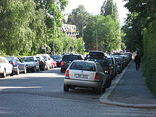
Niels Juels Gate
Niels Juels Gate (1A-51, 2-70B) is a street in the Frogner district of Oslo in Norway.
The street was built in 1879 and was named after the admiral Niels Juel (1629–97).
Streets in the vicinity include Svoldergata, Drammensveien, Bygdøy allé, Colbjørnsens gate, Gyldenløves gate and Briskebyveien
In 1932 the Indian embassy was built on the street and was designed by Gudolf Blakstad and Herman Munthe-Kaas.[7]
 Niels Juels gate towards Drammensveien
Norwegian National Road 161
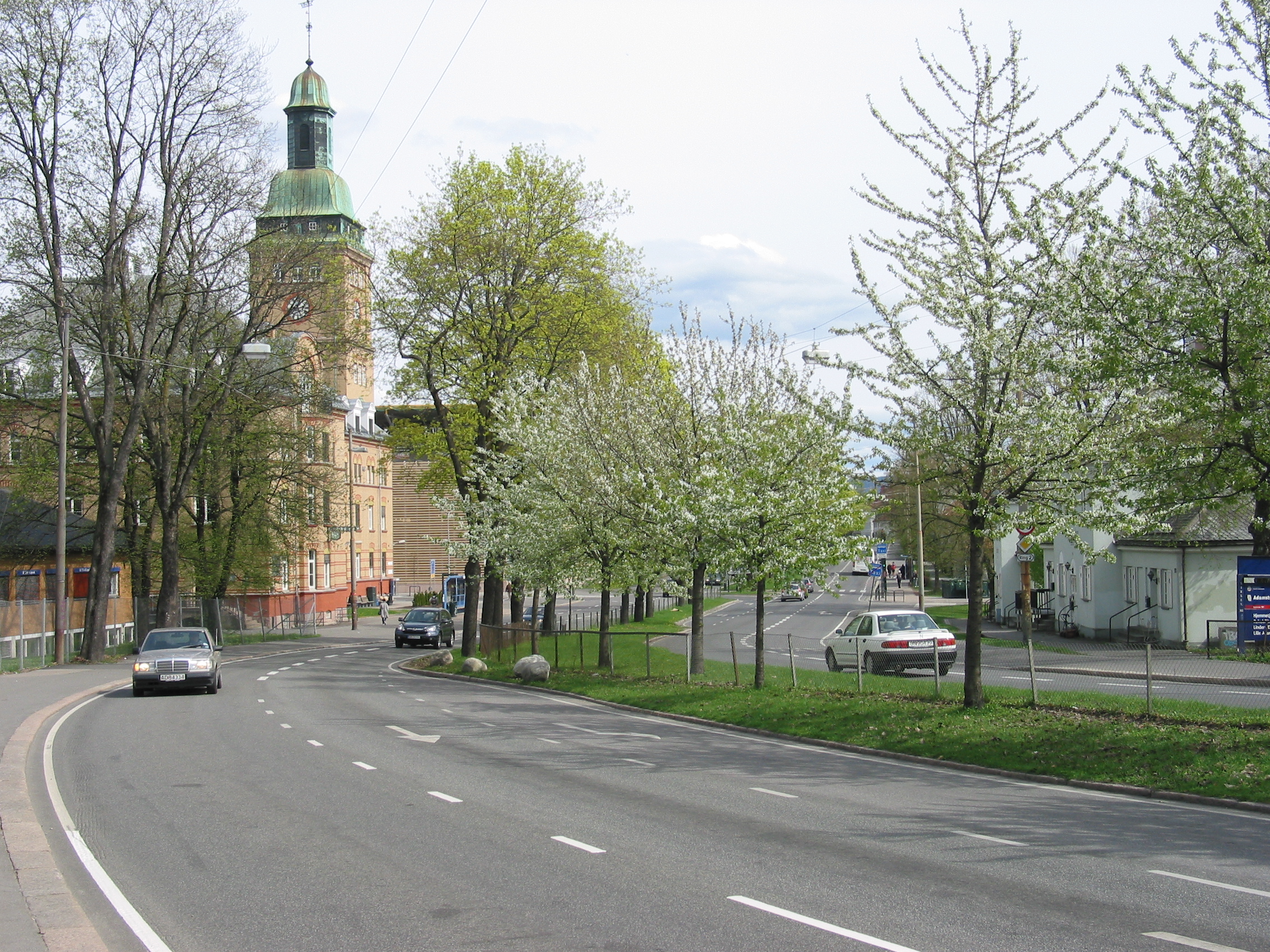
 Portion of Norwegian National Road 161 (Kirkeveien) near Ullevål University Hospital.
Norwegian National Road 161 (Norwegian: Riksvei 161, also referred to as Ring 2 or "Kirkeveiringen") is an important ring road and surface street through densely populated parts of Oslo, Norway. The entire route is signposted as Ring 2, not National Road 161.
It stretches from Skøyen to Lodalen, a length of 9.7 km. The most important locations along the route are Skøyen, Frogner, Majorstuen, Lindern, Sagene, Carl Berners Plass, Tøyen and Galgeberg. Important institutions like the Frogner Park, the Norwegian Broadcasting Corporation, Ullevål University Hospital and the University of Oslo are situated along or near the road. The name of streets are Drammensveien—Halvdan Svartes gate—Kirkeveien—Griffenfeldts gate—Marcus Thranes gate—Christian Michelsens gate—Finnmarkgaten—Kjølberggaten—Åkebergveien—St. Halvards gate—Kværnerveien.
Traffic
Ring 2 is used by both cars and public transportation. The traffic on the route is separated only with traffic lights and roundabouts. The road is connected to major highways such as European route E18, National Road 4 and National Road 190. Major parts of Ring 2 are heavily congested during peak hours, because of low capacity and many large intersections. The route was originally planned to have 4 lanes, but several parts have only 2 lanes. The entire route is a priority road and the speed limit is 50 km/h.
There are some parking garages situated on the western parts of the route. The gas stations along the road are situated on Skøyen, Marienlyst, Fagerborg, Lindern, Carl Berners Plass and Tøyen.
Ring 3 (Oslo)
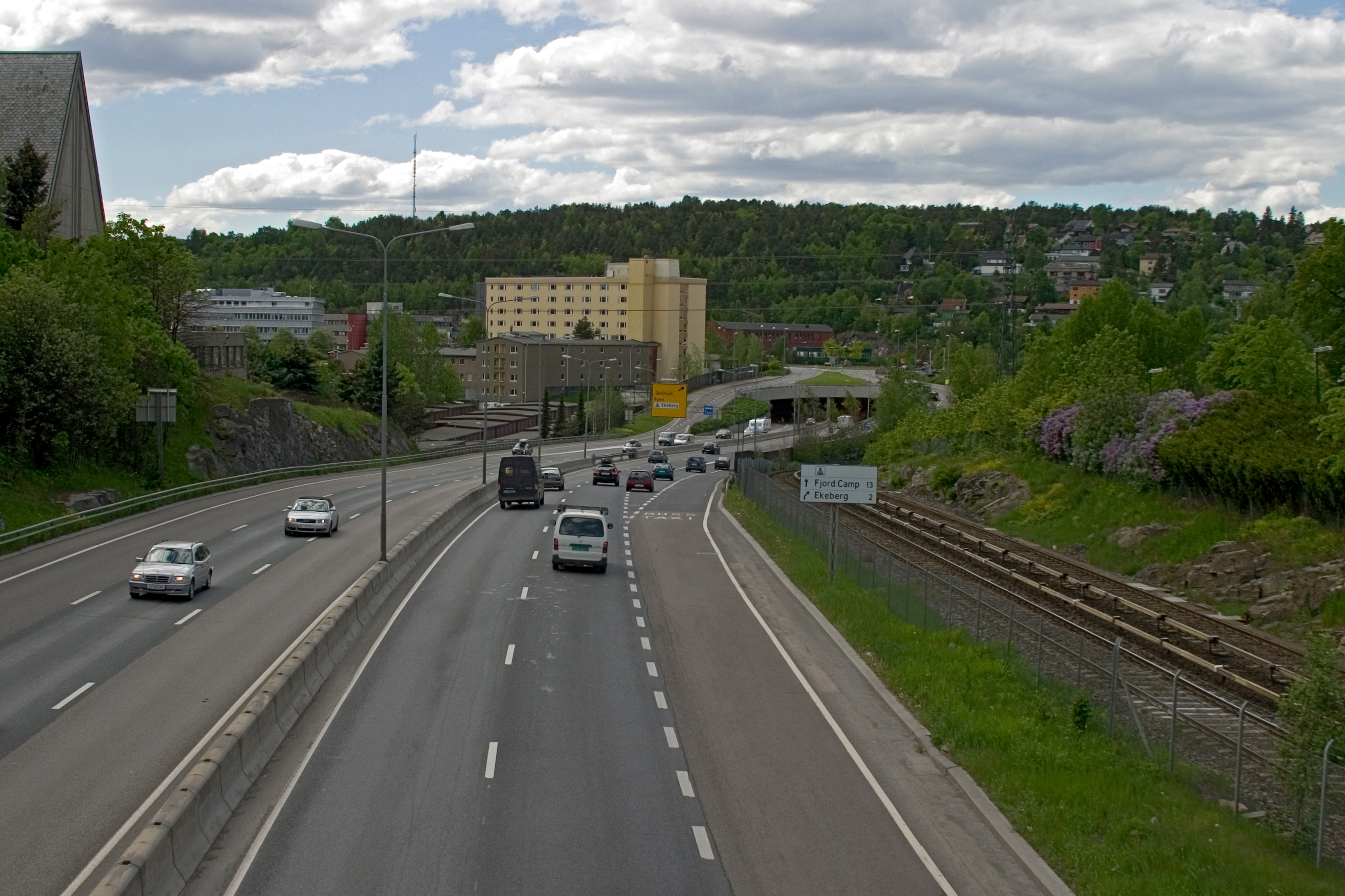
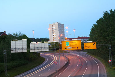 Ring 3 at Teisen
The Ring 3 or Norwegian national road 150 (formerly known as Store Ringvei) is a major highway in Oslo, Norway. The numerous pre-existing roads orbiting the most densely populated areas of Oslo now have become a beltway limited-access road from its starting point at Ryen, through the Sinsen Interchange, and to Lysaker in Bærum.
The Sinsen interchange, where Ring 3 meets Trondheimsveien was opened in 1962. The increase in traffic was greater than the capacity of the junction, and thus a bridge was constructed that redirected Trondheimsveien above the roundabout.
Further restructuring was done in 1992, when a local tramway line was redirected outside of the interchange, and in 1994, when Riksvei 150 was directed below the roundabout. The Norwegian Public Roads Administration plans to connect the Løren tunnel, a planned tunnel over Riksvei 150, with the Sinsen interchange in late 2008.[8]
The highway is subdivided into parts with separate names (from Ryen to Lysaker):
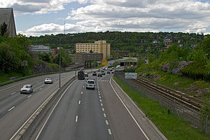 The Adolf Hedins vei is part of Ring 3, here with Manglerud to the left and Ryen up ahead
- Adolf Hedins vei
- Hjalmar Brantings vei
- Dag Hammarskjølds vei
- Storoveien
- Rolf Wickstrøms vei
- Tåsen Tunnel
- Kaj Munks vei
- Torgny Segerstedts vei
- Viggo Hansteens vei
- Ullernchausséen
- Granfoss Tunnel (Snarøyveien).
- External links
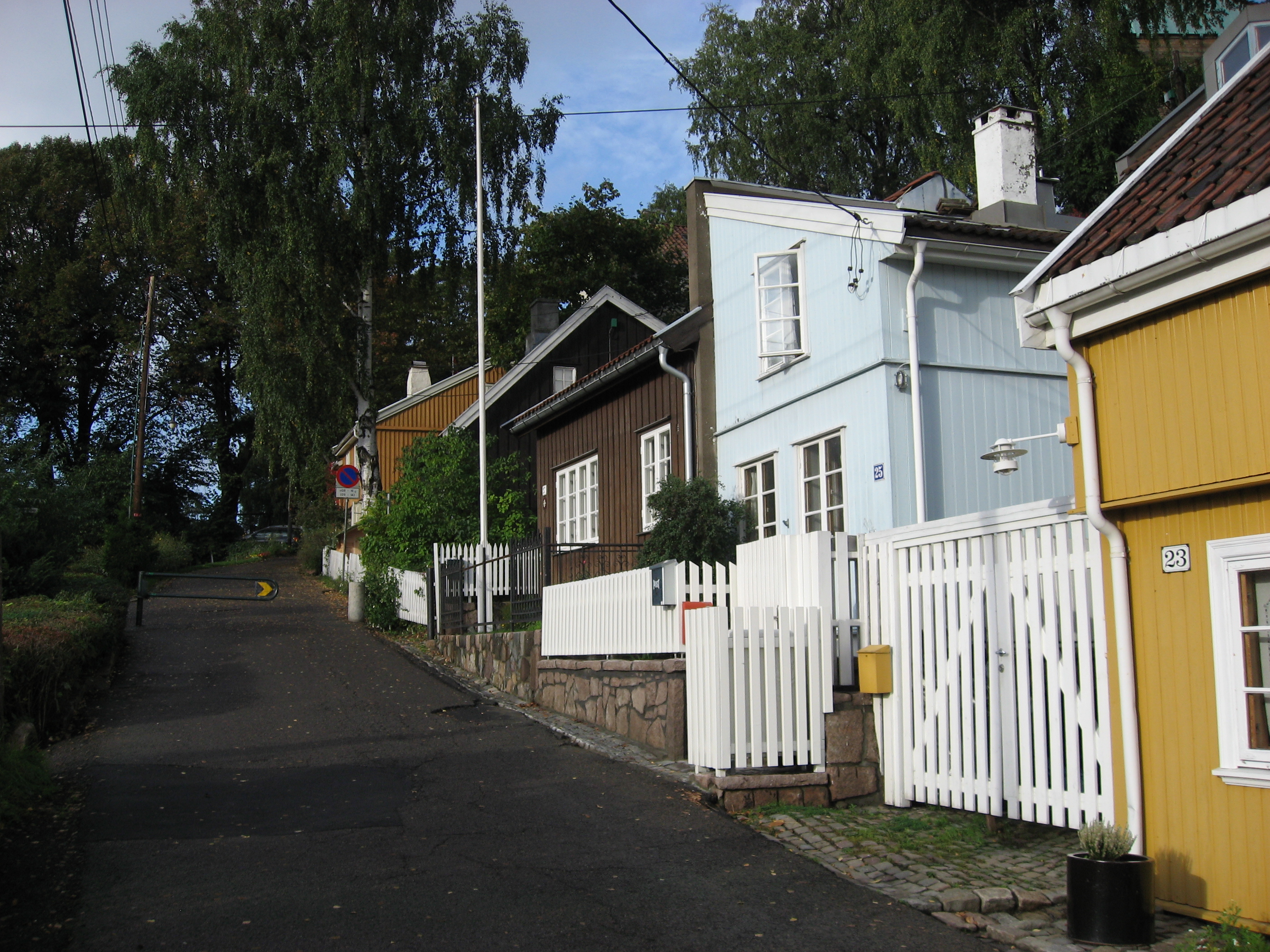
Telthusbakken

Telthusbakken is a narrow street located in Oslo, in the borough of St. Hanshaugen. Almost all buildings along the street are old and traditional wooden houses, many from the period around 1815 when deeds were issued for the properties.
During the 16th century, the street which is now Telthusbakken was part of the main road passing the Old Aker Church, from east to west of Oslo and further across to the west coast. Sitting on top of the Telthusbakken hill, Old Aker Church was built around 1080 and is the oldest building still in use in Oslo. The name Telthusbakken is from a large canvas house that existed around 1700.
The street is mentioned in the song "Glemte minner" on the album Neste sommer by the Norwegian band deLillos.
See also
Remember to visit em all
External links
- Description on VisitNorway.com
- Description on Yahoo! Travel Guide
59°55′24.68″N 10°44′57.16″E / 59.9235222°N 10.7492111°E
Aagots vei
Aagots vei Postal code: 0301 Addresses: 1A-20B Location: Oppsal, Østensjø, Oslo Construction Inauguration: 25 September 1975 Aagots vei (1A-19, 2A-20B) lies in Oppsal in the suburb of Østensjø[3] in Oslo. The road is a crescent off Oppsalveien without crossing any other streets.[2] The road is named after Aagot Tveter (1883–1972), who was the daughter of the former mayor of Aker, Haakon Tveter. From 1936, she was one of the owners of Østensjø gård. The street was named on 25 September 1975.
References
- ^ Oslo municipality – Street names. Oslo.
- ^ a b c d e Oslo byleksikon. ISBN 82-573-0815-3.
- ^ a b c Oslo municipality – Street names. Oslo.
- ^ Oslo municipality – Street name. Oslo. Besøkt 11 September 2006.
- ^ "Oslo kommune – Gatenavn". Oslo municipality. http://www.oslo.kommune.no/dok/felles/div/bydeler/nye/alfabetisk/adresseoversikt.asp. Retrieved 2008-03-18.
- ^ Oslo Municipality – Streets, entered 21 November 2009.
- ^ Norsk Kunstnerleksikon s. 249
- ^ "Sinsenkrysset" (in Norwegian). Norwegian Public Roads Administration. http://www.vegvesen.no/region_ost/prosjekter/nyulven_sinsen/sinsenkrysset.stm. Retrieved 2007-12-28.
Literature
- Svensgam, Arild: De er døde – men lever fortsatt i Oslo. Galehuset forlag, 1999.
Categories:


Wikimedia Foundation. 2010.