- Căușeni District
-
Căuşeni — District (Raion) — 
Coat of arms
Country  Republic of Moldova
Administrative center
(Oraş-reşedinţă)
 Căuşeni
Government - Raion President Ilie Gluh (PDM), since 2011 Area - Total 1,163 km2 (449 sq mi) Population (2011) - Total 92,300 - Density 79.3/km2 (205.4/sq mi) Time zone EET (UTC+2) - Summer (DST) EEST (UTC+3) Postal Code 243 Area code(s) +373 43 Car plates CS Website www.causeni.md Căuşeni is a district (Moldovan: raion) in the central part of Moldova, with the administrative center at Căuşeni. The other major city is Căinari. As of January 1, 2011, its population was 92,300.
Contents
History
Location of the earliest documentary attestation, the district is Căuşeni, first attested in 1455. Other localities with the earliest documentary attestation are: Zaim, Cîrnăţeni, Fîrlădeni, localities approved for the first time in the period 1535-1573. In the 16th-18th centuries, develop intense agriculture, an important wine-making industries and population growth attests. In 1761 is built in Căuşeni city, Assumption Church, inside painted frescoes on the walls. In 1812, after the Russo-Turkish War (1806-1812), is the occupation of Basarabia, Russian Empire during this period (1812-1917), there is an intense russification of the native population. In 1918 after the collapse of the Russian Empire, Bessarabia united with Romania in this period (1918-1940, 1941-1944), the district is part of the Tighina County. In 1940 after Molotov-Ribbentrop Treaty, Basarabia is occupied by the USSR. In 1991 as a result of the proclamation of Independence of Moldova, part and residence of the Tighina County (1991-2003), and in 2003 became administrative unit of Moldova.
Geography
Causeni district is located in the southern part of Moldova. Neighborhood has the following districts: Ialoveni and Anenii Noi in the north, east Slobozia District, Ştefan Vodă District in south-east, border state in southern with Ukraine, Cimişlia District in west. Relief is both flat, poorly fragmented, with maximum altitudes of 220-230 m. The minimum altitude 20-30 m in the Lower Nistru plain. Erosion processes with a low intensity.
Climate
Temperate continental climate with an annual average district temperature +10.5+11 c. July average temperature +22+23 C, of January -4 C. Annual precipitation 450-550 mm. Average wind speed 2-5 m \ s.
Fauna
Typical European fauna, with the presence of such mammals such as foxes, hedgehogs, deer, wild boar, polecat, wild cat, ermine and others. Of birds: partridges, crows, eagles, starling, swallow and more.
Flora
Forests of the district are complemented by tree species such as oak, ash, hornbeam, linden, maple, walnut and others. From plants: wormwood, denial, knotweed, fescue, nettle and many others.
Rivers
Causeni district is located in the Nistru river basin, its main tributary of the district territory is Botna river (152 km). Most lakes are artificial origin.
Administrative subdivisions
Demographics
 Hagimus (population: 2731)
1 January 2011 the district population was 92,300 of which 26.9% urban and 73.1% rural population
- Births (2010): 1088 (11.8 per 1000)
- Deaths (2010): 1199 (13.0 per 1000)
- Growth rate (2010): -111 (-1.2 per 1000)
Ethnic groups
Ethnic group Population % of total* Moldovans (Romanians) 82,276 90.80% Russians 3,839 4.24% Ukrainians 2,469 2.72% Bulgarians 1,108 1.22% Gagauzians 653 0.72% Others 267 0.29% Religion
- Christians - 98.5%
- Orthodox Christians - 97.1%
- Protestant - 1.4%
- Baptists - 0.7%
- Pentecostal - 0.5%
- Seventh-day Adventists - 0.1%
- Evangelicals - 0.1%
- Other 0.9%
- No Religion 0.6%
Economy
Main branches of the district are agriculture and manufacturing. District economy is currently 15 721 registered companies. Manufacturing and agriculture are the dominant industries in the district economy, which decisively depend on revenues and ensuring socio-economic progress. The structure of the major industry of the district share is manufacturing (wine-making, processing of milk, bakery products), industry based on local raw material. Agricultural land is 93,700 ha (80.5%) of total land area. Arable land occupies 70 600 ha (60.7%) of the total agricultural land: planting of orchards - 4.300 ha (3.7%), vineyards - 5.200 ha (4.5%).
Education
The district operates 69 educational institutions, including institutions of secondary education - 37 (14,960 students), kindergartens - 31 (3014 children), a creative center for children.
Politics
Causeni district granted priority mainly right-wing parties. In Moldova represented by the AEI. PCRM is a continuous fall in percentage the last three elections.
During the last three elections AEI had an increase of 80.2%
Parliament elections results Year AEI PCRM 2010 51.58% 20,140 41.19% 16,082 July 2009 50.27% 19,629 44.26% 17,281 April 2009 30.03% 11,179 53.01% 19,733 Elections
Summary of 28 November 2010 Parliament of Moldova election results in Causeni District Parties and coalitions Votes % +/− Party of Communists of the Republic of Moldova 16,082 41.19 −3.07 Liberal Democratic Party of Moldova 12,525 32.08 +19.62 Democratic Party of Moldova 4,725 12,10 +3.13 Liberal Party 2,515 6.44 −5.68 European Action Movement 835 2.14 +2.14 United Moldova 437 1.12 +1.12 Other Party 1,538 3.91 -18.34 Total (turnout 57.46%) 39,352 100.00 Culture
The district works: 37 houses of culture, folk bands with Title 31 model, 74 amateur artistic groups with a total of 1200 participants. School of Arts in Căuşeni city, school of Music in Căinari, school of Music in Copanca, museum of history and ethnography of Căuşeni, House-Museum "Alexei Mateevici" in Zaim, House-Museum "Alexei Mateevici" from Cainari, Museum of history and ethnography of the village Copanca, public Libraries 45, including 9 branches for children].
Health
In district works: a hospital with 292 beds general fund, 19 MFI, 13 health centers, five health points, 13 clinical-diagnostic laboratories.
Tourism
 Assumption of Our Lady Church
- Nativity Church, Căuşeni
- Trajan's Wall in villages Copanca and Chircăieşti
Referncies
- Căuşeni District Council
- District population per year
- Discuție:Raionul Căușeni
- Rezultatele alegerilor din 28 noiembrie 2010 în raionul Căuşeni
Coordinates: 46°55′N 29°15′E / 46.917°N 29.25°E
Cities 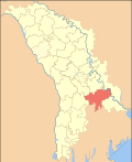
Communes Baccealia | Baimaclia | Chircăiești | Chircăieştii Noi | Chiţcani | Ciufleşti | Cîrnăţeni | Cîrnăţenii Noi | Copanca | Coşcalia | Cremenciug | Fîrlădeni | Gîsca | Grădiniţa | Grigorievca | Hagimus | Opaci | Pervomaisc | Plop-Ştiubei | Săiţi | Sălcuţa | Taraclia | Tănătari | Tănătarii Noi | Tocuz | Ucrainca | Ursoaia | Zaim
Villages
of sub-city or
sub-commune levelCăinari, loc.st.cf | Tricolici | Surchiceni | Baurci | Mereneşti | Zahorna | Sălcuţa Nouă | Florica | Plop | Fîrlădenii Noi | Leuntea | Valea Verde | Constantinovca | Ştefăneşti | Ursoaia Nouă | Zviozdocica | Marianca de Sus | Zaim, loc. st. c. f.
Administrative divisions of MoldovaDistricts Anenii Noi · Basarabeasca · Briceni · Cahul · Cantemir · Călăraşi · Căuşeni · Cimişlia · Criuleni · Donduşeni · Drochia · Dubăsari · Edineţ · Făleşti · Floreşti · Glodeni · Hînceşti · Ialoveni · Leova · Nisporeni · Ocniţa · Orhei · Rezina · Rîşcani · Sîngerei · Soroca · Străşeni · Şoldăneşti · Ştefan Vodă · Taraclia · Teleneşti · Ungheni
Autonomous regions Municipalities 1 The political status of Transnistria is not settled. Categories:- Căuşeni District
- Districts of Moldova


Wikimedia Foundation. 2010.