- Caerphilly County Borough
-
Coordinates: 51°39′22″N 3°10′59″W / 51.656°N 3.183°W
Caerphilly County Borough
Bwrdeistref Sirol Caerffili
Geography Area
- Total
- % WaterRanked 18th
278 km²
0 %Admin HQ Hengoed ISO 3166-2 GB-CAY ONS code 00PK Demographics Population:
- Total (2010 est.)
- Density
Ranked 5th
173,100
Ranked 5th
623 / km²Ethnicity 98.8% White. Welsh language
- Any skillsRanked 17th
16.8%Politics 
Caerphilly County Borough Council
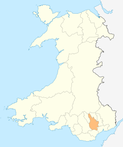
http://www.caerphilly.gov.uk/Control NOC (Plaid minority administration) MPs Caerphilly (Welsh: Caerffili) is a county borough in southern Wales, straddling the ancient county boundary between Glamorgan and Monmouthshire.
Its main town is Caerphilly, and also the largest. Other towns in the county borough are Bedwas, Risca, Ystrad Mynach, Newbridge, Blackwood, Bargoed, New Tredegar and Rhymney.
Contents
History
The county borough was formed on 1 April 1996 by the merger of the Rhymney Valley district of Mid Glamorgan with the Islwyn borough of Gwent.
Government
The region is governed by Caerphilly County Borough Council.
Schools
Secondary schools in Caerphilly County Borough:
- Bedwas High School, Bedwas
- Blackwood Comprehensive School, Blackwood
- Cwmcarn High School, Cwmcarn
- Heolddu Comprehensive School, Bargoed
- Lewis Girls Comprehensive School, Hengoed
- Lewis School Pengam, Bargoed
- Newbridge Comprehensive School, Newbridge
- Oakdale Comprehensive School, Oakdale
- Pontllanfraith Comprehensive School, Pontllanfraith
- Rhymney Comprehensive School, Rhymney
- Risca Community Comprehensive School, Risca
- St. Martin's Comprehensive School, Caerphilly
- St. Cennydd Comprehensive School, Caerphilly
- Ysgol Gyfun Cwm Rhymni, Blackwood (Welsh language)
See also
- List of places in Caerphilly County Borough for a list of towns and villages
External links
- Caerphilly Council official website
- Caerphilly County Borough at the Open Directory Project
- Menter Iaith Sir Caerffili the Welsh Language Initiative for Caerphilly County Borough
- Visit Caerphilly Tourism site by the local authority
- Caerphilly Net News site for the borough
Principal areas of Wales Anglesey • Blaenau Gwent • Bridgend • Caerphilly • Cardiff • Carmarthenshire • Ceredigion • Conwy • Denbighshire • Flintshire • Gwynedd • Merthyr Tydfil • Monmouthshire • Neath Port Talbot • Newport • Pembrokeshire • Powys • Rhondda Cynon Taf • Swansea • Torfaen • Vale of Glamorgan • Wrexham
Caerphilly County Borough Principal settlements Aberbargoed · Abercarn · Bargoed · Bedwas · Blackwood · Caerphilly · Crumlin · Gelligaer · Newbridge · Rhymney · Risca · Senghenydd · Ystrad Mynach
Towns and villages Abertridwr, Caerphilly · Abertysswg · Argoed · Blaen-carno · Bont Pren · Britannia · Brithdir · Bryn · Bryncenydd · Bute Town · Caledfryn · Castle Park · Cefn Fforest · Cefn Hengoed · Cefn Mably · Chapel of Ease · Churchill Park · Croespenmaen · Crosskeys · Cwmbargoed · Cwmcarn · Cwmgelli · Cwmfelinfach · Cwmsyfiog · Cwmnantygwynt · Darran Valley · Deri · Draethen · Eglwysilan · Elliotstown · Energleyn · Fernlea · Fleur de Lys · Fochriw · Gellihaf · Gelligroes · Gilfach · Gilfach Estate · Glan-y-nant · Graig-y-Rhacca · Groesfaen · Hafodyrynys · Hendredenny · Hengoed · Hollybush · Lansbury Park · Llanbradach · Llanfabon · Llanfach · Llechryd · Llwyn Gwyn · Machen · Maesycwmmer · Manmoel · Markham · Mornington Meadows · Mynyddislwyn · Nelson · New Tredegar · Oakdale · Ochrwyth · Pantside · Pantyresk · Penallta · Pengam · Penllwyn · Penmaen · Penpedairheol · Pentwyn (near Fochriw) · Pentwyn (near Penyrheol) · Pentwyn (near Trinant) · Pentwynmawr · Penybryn · Penyfan · Penyrheol · Phillipstown · Pontllanfraith · Pontlottyn · Pontymister · Pontywaun · Princetown · Pwllypant · Rhymney Bridge · Rudry · Ruperra · Springfield · Tirphil · Tir-y-berth · Trecenydd · Tredomen · Treowen · Trethomas · Trinant · Troedrhiwfwch · Ty Sign · Van · Waterloo · Watford · Wattsville · West End · Wernddu · Woodfieldside · Wyllie · YnysdduCategories:- Caerphilly County Borough
- Counties of Wales
- Glamorgan
- Principal areas of Wales
- Gwent geography stubs
Wikimedia Foundation. 2010.
