- St Catherine's Church, Boot
-
St Catherine's Church, Boot 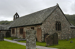
St Catherine's Church, Boot, from the southeastLocation in Cumbria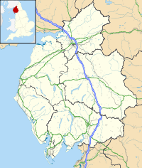
 St Catherine's Church, Boot
Coordinates: 54°23′28″N 3°16′14″W / 54.3911°N 3.2706°W OS grid reference NY 176 003 Location Boot, Cumbria Country England Denomination Anglican Website Eskdale Benefice History Dedication Saint Catherine Architecture Status Parish church Functional status Active Heritage designation Grade II Designated 8 September 1967 Architect(s) Paley and Austin (restoration) Architectural type Church Specifications Materials Stone, slate roof Administration Parish Eskdale Deanery Calder Archdeaconry West Cumberland Diocese Carlisle Province York Clergy Rector Revd. Anne Baker Assistant priest Revd Canon Jim Baker St Catherine's Church, Boot, is located in the village of Boot, Cumbria, England. It is the Anglican parish church of Eskdale in the Lake District, and is in the deanery of Calder, the archdeaconry of West Cumberland, and the diocese of Carlisle. Its benefice is united with those of Irton, St Paul, Muncaster, St Michael, and St John, Waberthwaite.[1] The church has been designated by English Heritage as a Grade II listed building.[2] It stands by the side of the River Esk.[1]
Contents
History
A church has been on the site since the 6th century.[1] The present church dates from the 14th century, with later alterations and additions.[2] It was restored in 1881 by the Lancaster architects Paley and Austin.[3]
Architecture
Exterior
St Catherine's is constructed in random rubble. It has a slate roof with a stone ridge. The church has a simple plan, consisting of a single cell in four bays, and a south porch. At the west end is a gabled double bellcote, and there is a cross on the apex of the east end. The side windows are mainly 19th-century replacements of earlier windows, and are mullioned.[2] The east window has three lights and contains Decorated-style tracery.[3]
Interior
Inside the church is an octagonal font; its bowl has low-relief carving on each face. On the south wall of the church is a benefactors' board dated 1798.[2] All the stained glass dates from between 1889 and 1896. The glass in the east and west windows is by Gibbs and Company, and that on the north and south sides is by A. Savell and Company.[3] The glass in the east window depicts Saint Catherine, the Good Shepherd, and Saint Cecilia. Windows on the south side of the church depict the Annunciation, and on the north side the Last Supper.[4] One of the bells in the bellcote was cast in 1445.[5]
See also
- List of ecclesiastical works by Paley and Austin
References
- ^ a b c St Catherine, Eskdale, Church of England, http://www.achurchnearyou.com/eskdale-st-catherine/, retrieved 13 September 2011
- ^ a b c d Church of St Catherine, Eskdale (1086695). National Heritage List for England. English Heritage. Retrieved 13 September 2011.
- ^ a b c Hyde, Matthew; Pevsner, Nikolaus (2010) [1967], Cumbria, The Buildings of England, New Haven and London: Yale University Press, p. 342, ISBN 978-0-300-12663-1
- ^ Eskdale - St Catherine's Church, Visit Cumbria, http://www.visitcumbria.com/wc/eskdale-st-catherines-church.htm, retrieved 13 September 2011
- ^ The Parish of Eskdale: Saint Catherine's Church, Churches of Eskdale, http://www.eskdale.info/eskdale-church.html, retrieved 13 September 2011
Categories:- Diocese of Carlisle
- Church of England churches in Cumbria
- Grade II listed buildings in Cumbria
- Grade II listed churches
- Paley and Austin buildings


Wikimedia Foundation. 2010.