- Lurigancho-Chosica
-
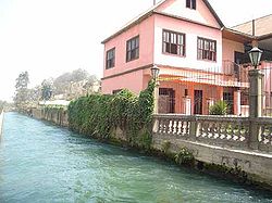
Lurigancho-Chosica — District — Una house in Chosica aside the Rímac River. 
Coat of armsLocation of Lurigancho-Chosica in the Lima provinceCoordinates: 12°02′S 77°01′W / 12.033°S 77.017°WCoordinates: 12°02′S 77°01′W / 12.033°S 77.017°W Country  Peru
PeruRegion Lima Province Lima Founded January 2, 1857 Capital Chosica Government – Mayor Luis Fernando Bueno Quino Area – Total 236.47 km2 (91.3 sq mi) Elevation 861 m (2,825 ft) Population (2005 census) – Total 125,088 – Density 529/km2 (1,370.1/sq mi) Time zone PET (UTC-5) UBIGEO 150118 Website munichosica.gob.pe Lurigancho-Chosica is a district of the Lima Province in Peru, located in the valley of the Rímac River which it shares with neighboring Chaclacayo and Ate districts. It was created on January 2, 1857.[1] Its capital is the town of Chosica. The district has a total land area of 236.47 km². Its administrative center is located 861 meters above sea level.
According to a 2002 estimate by the INEI, the district has 125,088 inhabitants and a population density of 529 persons/km². In 1999, there were 32,327 households in the district.
Its capital, Chosica, is located in the extreme east of the district, near the Huarochirí county line. Lurigancho counts on a Minor Populated Center inside the urban core of Lima, which is Santa María de Huachipa which is located in the extreme west of the district and adjacent to San Juan de Lurigancho. Other notable urban areas in this zone are Jicamarca and Cajamarquilla, where one of the principal Zinc refineries of the country is located. In the mountain zone in proximity to the refinery is located the Jicamarca Radio Observatory.
Boundaries
- North: Huarochirí Province in the Lima Region
- East: Huarochirí Province
- South: Chaclacayo and Ate
- West: San Juan de Lurigancho
References
- ^ Alberto Tauro del Pino, Enciclopedia Ilustrada del Perú, vol. X, p. 1534.
External links
- Official municipal website (www.munichosica.gob.pe)
- Chosica.com - Portal of the town of Chosica
Lima and Callao Metropolitan Area Culture · History · Landmarks · Notable people · Mayors · Other elected officials · Transportation Districts Central Lima Breña · La Victoria · Lima · Rimac South Central Lima Barranco · Jesús María · La Molina · Lince · Magdalena · Miraflores · Pueblo Libre ·San Borja · San Isidro · San Miguel · Santiago de Surco · Surquillo Cono Este Ate · Cieneguilla · Chaclacayo · El Agustino · Lurigancho (Chosica) · San Juan de Lurigancho · San Luis · Santa Anita Cono Norte Ancón · Carabayllo · Comas · Independencia · Los Olivos · Puente Piedra · San Martin de Porres · Santa Rosa Cono Sur Chorrillos · Lurín · Pachacamac · Pucusana · Punta Hermosa · Punta Negra · San Bartolo · San Juan de Miraflores · Santa María del Mar · Villa el Salvador · Villa María del Triunfo Callao Bellavista · Callao District · Carmen de la Legua Reynoso· La Perla · La Punta · Ventanilla Categories:- Districts of Lima
Wikimedia Foundation. 2010.

