- Chyornie Bratya
-
Chyornie Bratya Native name: Чёрные Братья
知理保以島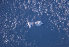
NASA picture of Chirpoy & Brat ChirpoevGeography Location Sea of Okhotsk Coordinates 45°56′N 150°02′E / 45.933°N 150.033°ECoordinates: 45°56′N 150°02′E / 45.933°N 150.033°E Archipelago Kurile Islands Area 36 km2 (13.9 sq mi) Highest elevation 691 m (2,267 ft) Country RussiaDemographics Population 0 Chyornie Bratya (Russian: Чёрные Братья;Japanese: 知理保以島) is collectively the name for a pair of uninhabited volcanic islands located between Simushir and Urup in the Kuril Islands chain in the Sea of Okhotsk in the northwest Pacific Ocean. The larger of the two is named Chirpoy, and the smaller is named Brat Chirpoev (Russian for Chirpoy's Brother). The origin of the names is uncertain: the original Ainu language name of the island was Repunmoshiri, a word meaning “place of many small birds”.
Contents
Geography
The Chirpoy islands are the remains of a partially submerged volcanic caldera which measures 8–9 km wide. The two islands are surrounded by a number of small islets and offshore rocks and together, the collective forms the Chernye Brat'ya (Russian for Black Brothers) Islands. Both islands are separated by the Snou Strait.
Chirpoy, the northernmost of the two islands, has an area of approximately 21 km², and consists of three overlapping stratovolcanoes. Vulkan Chernoga (Japanese: 大崩山), with a height of 691 metres (2,267 ft) is the tallest point on the island.
Brat Chirpoev, the southern of the two islands, has an area of approximately 16 km². However, the tallest structure out of both islands is on Brat Chirpoy where 749 metres (2,457 ft) tall Brat Chirpoev dominates the island. Brat Chirpoy is the site of the southernmost of five major Steller sea lion rookeries on the Kuril Islands.
History
Chirpoy appears on an official map showing the territories of Matsumae Domain, a feudal domain of Edo period Japan dated 1644, and these holdings were officially confirmed by the Tokugawa shogunate in 1715. Administration of the islands came under the Matsumae domain’s regional office location on Kunashir from 1756. In 1801, the Japanese government officially claimed control of the islands, incorporating them into Ezo Province (now Hokkaidō), but sovereignty passed to the Empire of Russia under the terms of the Treaty of Shimoda in 1855. Under the Treaty of Saint Petersburg (1875), sovereignty passed to the Empire of Japan along with the rest of the Kurile islands. The islands were formerly administered as part of Uruppu District of Nemuro Subprefecture of Hokkaidō.
In 1952, upon signing the Treaty of San Francisco, Japan renounced its claim to the islands.[1]. The islands are uninhabited and are administered as part of the Sakhalin Oblast of the Russian Federation.
References
External links

 Islands of the Sea of OkhotskAntsiferov · Arka · Atlasov · Banka Zotova · Baydukov Island · Belyakov Island · Bolshoy Chome · Bolshoy Shantar · Brat Chirpoyev · Broutona · Chastye Islands · Chetyre Paltsa · Chirinkotan · Chirpoy · Chkalov Island · Dobrzhansky Island · Ekarma · Feklistova · Hokkaidō · Iony Island · Iturup · Kamen-Mukdykyn · Kamen Opasnosti · Kekurniy Island · Ketoy · Khalpili Islands · Kharimkotan · Konus · Krayniy Island · Kunashir · Kuril Islands · Makanrushi · Matua · Menshikov Island · Morskaya Matuga · Nansikan Island · Nedorazumeniya · Onekotan · Oremif · Paramushir · Pilamif · Raikoke · Rasshua · Rechnaya Matuga · Reyneke Island · Rovnyy · Sakhalin · Shantar Islands · Shelikan · Shiashkotan · Shumshu · Simushir · Spafaryev Islands · Talan Island · Telan Island · Tretiy Island · Tyuleniy Island · Umara · Urup · Ush · Ushishir · Vtoroy · Yam Islands · Yengalychev Island · Zavyalov · ZubchatyCategories:
- Chyornie Bratya
- Active volcanoes

Wikimedia Foundation. 2010.