- Chirinkotan
-
Chirinkotan Native name: Чиринкотан
知林古丹島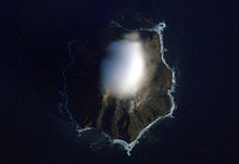
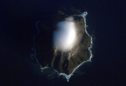
NASA picture of Chirinkotan Island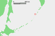
Geography Location Sea of Okhotsk Coordinates 48°59′N 153°29′E / 48.98°N 153.48°E Archipelago Kurile Islands Area 6 km2 (2.3 sq mi) Highest elevation 742 m (2,434 ft) Highest point Masaochi Country RussiaDemographics Population 0 Chirinkotan (Russian: Чиринкотан; Japanese 知林古丹島; Chirinkotan-tō) is an uninhabited volcanic island located in the centre of the Kuril Islands chain in the Sea of Okhotsk in the northwest Pacific Ocean. Its name is derived from the Ainu language for "mudslide". It is located 30 kilometers west of Ekarma, its nearest neighbor.
Contents
Geology
Chirinkotan is at the far end of a volcanic chain extending nearly 50 km west of the central part of the main Kuril Islands arc. The island is the top of a partially submerged stratovolcano rising approximately 3000 meters from the floor of the Sea of Okhotsk, and is roughly circular with an area of 6 km² [1] The island’s highest point (“Masaochi” in Ainu) is 742 meters high, is still active volcano with major eruptions recorded in 1760, 1884, 1900, 1979, 1986 and 2004. Reports of a 1955 eruption are unconfirmed. The caldera is approximately one kilometer wide, with a depth of 300 to 400 meters, and is breached on its south-east side. The shores of the island are steep cliffs, making landing by small boat impossible.
History
Chirinkotan has had no permanent habitation. Claimed by the Empire of Russia, sovereignty was passed to the Empire of Japan per the Treaty of Saint Petersburg (1875) along with the rest of the Kurile Islands. The island was formerly administered as part of Shumushu District of Nemuro Subprefecture of Hokkaidō. After World War II, the island came under the control of the Soviet Union, and is now administered as part of the Sakhalin Oblast of the Russian Federation.
See also
References
- "Chirinkotan". Global Volcanism Program, Smithsonian Institution. http://www.volcano.si.edu/world/volcano.cfm?vnum=0900-21=.
- Oceandots entry
External links
Further reading
- Gorshkov, G. S. Volcanism and the Upper Mantle Investigations in the Kurile Island Arc. Monographs in geoscience. New York: Plenum Press, 1970. ISBN 0-306-30407-4
- Krasheninnikov, Stepan Petrovich, and James Greive. The History of Kamtschatka and the Kurilski Islands, with the Countries Adjacent. Chicago: Quadrangle Books, 1963.
- Rees, David. The Soviet Seizure of the Kuriles. New York: Praeger, 1985. ISBN 0-03-002552-4
- Takahashi, Hideki, and Masahiro Ōhara. Biodiversity and Biogeography of the Kuril Islands and Sakhalin. Bulletin of the Hokkaido University Museum, no. 2-. Sapporo, Japan: Hokkaido University Museum, 2004.
Notes
- ^ "International Kuril Island Project(IKIP)". University of Washington Fish Collection or the respective authors. http://www.washington.edu/burkemuseum/collections/ichthyology/okhotskia/ikip/Info/physical.html.

 Islands of the Sea of OkhotskAntsiferov · Arka · Atlasov · Banka Zotova · Baydukov Island · Belyakov Island · Bolshoy Chome · Bolshoy Shantar · Brat Chirpoyev · Broutona · Chastye Islands · Chetyre Paltsa · Chirinkotan · Chirpoy · Chkalov Island · Dobrzhansky Island · Ekarma · Feklistova · Hokkaidō · Iony Island · Iturup · Kamen-Mukdykyn · Kamen Opasnosti · Kekurniy Island · Ketoy · Khalpili Islands · Kharimkotan · Konus · Krayniy Island · Kunashir · Kuril Islands · Makanrushi · Matua · Menshikov Island · Morskaya Matuga · Nansikan Island · Nedorazumeniya · Onekotan · Oremif · Paramushir · Pilamif · Raikoke · Rasshua · Rechnaya Matuga · Reyneke Island · Rovnyy · Sakhalin · Shantar Islands · Shelikan · Shiashkotan · Shumshu · Simushir · Spafaryev Islands · Talan Island · Telan Island · Tretiy Island · Tyuleniy Island · Umara · Urup · Ush · Ushishir · Vtoroy · Yam Islands · Yengalychev Island · Zavyalov · Zubchaty
This Sakhalin Oblast location article is a stub. You can help Wikipedia by expanding it.