- 2011 Puyehue-Cordón Caulle eruption
-
Coordinates: 40°35′25″S 72°07′02″W / 40.59028°S 72.11722°W The 2011 Puyehue-Cordón Caulle eruption ([puˈʝewe]) is a volcanic eruption that began in the Puyehue-Cordón Caulle volcanic complex in Chile on June 4, 2011. Misleadingly called by media the Puyehue eruption - the eruption is actually from the Cordon Caulle fissure.[1] At least 3,500 people were evacuated from nearby areas,[2] while the ash cloud was blown across cities all around the Southern hemisphere, including Bariloche, Buenos Aires, Montevideo, Stanley, Porto Alegre, Cape Town, Hobart, Perth, Adelaide, Sydney, Melbourne, Wellington and Auckland, forcing airlines to cancel hundreds of international and domestic flights and causing travel chaos.
By 18 June the ash cloud had completed its first circle of the globe. The Chilean civil aviation authority said that "the tip of the cloud that has travelled around the world has more or less reached the town of Coyhaique", about 600 kilometres south of the Puyehue-Cordón Caulle.[3] An estimated one hundred million tons of ash, sand and pumice were ejected - requiring power equivalent to 70 atomic bombs.[4]
 Topography of the region. The Puyehue-Cordón Caulle massif is located between Ranco and Puyehue Lake
Cordón Caulle is a volcanic fissure and has erupted many times in recorded history, most recently in 1960, following the 1960 Valdivia earthquake days earlier, [5] whereas the Puyehue stratocone has remained dormant.
Contents
Eruption
The Southern Andean Volcano Observatory (OVDAS) of Servicio Nacional de Geología y Minería de Chile (SERNAGEOMIN) reported on April 27, 2011, 15:30 local time, an increased seismicity at the Puyehue-Cordón Caulle and set the alert Level to 3, Yellow.[6]
Between 20:00 on June 2 and 19:59 on June 3, OVDAS reported[7] that about 1,450 earthquakes at Puyehue-Cordón Caulle were detected, or an average of about 60 earthquakes per hour. Scientists and regional authorities flew over the volcano, noting no significant changes. The alert level remained at 3, yellow. Area residents reported feeling earthquakes during the evening of June 3 through the morning of June 4.
On June 4, 11:30 local time, a new round of eruption in the Puyehue volcano began. For a six-hour period on 4 June seismic activity increased to an average of 230 earthquakes per hour, at depths of 1–4 km. About 12 events were magnitudes greater than 4 of Richter magnitude, and 50 events were magnitudes greater than 3. The alert level was raised to 5, red.[8][9]
At 15:15 local time OVDAS reported an explosion and a 5 kilometres (3.1 mi)-wide ash-and-gas plume that rose to an altitude of 10 kilometres (33,000 ft) above sea level. The plume drifted south at 5 kilometres (16,000 ft) altitude, and southeast and east at 10 kilometres (33,000 ft) altitude. The alert level was raised to 6, red.[10]
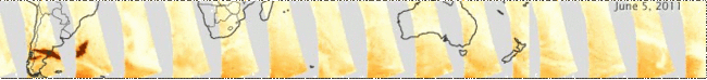 The images show the density of particles in the atmosphere (aerosols) as measured by the Ozone Monitoring Instrument on the Aura satellite. The series starts on June 5, 2011, the day after the eruption began, and continues through June 13.
After 18 days it first erupted, Lava begun spilling from volcano, heading west and flowing "slowly by a channel about 50 meters wide and 100 feet long."[11][12]
According to Argentine physicists, the eruption sent one hundred million tons of ash, sand and pumice stone, equivalent to the load of 24 million trucks of sand and released power equivalent to 70 atomic bombs.[4]
Evacuation
A "red alert" was declared pre-emptively by the National Emergencies' Office (ONEMI) for regions near the volcano: Puyehue, Río Bueno, Futrono, and Lago Ranco; initially 600 persons were evacuated. The "red alert" was later extended for the Los Ríos Region area: the areas of Pocura, Pichico, Los Venados, Contrafuerte, El Zapallo, Futangue, Pitreño, Trahuico, Riñinahue Alto, Ranquil, Chanco, Epulafquén, Las Quemas, Licán, Boqueal, Rucatayo, and Mantilhue were evacuated; and areas in the Los Lagos Region such as El Retiro, Anticura, El Caulle, Forestal Comaco, and Anticura Pajaritos were also evacuated, increasing the number to at least 3,000 total evacuated people.[13] It was reported that, at first, large land- and farm-owners in Chilean rural areas near the volcano did not allow workers to be evacuated.[14] According to Chilean authorities, the evacuated persons "would be relocated in temporary shelters in safe areas." There are no reports of deaths or injuries.
The families who refused to be evacuated from the riverbed of Rio Nilahue were removed by force by the Carabineros de Chile after a resolution of the Appeal Court of Valdivia. It took the police more than 8 hours to evacuate 40 people. People resisted mainly because they had to leave their livestock behind.[15] Small livestock farmers were permitted to check and care for their livestock once a day.[16]
On June 17, 2011 OVDAS reported that the ash-and-gas plume reached 3 kilometres (1.9 mi) above sea level, and the frequency of earthquakes had dropped to 5 per hour. They reduced the alert level from 6 (moderate eruption) to 5 (imminent eruption), and at least 100 evacuated persons were allowed to return home.[17][18] People from the Northeast side of the Cordón (Nilahue and Gol Gol Valley) will stay in the shelters.
On June 19 the ONEMI decided that all 4,200 evacuees could return home, as the scale of the eruption continued to decrease.[19]
Ash cloud over Argentina and Uruguay
The ash cloud crossed Chile's borders and precipitated over the Argentine cities of Villa la Angostura, Bariloche and the northern part of Chubut[20] province.[21][22] The eruption was reported to have produced lightning and strong thunderstorms.[23][24] Argentine Minister of Defense Arturo Puricelli ordered that "the Argentine Army personnel, means of transport, water treatment plants, and other equipment of VI Mountain Brigade in the province of Neuquén" be moved to the affected areas on the Argentine border with Chile.[25]
In Argentina's affected cities, people have been recommended to stay indoors.[26]
On June 5 the ash rain in Bariloche ceased. There were reports that the ash had caused power outages[27] and prompted the local airport to be closed. The Bariloche Atomic Centre reported that the ashes contain no crystal phases of quartz or cristobalite.[28]
On June 9 ash clouds from Puyehue reached Uruguay, forcing most flights to be cancelled.[29] On June 11 the ash clouds reached the southern tip of New Zealand, with unusual sunsets reported in Invercargill.
Further disruption was caused by ash in October 2011, with airports at Mendoza, Bariloche and Buenos Aires closed and flights to Buenos Aires and Montevideo cancelled.[30] This was ash from the earlier eruption which had been deposited across Patagonia and stirred up by high winds.[31] Some areas of Argentina close to the Chilean border still had ash falling almost daily four months after the June eruption.[32]
-
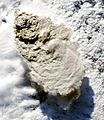
Image from NASA's Aqua satellite showing the heavy ash cloud on June 4, 2011.
-

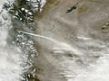
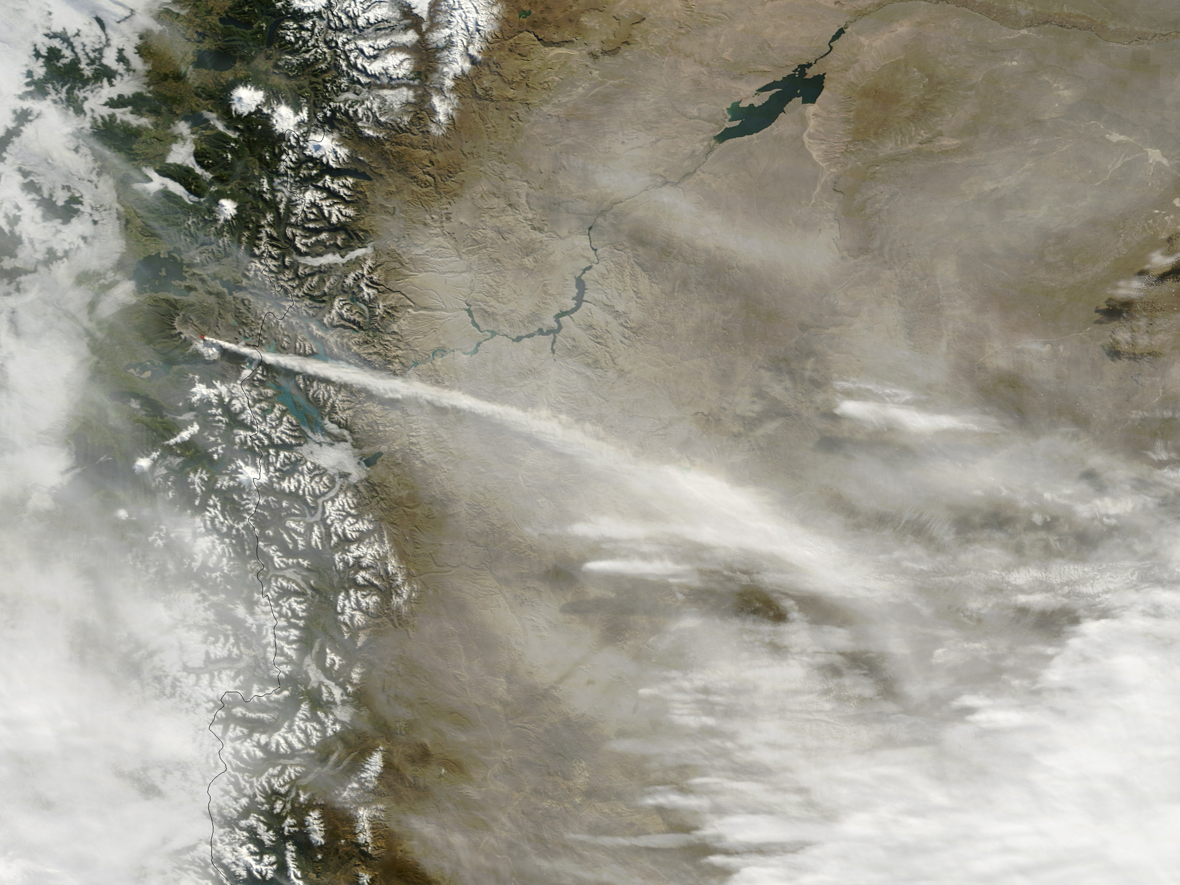
Image showing a large plume of volcanic ash blowing about 800 kilometers east and then northeast over Argentina.
-
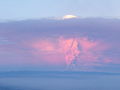
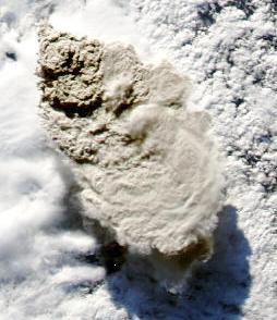
Airborne image of ash cloud on June 5, 2011
-
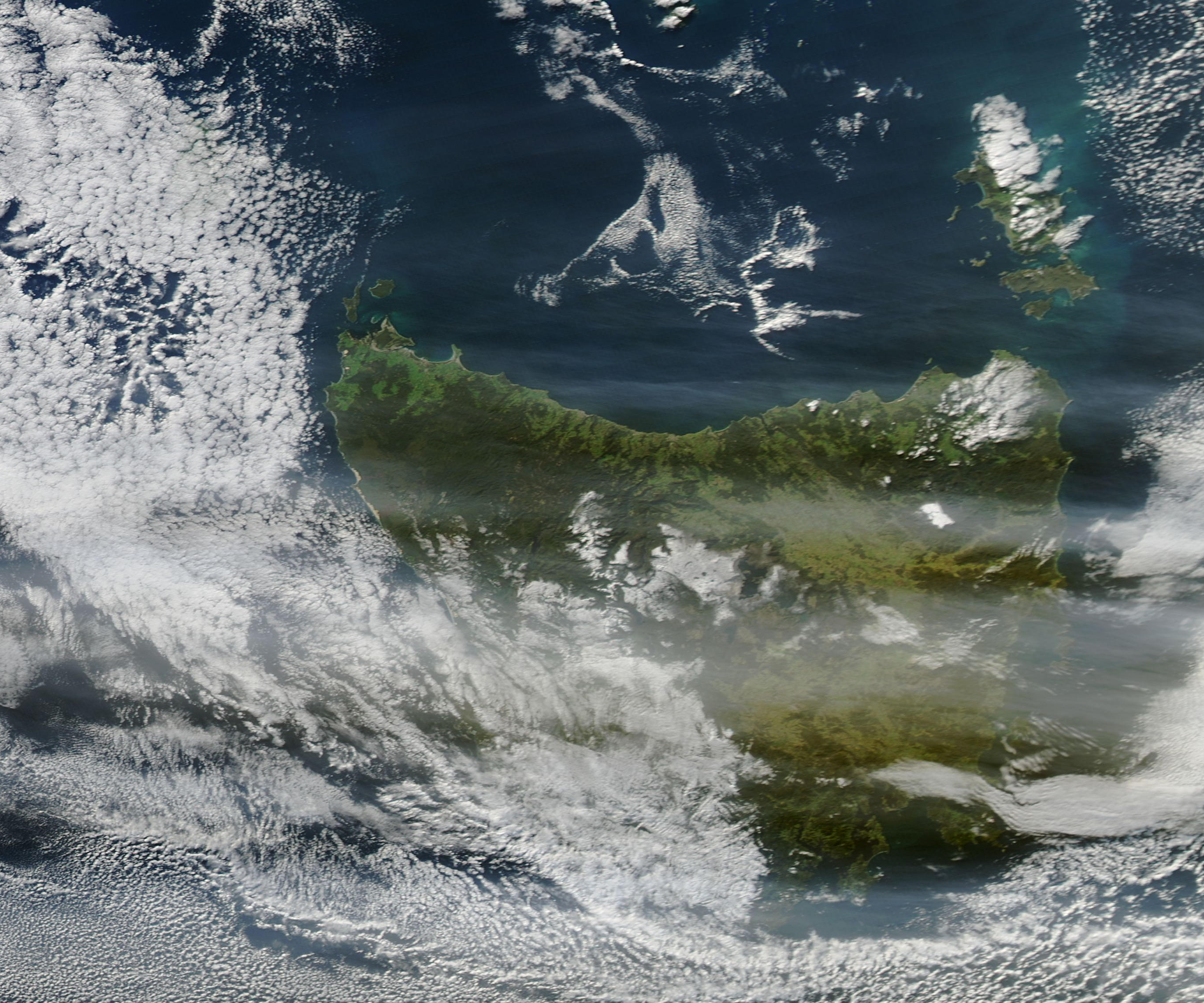
The plume blowing toward the east-south-east on July 08, 2011.
River temperature and contamination
The eruption of the Chilean volcano Puyehue significantly affected the surrounding environment. The temperature of the Nilahue River rose to 45 °C (113 °F) and killed an estimated 4.5 million fish with an economic impact on fish farming in the area. The cattle economy was also damaged.[33][34]
Scientists from the Southern University of Chile analyzed waters from the Nilahue and Golgol rivers, the two principal collectors of waters from Cordón Caulle. Scientists found that if solid particles were removed the water was safe to drink.[35]
Livestock
The ash cloud led Argentina to declare a state of emergency for farmers as the prolonged eruption's continued effect on the 2 million head of sheep that graze in southern Argentina. Chubut and Río Negro Provinces had suffered five years of drought, and the ash destroyed the little pastureland still serviceable. 750.000 sheep suffered the consequences, and Rio Negro officials said 60,000 head of cattle also were "at risk." [36]
Transport disruption
Ash poses a significant threat to aircraft because once sucked into engines, it can be transformed into molten glass by the high temperatures and potentially cause an engine to fail.
On the ground lava, but also ash and volcanic stone can impede the vehicle movement.
Chile
Initially, because of the wind direction (to east), the flights within Chile were not interrupted and only the highway Route 215-CH and the "Cardenal Samore Pass" was reported to be covered by 10 to 15 cm of "volcanic stone" by Chilean authorities.[37] and closed down on June 4.[38]
The Chilean government increased the frequency of barges on the Pirihueico Lake in Huahum Pass to transport passengers traveling between Chile and Argentina. Huahum Pass is approximately 100 km north of the closed "Cardenal Samore Pass".
On June 22, as the ash cloud rounded the world und "returned" to Chile, the Chilean airline LAN cancelled flights to Temuco and Valdivia in the south of the country.[39]
Argentina, Uruguay and Brazil
On June 4 at approximately 4:30 pm local time, Neuquén Airport was closed due to the ash cloud. [40] Ash fell across a wide swathe of South America, forcing cancellation of most flights across the southern half of the continent. A planned meeting between the presidents of Argentina and Uruguay was cancelled because José Mujica was unable to fly to Buenos Aires.[41]
South Brazil suffered a lot with flights between Buenos Aires, Montevideo, Santiago, Curitiba, Florianopolis and Porto Alegre cancelled.
Falkland Islands
Three Falkland Islands air links with the United Kingdom were merged onto one aircraft. Allocation operated according to a priority system, with passengers ranked in importance. The three highest categories were 1. Travel for medical reasons (as designated by the Director of Health and Education); 2. Students returning to study (as designated by the Director of Health and Education); 3. Business passengers at risk of a serious and unavoidable impact on their business. Passengers were strongly recommended to travel LAN Airlines as the ash cloud did not cover the route over Punta Arenas.[42]
South Africa
On June 14 the South African Civil Aviation Authority released a statement saying that the ash cloud was being monitored and that there was no operational impact to the airlines[43], however, two local airlines, South African Airways and Kulula.com, cancelled some flights to and from Cape Town International Airport and East London Airport on June 18; operations later returned to normal[44],[45]
Australia and New Zealand
At its greatest extent, strong winds had carried the ash cloud from Puyehue a great distance at high altitude, and the ash remained present for several days at distinct altitude bands between 20,000–35,000 feet over New Zealand and southern Australia, disrupting flights between Adelaide, Melbourne, Perth, and all of Tasmania and New Zealand.[46][47][48][49][50] Initially Air New Zealand managed to avoid cancellations by flying their aircraft at lower altitudes (20,000 feet) in order to avoid ash, requiring 10% more fuel. Cancellations started by June 15.[51] [52] Subsequently Rob Fyfe of Air New Zealand hit back at malicious rumours from Australian airlines that continuing to fly was unsafe. [53]
Virgin Australia resumed flights to southern Australia by June 13, but Qantas and its subsidiary Jetstar did not resume flights until June 14 and 15 because the Volcanic Ash Advisory Centre in Australia did not have the technology to determine the thickness of the plume.[54] [55][56] Losses for the airlines are expected to be in the millions.[57]
Flights to and from Perth were disrupted by the approaching plume of ash, extending from 15,000 to 35,000 feet.[58]
On June 20 flights were once again cancelled at Adelaide and Mildura airports.[59] On June 21 and 22 flights to Sydney, Canberra, Melbourne, Newcastle, Wagga Wagga and Albury airports were cancelled due to the ash cloud.[60] As of 22 June 2011[update] the ash cloud was expected to move from Australia to New Zealand.[61]
Economic and financial impact
Macquarie Equities placed the cost of disruptions to airlines at A$21 million for Qantas and $11 million for Virgin Australia.[61] The tourism industry was also impacted, costing A$15 million during the two-week period,[62] with CEO John Lee of lobbying group Tourism & Transport Forum stating a daily cost of at least A$10 million as a result of complete closure of Sydney and Melbourne's main airports.[63]
The government of Neuquen province, Argentina, declared an economic emergency as the ash cloud was harming tourism and threatening livestock.[64] The decree by provincial governor Jorge Sapag allowed those affected to claim for tax and other benefits.[64] In Argentina ashes from Puyehue were advertised for sale and some were also used for making handicrafts.[65] The intendant of Villa La Angostura asured that there were plenty of ideas of what to do with the ashes, among them bricks.[65] In addition ashes were used to improve gravel roads around San Carlos de Bariloche.[65]
The Argentine president announced on national television plans to supply $2.41 billion dollars to 1,400 farmers and businesses in the area affected by the ash cloud. They also plan to spend $7 million on the cleanup operation, and double social benefits, and defer tax payments for the hardest hit regions.[66]
See also
- List of volcanoes in Chile
- Volcanism of Chile
References
- ^ Erupción del Cordón Caulle es similar a la de mayo de 1960
- ^ Volcán Puyehue: Gobierno evacua a 3.500 personas La Nación, June 4, 2011 (Spanish)
- ^ "Chilean ash makes its way home". The Sydney Morning Herald. June 18, 2011. http://www.smh.com.au/world/chilean-ash-makes-its-way-home-20110618-1g8mp.html. Retrieved June 21, 2011.
- ^ a b Article Chile´s Puyehue Volcano eruption equals 70 atomic bombs? in Buenos Aires Herald on July 14, 2011, retrieved on July 14, 2011
- ^ "Chile: Puyehue volcano chain erupts, forcing evacuation". BBC Online. June 5, 2011. http://www.bbc.co.uk/news/world-latin-america-13657187. Retrieved June 5, 2011.
- ^ Reporte Especial No 13 de Actividad Volcánica (Spanish)
- ^ Reporte Especial de Actividad Volcánica No 26 (Spanish)
- ^ Reporte Especial de Actividad Volcánica No 27 (Spanish)
- ^ Guzmán, Gerson (June 4, 2011). "Comienza proceso eruptivo en el volcán Puyehue" (in Spanish). Radio Bío-Bío. http://www.biobiochile.cl/2011/06/04/comienza-proceso-eruptivo-del-complejo-volcanico-cordon-caulle.shtml. Retrieved June 4, 2011.
- ^ Reporte Especial de Actividad Volcánica No 28 (Spanish)
- ^ Puyehue volcano began to fire lava on 23. June 2011
- ^ Reporte Especial de Actividad Volcánica No 48
- ^ Complejo Puyehue – Cordón Caulle entró en fase eruptiva, ONEMI, June 4, 2011. La responsabilidad de la conducción nacional de la Protección Civil en Chile corresponde al Ministerio del Interior, la que ejerce mediante su servicio especializado: ONEMI, Access date: June 4, 2011
- ^ "Dueños de fundos prohibieron a sus trabajadores evacuar tras erupción volcánica" (in Spanish). June 4, 2011: Radio Bío Bío. http://www.biobiochile.cl/2011/06/04/duenos-de-fundos-prohibieron-a-sus-trabajadores-evacuar-tras-erupcion-volcanica.shtml. Retrieved June 5, 2011.
- ^ Tele 13 on 10 June 2011
- ^ Life in the shelter: evacuees from Volcán Puyehue try to regain normality
- ^ Article Sernageomin baja nivel de alerta volcánica y al menos 100 evacuados pueden retornar in newspaper "La Tercera" on June 17, 2011, retrieved on June 18, 2011 (Spanish)
- ^ Article Volcán Puyehue: Algunos evacuados regresarán a sus casas (Spanish)
- ^ Article 4,200 evacuated people may return home in earthquake-report.com on June 19, 2011 retrieved on June 19, 2011
- ^ "Las cenizas del Puyehue invaden Chubut" (in Spanish). El Diario 24 Tucumán. http://www.eldiario24.com/nota.php?id=223444. Retrieved 5 June 2011.
- ^ Evacúan a 3.500 personas por la erupción del volcán Puyehue en Chile, [Infobae.com],04-06-11, access date:June 4, 2011.
- ^ Aumentan a 3500 los evacuados por actividad volcánica en Puyehue-Cordón Caulle
- ^ La columna de humo del volcán Puyehue alcanza los 10 kilómetros de alto
- ^ [1]
- ^ "Movilizan al Ejército por la erupción del volcán Puyehue" (in Spanish). Reporte Platense. http://reporteplatense.com.ar/index.php?option=com_content&view=article&id=2822:movilizan-al-ejercito-por-la-erupcion-del-volcan-puyehue&catid=16:sociedad&Itemid=68. Retrieved 5 June 2011.
- ^ "No hubo en Bariloche nueva lluvia de cenizas pero se mantiene el alerta – Agencia de Noticias lisher=6 June 2011". http://www.anbariloche.com.ar/noticia.php?nota=21719. Retrieved 6 June 2011.
- ^ "La CEB informa sobre cortes de luz causados por la lluvia de cenizas" (in spanish). 5 June 2011. http://www.ddbariloche.com.ar/nota_LA-CEB-INFORMA-SOBRE-CORTES-DE-LUZ-CAUSADOS-POR-LA-LLUVIA-DE-CENIZAS.html. Retrieved 5 June 2011.
- ^ "Cesó la caída de cenizas en Bariloche, pero se mantiene la emergencia - lanacion.com". La Nación (5 June 2011). http://www.lanacion.com.ar/1379096-tras-la-erupcion-de-un-volcan-chileno-bariloche-quedo-cubierta-por-cenizas. Retrieved 5 June 2011.
- ^ "Nube de cenizas del cordón Caulle alcanza Uruguay y obliga a cancelar vuelos". http://www.emol.com/noticias/internacional/detalle/detallenoticias.asp?idnoticia=486350.
- ^ "Argentina ash cloud: Flights grounded in Argentina and Uruguay". dailymail.co.uk. 17 October 2011. http://www.dailymail.co.uk/travel/article-2050072/Argentina-ash-cloud-Flights-grounded-Argentina-Uruguay.html. Retrieved 23 October 2011.
- ^ "Argentina, Uruguay flights resume after volcanic ash delays". seattletimes.nwsource.com. 17 October 2011. http://seattletimes.nwsource.com/html/nationworld/2016528120_apltchileanvolcanoflights.html. Retrieved 23 October 2011.
- ^ Hernandez, Vladimir (4 October 2011). "Puyehue volcano ash still clouds life in Argentina". bbc.co.uk. http://www.bbc.co.uk/news/world-latin-america-15148876. Retrieved 23 October 2011.
- ^ "El Caulle: erupción sube a 45°C temperatura del río Nilahue y autoridad monitorea riesgos" (in Spanish). La Tercera (Chile). 9 June 2011. http://diario.latercera.com/2011/06/09/01/contenido/pais/31-72057-9-el-caulle-erupcion-sube-a-45-c-temperatura-del-rio-nilahue-y-autoridad-monitorea.shtml.
- ^ Article Puyehue disrupts air traffic on 10 June 2011, retrieved on 10 June 2011
- ^ Estudio sostiene que ríos del Cordón Caulle no están contaminados y son potables, La Tercera.
- ^ Agriculture emergency is Argentine Patagonia because of the volcanic ash
- ^ Erupción de Cordón Caulle: Aún no hay fecha fija para el regreso de los evacuados, Emol
- ^ [2]
- ^ Puyehue Volcano Expels Lava
- ^ "Volcanic Ash from Puyehue Halts Argentina’s Air Traffic Again Today". International Business Times. http://www.ibtimes.com/articles/160305/20110609/chile-volcano-puyehue-volcanic-ash-cloud-argentina-argentina-flights-lan-volcanologist-aerolineas-ar.htm. Retrieved June 9, 2011.
- ^ Google news from Associated Press Volcanic ash dusts Argentine capital, cuts flights
- ^ Article Falklands rations seats on the UK airbridge forced by the volcanic ash in Mercopress on June 10, 2011 retrieved on June 15, 2011
- ^ SACAA. "SACAA and ATNS monitors volcanic ash situation". http://www.caa.co.za/press_files/2011/Volcanic_Ash_Situation.pdf. Retrieved June 19, 2011.
- ^ SouthAfrica.to. "SAA volcanic ash flight cancellations". http://www.southafrica.to/transport/Airlines/SAA-flights/2011/SAA-Volcanic-Ash-cancellations.php. Retrieved June 19, 2011.
- ^ "SA flights delayed by Chile volcanic ash cloud". Mail & Guardian Online. SAPA. June 19, 2011. http://mg.co.za/article/2011-06-19-sa-flights-delayed-by-chile-volcanic-ash-cloud. Retrieved June 19, 2011.
- ^ Cox, Nicole (June 11, 2011). "Volcanic ash won't affect flights". Perth Now. http://www.perthnow.com.au/news/western-australia/volcanic-ash-wont-affect-flights-qantas/story-e6frg13u-1226073445654. Retrieved June 17, 2011.
- ^ "Ash cloud forces flight cancellations". Sky News. June 11, 2011. http://www.skynews.com.au/topstories/article.aspx?id=624339&vId=2477065. Retrieved June 17, 2011.
- ^ Critchlow, Andrew; Craymer, Lucy (June 11, 2011). "Ash Disrupts Flights in Australia, New Zealand". The Wall Street Journal. http://online.wsj.com/article/SB10001424052702303714704576380882531141952.html?mod=googlenews_wsj. Retrieved June 12, 2011.
- ^ "More flights cancelled in 'exceptional' ash event". ABC News (Australian Broadcasting Corporation). June 12, 2011. http://www.abc.net.au/news/stories/2011/06/12/3241974.htm. Retrieved June 12, 2011.
- ^ Staff (June 13, 2011). "Qantas, Jetstar, Tiger and Virgin ground flights at Melbourne Airport". Australian Associated Press. http://www.heraldsun.com.au/news/volcanic-ash-triggers-aussie-air-travel-chaos-as-fog-delays-melbourne-flights/story-e6frf7jo-1226073975658. Retrieved June 13, 2011.
- ^ "Volcanic ash halts New Zealand flights". BBC News. June 12, 2011. http://www.bbc.co.uk/news/world-asia-pacific-13743107. Retrieved June 13, 2011.
- ^ "Chile volcanic ash cloud moves higher". Stuff. June 13, 2011. http://www.stuff.co.nz/travel/5134457/Chile-volcano-ash-cloud-moves-higher. Retrieved September 1, 2011.
- ^ "Air New Zealand hits back at 'malicious rumours". Stuff. June 22, 2011. http://www.stuff.co.nz/business/industries/5178854/Air-New-Zealand-hits-back-at-malicious-rumours. Retrieved September 1, 2011.
- ^ "Travel misery as ash grounds Australia, NZ flights". The West Australian. Agence France-Presse. June 13, 2011. http://au.news.yahoo.com/thewest/a/-/world/9625850/travel-misery-as-ash-grounds-australia-nz-flights/. Retrieved August 7, 2011.
- ^ Calligeros, Marissa (June 13, 2011). "Ash cloud airline cancellations 'ultra conservative'". Brisbane Times. http://www.brisbanetimes.com.au/travel/travel-news/ash-cloud-airline-cancellations-ultra-conservative-20110613-1fznb.html?from=brisbanetimes_sb. Retrieved June 13, 2011.
- ^ "Virgin flies but Qantas waits amid ash chaos". 774 ABC Melbourne (Australian Broadcasting Corporation). June 13, 2011. http://www.abc.net.au/news/stories/2011/06/12/3241974.htm?site=melbourne. Retrieved June, 15 2011.
- ^ Williams, Felicity (June 14, 2011). "Ash impact likely to cost millions". Perth Now. http://www.perthnow.com.au/business/business-old/too-early-to-predict-ash-impact/story-e6frg2qu-1226074997727. Retrieved June 14, 2011.
- ^ "Ash plume stops Perth flights". The Sydney Morning Herald. Australian Associated Press. June 15, 2011. http://news.smh.com.au/breaking-news-national/ash-plume-stops-perth-flights-20110615-1g2wq.html. Retrieved June 17, 2011.
- ^ Heasley, Andrew (June 20, 2011). "Ash cloud returns: Virgin, Tiger suspend flights". WAToday. http://www.watoday.com.au/travel/travel-news/ash-cloud-returns-virgin-tiger-suspend-flights-20110620-1gb9f.html. Retrieved June 20, 2011.
- ^ Haynes, Rhys (June 21, 2011). "Volcanic ash cloud forces Qantas to cancel Wednesday flights, international flights delayed". The Daily Telegraph. http://www.dailytelegraph.com.au/news/second-volcanic-ash-cloud-coming/story-e6freuy9-1226079369713. Retrieved June 21, 2011.
- ^ a b "Australian flights resume as Chile volcano ash clears". BBC News. 22 June 2011. http://www.bbc.co.uk/news/world-asia-pacific-13869876. Retrieved 22 June 2011.
- ^ Taylor, Rob; Perry, Michael (22 June 2011). "Ash cloud clears, Australia flights resume". Reuters (Canberra). http://www.reuters.com/article/2011/06/22/us-qantas-ash-idUSTRE75L08K20110622. Retrieved 23 June 2011.
- ^ Daley, Gemma (22 June 2011). "Australia ash clears after flight halt prompts A$2,100 cab ride". Bloomberg. http://www.bloomberg.com/news/2011-06-21/australians-take-a-2-100-car-rides-as-ash-grounds-qantas-planes.html. Retrieved 24 Jun 2011.
- ^ a b "Chilean Volcano's Cloud of Ash Circles the Globe and Comes Home Again". Fox News Latino. 18 June 2011. http://latino.foxnews.com/latino/news/2011/06/18/chilean-volcanos-cloud-ash-circles-globe-and-comes-home-again. Retrieved 23 June 2011.
- ^ a b c Las ingeniosas soluciones para deshacerse de las cenizas del cordón Caulle
- ^ "Argentina unveils plan to mitigate cost of volcano". 5 July 2011. http://www.google.com/hostednews/afp/article/ALeqM5hw0GDOYkZ8mbOKPtNUFzk5tRa4Bw?docId=CNG.89e7aaafd19ebbe231f710f5d5b53c29.111.
External links
- OVDAS reports
- Chile's Volcano Erupts: Crazy Skies — slideshow by Life magazine
- Volcanic Ash and Pumice From Puyehue, slideshow from The Atlantic, Jun 17, 2011
Categories:- 2011 in Chile
- 2011 in Argentina
- 2011 natural disasters
- Volcanism of Chile
- Natural disasters in Chile
- Natural disasters in Argentina
- 21st-century volcanic events
- Los Ríos Region
-


Wikimedia Foundation. 2010.