- List of villages in Gower
-
Gower Peninsula Country Wales Sovereign state United Kingdom Dialling code 01792 Police Fire Ambulance Welsh EU Parliament Wales List of places: UK • Wales • The Gower Peninsula (Welsh: Gŵyr) in the City and County of Swansea in south Wales in Britain is an Area of Outstanding Natural Beauty. It contains over twenty villages and communities.
Contents
Villages
Bishopston
Main article: Bishopston, SwanseaBishopston - or Llandeilo Ferwallt - is an inland village, 6 miles (9.5 km) west-southwest of Swansea and near the beaches of Caswell Bay, Brandy Cove and Pwll Du. One of the larger villages in Gower, it has its own rugby club, South Gower Rugby Football Club, and its own primary and comprehensive schools. (Bishopston is part of Swansea's Bishopston ward.)
Bishopston church, at the head of Bishopston Valley, is dedicated to Saint Teilo, who gives the village its Welsh name. The church contains a plain, massive font of Romanesque type, and its tower holds two 18th-century bells. In the churchyard are the remains of an old stone cross.
Cheriton
Cheriton, near the north coast, is popular with summer tourists as a place to stay whilst exploring the beaches in the local area.[1] The 13th-century church of saint Catwg (or Cadoc) is one of the most beautiful in Gower, and is Grade 1 listed. The psychoanalyst Ernest Jones is buried in its churchyard.
Footpaths lead south-east to Stembridge and south-west to Llangenydd.[2]51°36′54″N 4°14′25″W / 51.61506°N 4.24035°W
Crofty
Crofty, on the north coast, is a small cockling village, situated between Penclawdd and Llanmorlais. 51°38′18.00″N 4°07′33.00″W / 51.63833°N 4.12583°W
Gowerton
Main article: GowertonThe inland village of Gowerton (Welsh, Tregwyr), about 4 miles north west of Swansea city centre, is a gateway to Gower. Its original name was Ffosfelin; it has also been known as Gwter Felen. (The village falls within the Gowerton electoral ward of Swansea.)
In 1980, the Welsh National Eisteddfod was hosted on the 'Elba' area of the village. The Eisteddfod stone (Gorsedd stones) is located on the round-about opposite the garage on the road to Penclawdd.[3]
Ilston
Ilston is an inland village. It has its own community council. The population of the community in the United Kingdom Census 2001 was 538. The name of the village (Welsh, Llan Illtyd) is thought to have originated from Saint Illtud. The village is home to a brook, a 13th-century parish church (which has a 15th-century bell inscribed with a prayer to St Thomas) and a National Trust limestone quarry.[4] The community is surrounded by common land used as grazing land, woodlands and fields. Coordinates: 51°35′38″N 4°04′49″W / 51.59399°N 4.08026°W
See also Ilston Book
Llangennith
Main article: LlangennithLlangennith, in north-west Gower, has a scattering of houses and one pub - the Kings Head. It sits at a crossroads: Moor Lane leads west to a caravan park near Rhossili Bay; and Burrows Lane leads north to a caravan park overlooking Broughton Bay.
The 12th-century village church, St. Cenydd's Church, is the largest in Gower, and was founded by St. Cenydd, who in the 6th century made a hermitage here, which was destroyed by Vikings in 986.
A painting of Worm's Head from Llangennydd was made by Cedric Morris.
Llanmadoc
Llanmadoc is in the north west of Gower. The village is named after the churchyard of St Madoc, who founded his hermitage or monastery here in the 6th century. The 13th century building was restored in 1865, but retains a Romanesque font and a Romano-British tombstone. [5] Llanmadoc Hill, formed of Old Red Sandstone, is a landmark of west Gower and affords wide views from the top. An evocative painting of the Hill, by Cedric Morris, may be seen at the Glynn Vivian Art Gallery, Swansea.
Close-by communities include Cheriton and Landimore. Nearby beaches include Broughton Bay and Whiteford Sands.
Llanmorlais
Llanmorlais, on the north coast, was a cockling village. The name Llanmorlais is not a true Llan place name, but a corruption of the village's old name, Glan Morlais, which refers to the banks of Morlais Stream.[6] (The village is in Penclawdd electoral ward of Swansea.)
Llanrhidian
Llanrhidian is a north Gower estuarine village, sloping down to salt marshes. (It is in the Gower electoral ward of Swansea.) 51°36′23.00″N 4°10′13.00″W / 51.60639°N 4.17028°W
The village gets its name from Saint Rhidian. Its church is dedicated to St Illtud and St Rhidian. The present building was constructed in the 13th century, with a chancel and tower added in the 14th century. In the porch may be seen a 9th-century stone, bearing simple carvings of human figures and animals. A standing stone on the village green may be the remains of a village cross.[7]
Murton
Murton is in the Bishopston ward of Swansea.[8] It lies between Bishopston and the village of Newton.
Murton is home to Murton Methodist Church [9] a Wesleyan Methodist Church dating back to 1828, which celebrated the centenary of its current building in 1997. Services are held at 10:30 and 18:00 every Sunday.
Murton also hosts Murton Rovers AFC Football team.
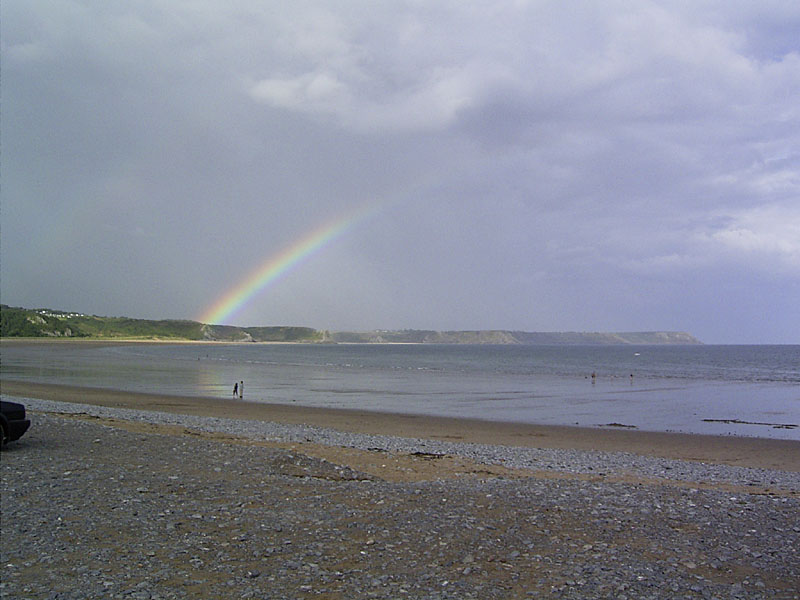
Oxwich
 Oxwich Bay, Gower, South Wales
Oxwich is in the far south of Gower. Attractions include the Oxwich Burrows, the Tudor Oxwich Castle, Penrice Castle and Oxwich Bay.[10][11] The ancient church is dedicated to Saint Illtyd. (Legend says that the stone Baptismal font was placed there by the saint himself.)
Parkmill
Main article: ParkmillParkmill is an inland village between Penmaen and Ilston, on the northern side of the A4118 road, the main road between Swansea and Port Eynon, in a wooded valley. It once lay within Parc le Breos, a deer park established in the 1221–32 CE by John de Braose, Marcher Lord of Gower.
Penclawdd
Main article: PenclawddPenclawdd is in the north of the peninsula. It is one of the larger villages in Gower. Part of the village is perched on a high location, enjoying panoramic views over the Loughor estuary and Gower country, while the main part of the village stretches along the edge of the estuary. It is plentiful in birdlife, and wild horses roam the estuary. Penclawdd is famous for its local cockle industry, which goes back for many years to Roman times.
(It is in Swansea's Penclawdd electoral ward.)
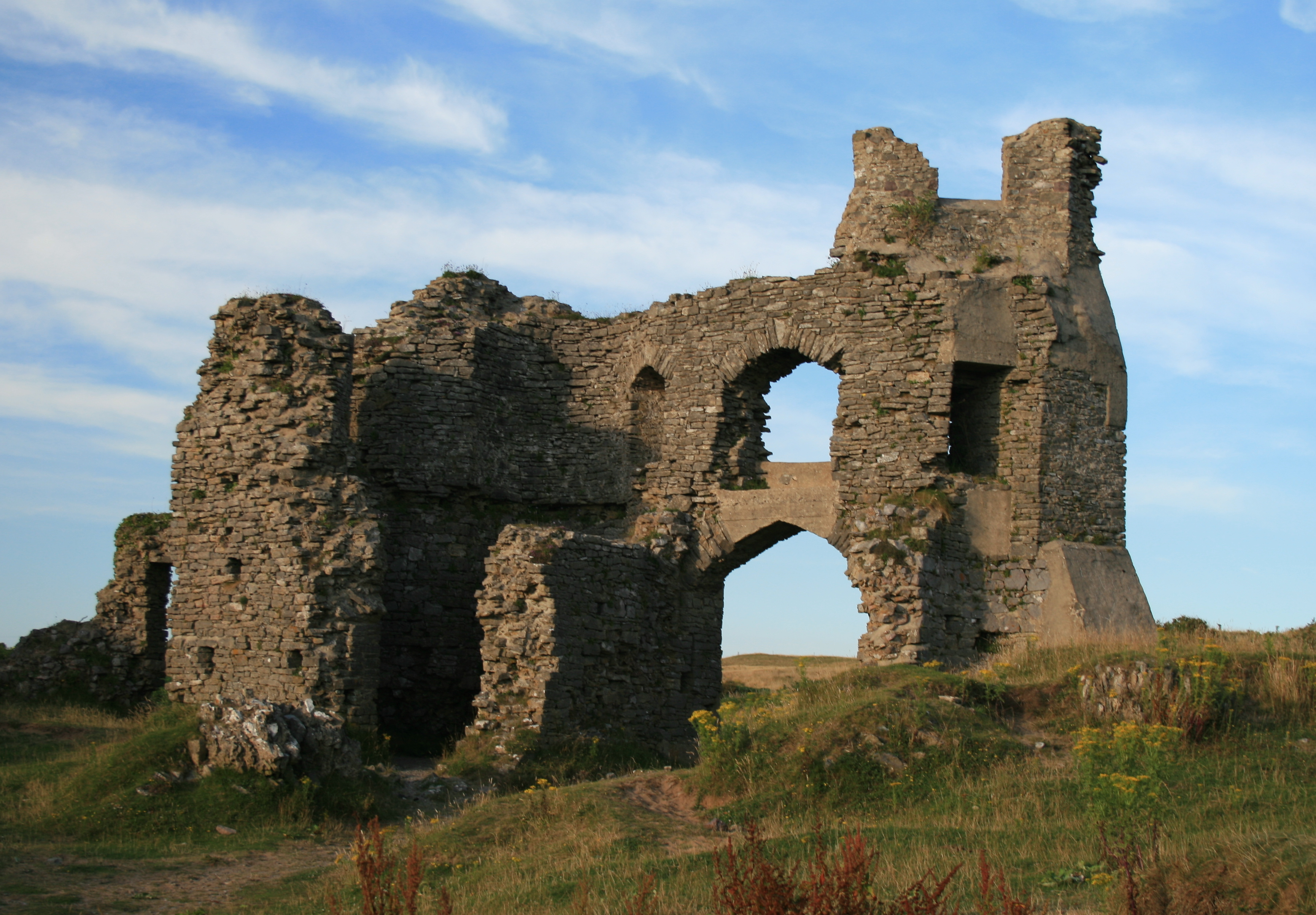
Pennard
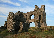 Pennard Castle
Pennard is on the south of the peninsula, about 7 miles south west of Swansea city centre. (It falls within the Pennard ward of Swansea.) It has a church, a primary school and a golf course. It contains the ruins of Pennard Castle. The poet Vernon Watkins (27 June 1906 — 8 October 1967) is buried at Pennard.
Penmaen
Penmaen is an inland village - a scatter of houses around the A4118 road at the foot of the slopes of Cefn Bryn. There are a number of archaeological sites in the area. It contains Parc-Le-Breos, a 19th century hunting lodge, that was once the deer park of William de Breos, Lord of Gower, but today serves as a hotel and pony-trekking centre.
Penmaen Castle began as a small timber castle. Later it was replaced by a stone structure. The dates of the structures are not known but the ringwork and timber gateway is accepted as being Norman. The timber gateway was destroyed by fire and later replaced by a drystone walled gate tower. It is believed that the replacement could either have been built by a Norman or the Welsh lord Rhys Gryg ap Rhys, who had destroyed all the castles in Gower in 1217.
Port Eynon
Main article: Port EynonThis small, south coast village, extending from Port Eynon beach to the top of a hill, has two fish and chip shops at the sea front, a youth hostel, a pub, a coffee shop and a restaurant.
To the north-west lies Overton village, with footpaths to Overton Mere, a rocky beach. Half a mile to the east of the main beach stands the village of Horton.
Reynoldston
Reynoldston is an inland village. It has its own elected community council.
It had one of the longest functioning community broadband schemes in Britain; which started in 2003 and finished at the end of 2008 following the availability of ADSL. It may come back in 2011 but with Optical fiber instead of wireless network; and to promote this idea a "better bordband roadshow" has been orgnised.[12][13] [14]
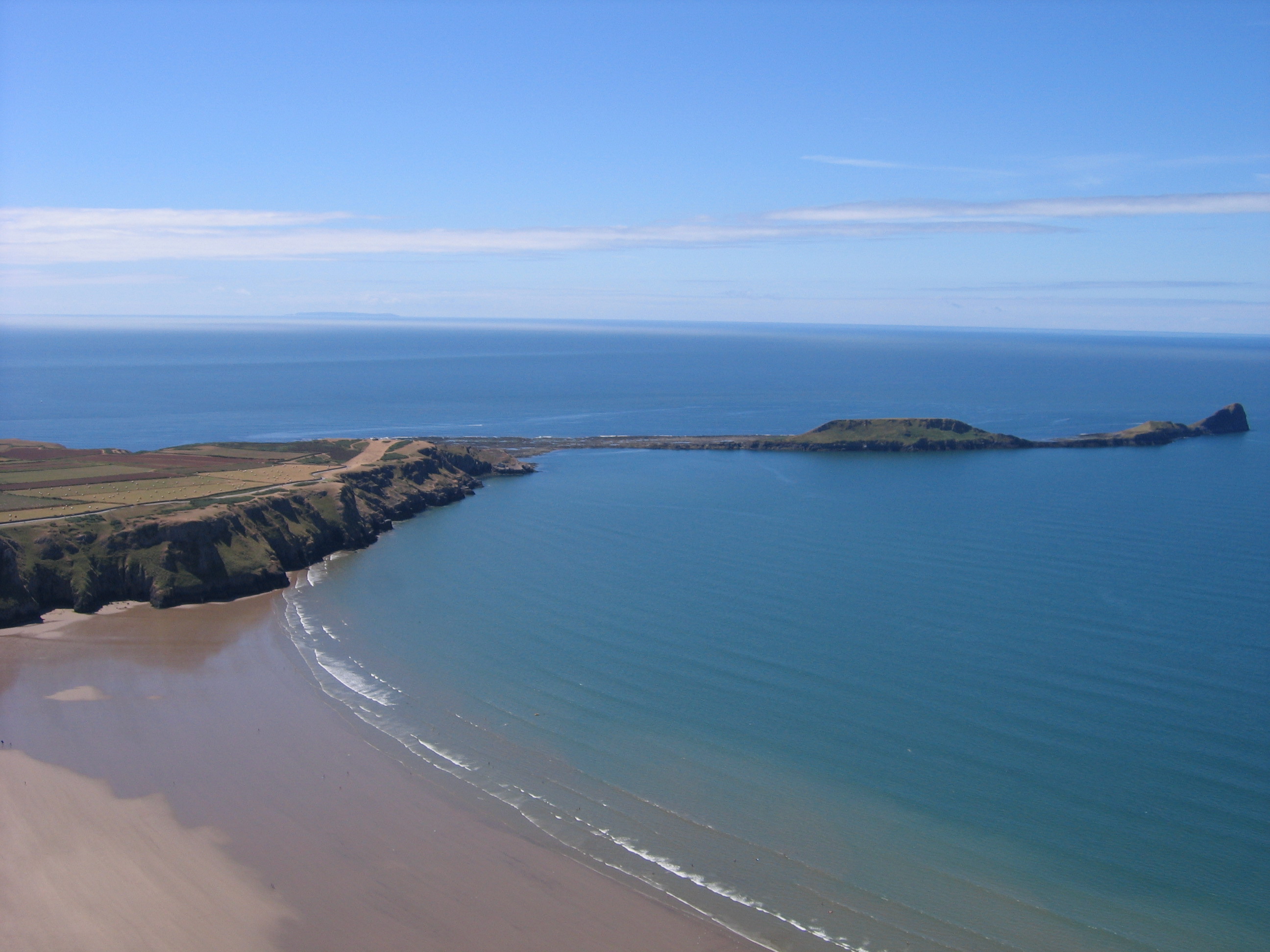
Rhossili
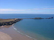 Worm's Head at RhossiliMain article: Rhossili
Rhossili is on the southwestern tip of the peninsula. Since the 1970s it has fallen within the boundaries of Swansea.[15] The village has a community council and is part of the Gower parliamentary constituency, and the Gower electoral ward.
Slade
Slade is situated near the south coast, north west of Oxwich Bay. Points of interest include Eastern Slade Farm, a dairy farm and campsite.
The nearby Slade Bay includes a small beach, and is a breeding ground for fish such as rays, dogfish, common dab and bass.
Three Crosses
Three Crosses (Welsh: Y Crwys) is an inland village at the north east of the peninsula. Situated at a crossroad on the road from Swansea city centre (10 km) to Penclawdd (5 km), it grew up in the early 19th century to serve small shallow collieries in the area. These collieries had disappeared by the early years of the 20th century, and since then Three Crosses has developed as a 'dormitory village' for Swansea. (For administration it is part of Llanrhidian Higher community in the City and County of Swansea.) Three Crosses is home to Capel Y Crwys, a large independent chapel.
Upper Killay
Upper Killay is an inland village. It has its own elected community council.[16] The Clyne Valley cycle track passes though the village. Upper Killay is a gateway to Gower from the east. The main road through the village passes over a cattle grid to the west, which marks the start of Fairwood Common. The village has its own rugby team, Swansea Uplands RFC. Their clubhouse and playing fields are to the south of the village, on Fairwood Common.
Notable residents include Andrew Jones (filmmaker).
Small communities
- Burry Green is a hamlet on the junction between the north Gower road (from Swansea to Llangenydd) and the road south to Port Eynon and Rhosili on the south Gower coast. The latter road forms the shortest road link between Rhosili and Llangenydd. It is a little over a mile north west of Reynoldston[17], and is not far from the Burry Stream, which runs north into the Loughor estuary. The large village green faces the north-eastern slopes of Cefn Bryn, the second-highest point in Gower. Footpaths lead north across Ryers Down to Cheriton.
- Caswell village rises above Caswell Bay, one of the most popular bays in south Gower.51°34′16″N 4°01′04″W / 51.57115°N 4.01787°W
- Horton is a south Gower village, situated just north east of Port Eynon off the A4118 road. Steep lanes descend to sea level, where there are dunes and firm sands, and where visitors may enjoy good bathing, canoeing, fishing and walking. Footpaths lead west to Port Eynon, and east to Slade Bay, Lucas Bay, Oxwich Point and Oxwich. 51°33′12.00″N 4°12′06.00″W / 51.55333°N 4.20167°W
- Kittle is an inland community, next to Bishopston, spreading north and south of the Pennard Road. (It is in Swansea's Pennard electoral ward.) 51°35′03.00″N 4°03′35.00″W / 51.58417°N 4.05972°W
- Knelston is an inland settlement on a conspicuous rise one mile south-west of Reynoldston. (It is in the Gower ward.)[18]51°34′46.00″N 4°12′53.00″W / 51.57944°N 4.21472°W In neighboring fields may be found ruins of a 12th-century church of St Taurin, and three standing stones.
- Landimore is a north Gower hamlet, descending to salt marshes east of Cheriton. It is in the Gower ward between Llanmadoc and Llanrhidian. On the slopes of a hill to the west are traces of Landimore castle (also known as Bovehill castle).
- Langland village, near the south Gower coast, adjoins the popular Langland Bay beach resort. It is in the Newton and Oystermouth wards.[19]51°34′11.00″N 4°00′12.00″W / 51.56972°N 4.00333°W
- Llandewi or Llanddewi is an inland hamlet, on the road linking the north Gower villages of Llangenydd, Llanmadoc and Llanrhidian with the south Gower villages of Port Eynon and Rhosili. It is in the Port Eynon community council area, approximately 2 miles south west of Reynoldston and 3 miles north of Rhossili.[20] The church of St. David was built by Henry de Gower between 1328 and 1347. Its tower contains an 18th-century bell.[21] 51°34′46.00″N 4°13′25.00″W / 51.57944°N 4.22361°W
- Llethryd (or Llethrid) is an inland farming settlement, near the centre of Gower, around the B4271 road out of Swansea, just over halfway between Upper Killay and Llanrhidian, and on the western edge of Pengwern common. Here the road descends steeply into a little wooded valley, through which flows the stream of Parkmill Pill. About 200 yards south of the road lies the entrance to the vast Llethryd Tooth Cave.
- Middleton lies on the south-west edge of Gower, on the outskirts of Rhosili village and not far from Rhossili Bay. It has a much-used village hall. Lanes lead south to Fall Bay and Mewslade, and north across Rhosili Down to Llangenydd.
- Nicholaston is a farming community near the south coast of Gower, on the road between Penmaen and Oxwich. It is in the Gower ward.[22] The isolated church of St Nicolas was built in the 14th century, but was thoroughly reconstructed in 1894. Its alabaster pulpit incorporates sculptures of the 19th-century theologians Keble, Liddon and Pusey.
- Oldwalls, on the north Gower road, a little west of Llanrhidian, consists of a small number of houses and a holiday accommodation site. [23]
- Overton in south Gower is a secluded hamlet overlooking Port Eynon. It is in the Gower ward. Footpaths lead south to the pebbly beach of Overton Mere, and west along the cliffs to Paviland and Rhosili.
- Oxwich Green in south Gower is a farming settlement on the road between the villages of Oxwich and Slade.
- Penrice, a hamlet in south Gower, inland from Oxwich Bay, is approachable by steep, narrow roads. On its village green - once a social centre of Gower - stand the church of St Andrew and the stone base of a former cross. Penrice Park contains an 18th-century country-house and the remains of a Norman castle - both known as Penrice Castle.
- Pitton is a sheltered settlement in south-west Gower, near Rhosili, centred on Great Pitton Farm, one of the oldest farms in Gower. It is in the Gower ward. In the 18th century some villagers were involved in smuggling. Lanes lead south from Pitton Hill to the sea at Mewslade, and north across Rhosili Downs to Llangenydd.
- Pitton Green consists of a few houses on the road connecting the villages of Scurlage and Rhossili.
- Scurlage in southern Gower lies at the junction of roads leading to Port Eynon or Rhosili. It has a sports field and a caravan site. Some walls of Scurlage castle may be seen.
- Southgate is on the cliffs of south Gower, within the Pennard ward of Swansea. It is near Penard golf links. Footpaths lead to Pobbles and Three Cliffs Bay.
References
- ^ Tourism Info
- ^ Cheriton Info and Photos
- ^ Gowerton local history
- ^ CADW: Historic Landscape Characterisation: Ilston
- ^ St. Madoc's Church Llanmadoc
- ^ "GOWER/GWYR". www.someplacenamesinsouthwales.4t.com. http://www.someplacenamesinsouthwales.4t.com/rich_text.html. Retrieved 2010-01-10.
- ^ St. Rhidian & St. Illtyd Church, Llanrhidian
- ^ Bishopston Ward Profile
- ^ Murton Methodist Church
- ^ Holiday & background information on the village of Oxwich
- ^ The Travel Magazine's 12 Best Beaches 2007 (July is Oxwich)
- ^ The Reynoldston Village Community web site
- ^ Reynoldston on GowerCoast.com
- ^ [1]
- ^ A Guide to Gower, published by the Gower Society, ISBN 0-902767-23-2
- ^ "Upper Killay Community Council, Swansea". www.gowercc.org.uk. http://www.gowercc.org.uk/upperkillay/upperkillayhome.php. Retrieved 2010-01-10.
- ^ "Burry Holiday Cottages. Self-catering cottages in the Gower Peninsula, Swansea, South Wales.". www.burrycottages.co.uk. http://www.burrycottages.co.uk/. Retrieved 2010-01-10.
- ^ Gower Ward Profile
- ^ Newton Ward Profile
- ^ Historical information at GENUKI
- ^ Llandewi Church: St. David's Church
- ^ "Penmaen and Nicholaston. The villages of Penmaen and Nicholaston, The Gower Peninsula, South Wales". www.the-gower.com. http://www.the-gower.com/villages/Penmaen/penmaen.htm. Retrieved 2010-01-10.
- ^ "Oldwalls Leisure Ltd. - Luxury Accommodation - Gower - Swansea - Location". www.oldwallsleisure.com. http://www.oldwallsleisure.com/about-oldwalls/location.html. Retrieved 2010-01-10.
External links
- Gower Community Councils
- Place names of Gower
- The Gower Community: Penmaen
- Penmaen and Nicholaston
- Castle Wales: Penmaen Castle
- Fookes: Penmaen, Gower Peninsula
- Parc-Le-Breos
Geographical areas Beaches
listed clockwiseBracelet Bay • Limeslade Bay • Rotherslade • Langland Bay • Caswell Bay • Brandy Cove • Pwlldu Bay • Hunts Bay • Pobbles Bay • Three Cliffs Bay • Tor Bay • Oxwich Bay • Slade Bay • Horton Beach • Port Eynon Beach • Mewslade Bay • Fall Bay • Rhossili Bay (Llangennith Sands) • Burry Holms • Blue Pool Bay • Broughton Bay • Whiteford Sands
Villages in Gower Bishopston • Burry Green • Caswell • Cheriton • Crofty • Gowerton • Horton • Ilston • Kittle • Knelston • Landimore • Langland • Llanddewi • Llangennith • Llanmadoc • Llanmorlais • Llanrhidian • Llethryd • Middleton • Murton • Newton • Nicholaston • Oldwalls • Overton • Oxwich • Oxwich Green • Parkmill • Penclawdd • Pennard • Penmaen • Penrice • Pitton • Pitton Green • Port Eynon • Reynoldston • Rhossili • Slade • Scurlage • Southgate • Three Crosses • Upper Killay
Prehistoric sites Arthur's Stone • Parc Cwm long cairn • Paviland Cave
Castles Loughor Castle • Oxwich Castle • Oystermouth Castle • Pennard Castle • Penrice Castle
Lighthouses Mumbles Lighthouse • Whiteford Lighthouse
Cuisine of Gower • Gower Society • Gower Ornithological Society • Parc le BreosCategories:- Villages in Swansea
- Gower Peninsula
Wikimedia Foundation. 2010.