- Manhattan Community Board 2
-
 Community Board 2
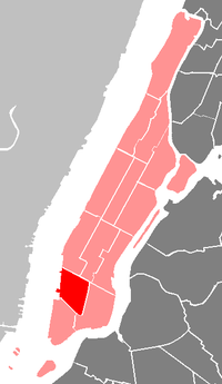
The Manhattan Community Board 2 is a local government unit of New York City, encompassing the neighborhoods of Greenwich Village, West Village, NoHo, SoHo, Lower East Side, Chinatown, and Little Italy in the borough of Manhattan. It is delimited by Bowery on the east, Canal Street on the south, the Hudson River on the west and 14th Street on the north. The district covers three city council districts, four police precincts, and encompasses one of the largest landmark districts in New York City.
Due to overwhelming disgust with the impending overdevelopment of Greenwich Village during the late 1950s and early 1960s, residents organized to fight further destruction of historic buildings and townhouses within the village. These residents made up the first members of what was then called a "Community Planning Board." CB2 was one of the very first of these "Community Planning Boards."
The board's District Manager is Bob Gormley.[1] He administers the Board office and is the principal liaison with various City agencies involved in CB2 affairs. He further chairs the monthly District Service Cabinet meeting at which representatives from various City agencies and elected officials address issues of concern within the community. The District Manager additionally oversees the Board operating budget expenditures and prepares drafts as well as the annual report submitted to the Mayor and the City Council. Mr. Gormley reports on all of these matters at the monthly CB#2 Executive Committee meeting.
Demographics
At the 2000 United States Census, the Community Board had a population of 93,119 (down from 94,105 in 1990 but up from 87,069 in 1980). 69,683 (74.8%) were White non Hispanic, 2,226(2.4%) were African American, 13,622 (14.6%) Asian or Pacific Islander, 74 (0.1%) American Indian or Native Alskan, 324 (0.3%) of some other race, 1,860 (2.0%) of two or more races, 5,290 (5.7%) of Hispanic origins. 10.7% of the population benefited from public assistance in 2010, up from 5.2 in 2000.[2]
The land area is 866.4 acres, or 1.4 square miles (3.6 km2).[2]
References
- ^ "Manhattan Community Board 2: About Community Board 2". The City of New York. http://www.nyc.gov/html/mancb2/html/home/home.shtml. Retrieved 24 April 2011.
- ^ a b "Manhattan Community Board 2 Profile". The City of New York. http://nyc.gov/html/dcp/pdf/lucds/mn2profile.pdf. Retrieved 24 April 2011.
External links
Community Boards of New York City Manhattan The Bronx Brooklyn Queens Staten Island Categories:- Manhattan Community Boards
- New York City stubs

Wikimedia Foundation. 2010.