- Liberty Island
Infobox Islands
name = Liberty
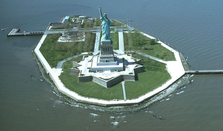
image caption = Liberty Island
image size = 250px
locator
Location map|USA New York City|lat=40.689848|long=-74.045298
map_custom = yes
native name =
native name link =
nickname =
location =Upper New York Bay
coordinates = coord|40.689848|N|74.045298|W|display=inline
archipelago =
total islands =
major islands =
area = convert|14.717|acre|m2|abbr=on
length =
width =
highest mount =
elevation =
country = United States
country admin divisions title = State
country admin divisions = flag|New York
country admin divisions title 1 =
country admin divisions 1 =
country admin divisions title 2 =
country admin divisions 2 =
country largest city =
country largest city population =
population =
population as of =
density =
ethnic groups =
additional info =Liberty Island, formerly called Bedloe's Island, is a small uninhabited island in
Upper New York Bay in the United States, best known as the location of theStatue of Liberty . The name Liberty Island has been in use since the early 20th century, although the name was not officially changed until 1956. Before the Statue of Liberty, Bedloe's Island was the home toFort Wood , an eleven pointed star-shapedfortification made of granite. Because of this, its nickname was "Star Fort".The island is the property of the federal government and is operated by the
National Park Service . It is accessible to the public only by ferry, either fromBattery Park inManhattan orLiberty State Park inJersey City, New Jersey . It is separated from nearbyEllis Island by approximately 1 mi (1.6 km).Liberty Island is 2000 feet (600 m) from Liberty State Park in Jersey City, New Jersey. By comparison it is 1-5/8 statute miles (2.6 kilometers) from Battery Park in Manhattan; this makes Liberty Island much closer to Jersey City, New Jersey than to the rest of
New York City , of which it is a part. The island has a land area of 59,558 square meters, or 14.717acres , according to theUnited States Census Bureau .Since September 11, 2001, the waters surrounding the island are guarded by around-the-clock patrols of the United States Park Police Marine Patrol Unit.
Bedloe's Island
Quarantine law began in Colonial America in 1663, when in an attempt to curb an outbreak of
smallpox , the city of New York established a quarantine. In the 1730s, the city built aquarantine station on the island.cite web |url= http://www.ushistory.org/laz/history/index.htm |title=Lazaretto Quarantine Station, Tinicum Township, Delaware County, PA: History |accessdate= 2008-04-24 |last= |first= |coauthors= |date= |work= |publisher=ushistory.org ]Relationship to New York and New Jersey
Liberty Island is within the territorial jurisdiction of the State of New York, a status that was established in 1664, reaffirmed in 1834, and which has never been officially disputed. The island has been owned by the federal government since 1800. However, Liberty Island is actually a part of The State of New Jersey.
The belief that Liberty Island is "in"
New Jersey is derived from these facts:
*Liberty Island's proximity to Jersey City;
*Its appearance on maps on the New Jersey side of the state line;
*New Jersey's victory in a 1998 lawsuit with New York over the ownership of parts ofEllis Island .
*New Jersey's provision of all utility services, including electricity, water, and sewage, to Liberty and Ellis islandsThe Statue of Liberty itself is claimed as a symbol by both New York and New Jersey. It was featured on New York State's [http://www.worldlicenceplates.com/usa/US_NYXX.html license plates] from 1986 through 2000 and on a special [http://www.state.nj.us/mvc/images/liberty.gifNew Jersey license plate] celebrating Liberty State Park in Jersey City. The Statue is also seen on the New York State Quarter.
It is indisputable that maps draw the boundary between New Jersey and New York in the center of the Hudson River, with Liberty Island situated well on the New Jersey side of the line. The State of New Jersey in fact does retain the riparian rights to all the "submerged" land surrounding the statue, extending eastward to the boundary line. New Jersey has never claimed any legal rights to the dry land of Liberty Island.
The islands of New York harbor have been part of New York since the issuance in 1664 of the colonial charter that created New Jersey (see [http://www.yale.edu/lawweb/avalon/states/nj01.htm charter text] ). This charter stated that New Jersey "bounded by the Hudson River" rather than from the middle channel, as was common in other colonial charters. That is, as everyone understood at the time, the New York-New Jersey border did not go through the center of the river channel as one might naturally assume. An 1834 compact between New York and New Jersey, which primarily concerned the status of Staten Island, set the boundary line between the States as the middle of the Hudson River but reaffirmed that Staten Island and the other islands belonged to New York.The Ellis Island lawsuit concerned a special situation. Ellis Island is mostly constructed of artificial infill. New Jersey argued and the court agreed that the 1834 compact covered only the natural parts of the island, and not the portions added by infill. Thus it was agreed that the parts of the island made of filled land belonged to New Jersey while the original natural part belonged to New York. (This proved impractical to administer and New Jersey and New York subsequently agreed to share jurisdiction of the entire island). This special situation only applies to Ellis Island and part of Shooter's Island. The natural islands such as Staten Island, Liberty Island, and Prall's Island were not and are not in dispute.
Question 127 on a naturalization examination piloted in 2006 asks "Where is the Statue of Liberty?" The U. S. Citizenship and Immigration Services gives "New York Harbor" and "Liberty Island" as preferred answers, but notes that "New Jersey," "near New York City," and "on the Hudson" are acceptable. [cite web|url=http://www.uscis.gov/portal/site/uscis/menuitem.5af9bb95919f35e66f614176543f6d1a/?vgnextoid=dcf5e1df53b2f010VgnVCM1000000ecd190aRCRD|title=Questions and Answers for New Pilot Naturalization Exam|accessdate=2006-12-01|date=2006-11-30|publisher=U. S. Citizenship and Immigration Services]
According to the USGS, Liberty Island is located in New York's 8th Congressional District.
ee also
*
Statue of Liberty
*The Statue of Liberty in popular culture External links
* [http://local.google.com/local?q=40.690+-74.045&t=h&iwloc=A&hl=en Liberty Island Aerial View]
* [http://www.cr.nps.gov/history/online_books/hh/11/hh11m.htm National Park Service Bedloe's Island web site]
* [http://www.nps.gov/stli/ National Park Service's Statue of Liberty and Liberty Island site]
* [http://www.hudsonlights.com/liberty.htm Statue of Liberty Lighthouse] Notes on territorial history and status of Liberty island
* [http://factfinder.census.gov/servlet/DTTable?_bm=y&-show_geoid=Y&-tree_id=4001&-_showChild=Y&-context=dt&-errMsg=&-all_geo_types=N&-mt_name=DEC_2000_SF1_U_P001&-redoLog=false&-transpose=N&-search_map_config=|b=50|l=en|t=4001|zf=0.0|ms=sel_00dec|dw=0.021322492709908183|dh=0.012115860287740017|dt=gov.census.aff.domain.map.EnglishMapExtent|if=gif|cx=-74.03690863547648|cy=40.6940066243844|zl=2|pz=2|bo=318:317:316:314:313:323:319|bl=362:393:358:357:356:355:354|ft=350:349:335:389:388:332:331|fl=381:403:204:380:369:379:368|g=04000US36&-PANEL_ID=p_dt_geo_map&-_lang=en&-geo_id=15000US360610001009&-CONTEXT=dt&-format=&-search_results=100$10000US360610001009000&-ds_name=DEC_2000_SF1_U Liberty Island: Block Group 9, Census Tract 1, New York County, United States Census Bureau]References
Wikimedia Foundation. 2010.