- Chiguayante
-
Chiguayante — City and Commune — 
Coat of armsLocation of Chiguayante commune in the Biobío Region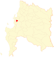 Location in Chile
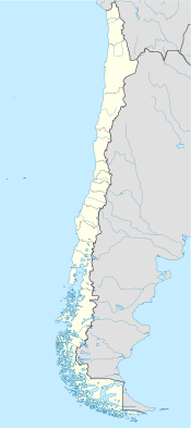
 Chiguayante
Coordinates: 36°55′S 73°01′W / 36.917°S 73.017°WCoordinates: 36°55′S 73°01′W / 36.917°S 73.017°W Country Chile Region Biobío Province Concepción Government[1][2] - Type Municipality - Alcalde Tomás Solis Nova (PS) Area[3] - Total 71.5 km2 (27.6 sq mi) Population (2002 Census)[3] - Total 81,302 - Density 1,137.1/km2 (2,945.1/sq mi) - Urban 81,238 - Rural 64 Demonym Chiguayantino Sex[3] - Men 38,524 - Women 42,778 Time zone CLT (UTC−4) - Summer (DST) CLST (UTC−3) Area code(s) 56 + 41 Website Municipality of Chiguayante Chiguayante is a Chilean city and commune in Concepción Province, Biobío Region. It is part of Greater Concepción.
Contents
Demographics
According to the 2002 census of the National Statistics Institute, Chiguayante spans an area of 71.5 km2 (28 sq mi) and has 81,302 inhabitants (38,524 men and 42,778 women). Of these, 81,238 (99.9%) lived in urban areas and 64 (0.1%) in rural areas. The population grew by 44.2% (24,931 persons) between the 1992 and 2002 censuses.[3] It had an estimated 2010 population of 119,265.[citation needed]
Administration
As a commune, Chiguayante is a third-level administrative division of Chile administered by a municipal council, headed by an alcalde who is directly elected every four years. The 2008-2012 alcalde is Tomás Solis Nova (PS).[1][2]
Within the electoral divisions of Chile, Chiguayante is represented in the Chamber of Deputies by José Miguel Ortiz (PDC) and Enrique Van Rysselberghe (UDI) as part of the 44th electoral district, (together with Concepción and San Pedro de la Paz). The commune is represented in the Senate by Alejandro Navarro Brain (MAS) and Hosain Sabag Castillo (PDC) as part of the 12th senatorial constituency (Biobío-Cordillera).
References
- ^ a b (Spanish) "Asociación Chilena de Municipalidades". http://www.chiguayante.cl/. Retrieved 7 February 2011.
- ^ a b (Spanish) "Municipality of Chiguayante". http://www.chiguayante.cl/. Retrieved 7 February 2011.
- ^ a b c d (Spanish) "National Statistics Institute". http://www.ine.cl/canales/chile_estadistico/censos_poblacion_vivienda/censo_pobl_vivi.php. Retrieved 13 December 2010.
External links
- (Spanish) Municipality of Chiguayante
Cities Concepción · Talcahuano · Chiguayante · San Pedro de la Paz · Hualpén · Penco · Tomé · Coronel · Lota · HualquiUniversities Culture & Sports El Sur · C.D. Universidad de Concepción · Fernández Vial · Deportes Concepción · C.D. Huachipato · Lota SchwagerChilean cities with a population of over 150,000 (2002) Greater Santiago (Puente Alto, Maipú, La Florida, Las Condes, San Bernardo, Peñalolén, Santiago, Pudahuel, La Pintana, El Bosque, Ñuñoa) · Greater Valparaíso (Valparaíso, Viña del Mar) · Greater Concepción (Concepción, Talcahuano) · Greater La Serena (La Serena, Coquimbo) · Antofagasta · Greater Temuco · Greater Rancagua · Greater Talca · Arica · Greater Chillán · Copiapó · Iquique · Osorno · Puerto Montt
< Communes and municipalities in Biobío Region > Ñuble Province Bulnes · Chillán · Chillán Viejo · Cobquecura · Coelemu · Coihueco · El Carmen · Ninhue · Ñiquén · Pemuco · Pinto · Portezuelo · Quillón · Quirihue · Ránquil · San Carlos · San Fabián · San Ignacio · San Nicolás · Treguaco · Yungay
Concepción Province Concepción · Coronel · Chiguayante · Florida · Hualpén · Hualqui · Lota · Penco · San Pedro de la Paz · Santa Juana · Talcahuano · ToméBiobío Province Alto Biobío · Antuco · Cabrero · Laja · Los Ángeles · Mulchén · Nacimiento · Negrete · Quilaco · Quilleco · San Rosendo · Santa Bárbara · Tucapel · YumbelArauco Province Categories:- Communes of Chile
- Populated places in Concepción Province


Wikimedia Foundation. 2010.