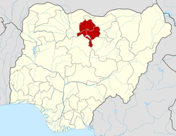
- Kano State
-
Kano State — State — 
SealNickname(s): Centre of Commerce Location of Kano State in Nigeria Coordinates: 11°30′N 8°30′E / 11.5°N 8.5°ECoordinates: 11°30′N 8°30′E / 11.5°N 8.5°E Country  Nigeria
Date created May 27, 1967 Capital Kano Government – Governor[1] Rabiu Kwankwaso (People's Democratic Party) – Senators - Bello Hayatu Gwarzo
- Mohammed Adamu Bello
- Kabiru Ibrahim Gaya
– Representatives List Area – Total 20,131 km2 (7,772.6 sq mi) Area rank 20th of 36 Population (2006 census)1 (population disputed) – Total 13,383,682 – Rank 1st of 36 – Density 664.8/km2 (1,721.9/sq mi) GDP (PPP) – Year 2007 – Total $12.39 billion[2] – Per capita $1,288[2] Time zone WAT (UTC+01) ISO 3166 code NG Website kanostate.net ^1 Preliminary results Kano State is a state located in North-Western Nigeria. Created on May 27, 1967 from part of the Northern Region, Kano state borders Katsina State to the north-west, Jigawa State to the north-east, Bauchi State to the south-east and Kaduna State to the south-west. The capital of Kano State is Kano.
The state originally included Jigawa State which was made a separate state in 1991.
Contents
Economy and society
Historically, Kano State has been a commercial and agricultural state, which is known for the production of groundnuts as well as for its solid mineral deposits. The state has more than 18,684 square kilometres (7,214 sq mi) of cultivable land and is the most extensively irrigated state in the country.[citation needed]
Kano State has in recent years being a centre of religious and ethnic violence in Nigeria. It also opposed the polio vaccination programme.
Foreign investments and investors can be seen all over the city. It is arguably within the first five states in terms of commercial activity within Nigeria. Kano also has traditionally received the largest proportion of centrally collected (mostly oil) revenues. From 1990-96 Kano received 10.9% of allocated revenue. In contrast, the next highest state was Sokoto State, receiving 3.5%, with Abuja, Lagos State, and Akwa Ibom State receiving 3.2% each.[3]
Kano's once booming manufacturing sector has been stagnant over the last 15 years. Largely due to epileptic[ambiguous] power supply. Plans are being considered to build a Nuclear Power Station in the North-Eastern region of Nigeria. The plant is to be fueled from Uranium mined in neighbouring Gombe state and supplied over a rail network.
Local Government Areas
The state is home to 44 Local Government Areas (LGAs):
LGA Name Area (sq.km) Census 2006
populationAdministrative capital Postal
CodeDala 19 1,418,777 Gwamaja 700 Fagge 21 698,828 Waje 700 Gwale 18 562,059 Gwale 700 Kano Municipal 17 665,525 Kofar Kudu 700 Tarauni 28 321,367 Ungwa Uku 700 Nassarawa 34 696,669 Bompai 700 Kumbotso 158 395,979 Kumbotso 700 Ungogo 204 469,657 Ungogo 700 Kano Metropolitan Area 499 3,628,861 700 Dawakin Tofa 479 247,875 Dawakin Tofa 701 Tofa 202 97,734 Tofa 701 Rimin Gado 225 104,790 Rimin Gado 701 Bagwai 405 162,847 Bagwai 701 Gezawa 340 282,069 Gezawa 702 Gabasawa 605 211,055 Zakirai 702 Minjibir 416 213,794 Minjibir 702 Dambatta 732 207,968 Dambatta 702 Makoda 441 222,399 Koguna 702 Kunchi 671 111,018 Kunchi 703 Bichi 612 277,099 Bichi 703 Tsanyawa 492 157,680 Tsanyawa 703 Shanono 697 140,607 Shanono 704 Gwarzo 393 183,987 Gwarzo 704 Karaye 479 141,407 Karaye 704 Rogo 802 227,742 Rogo 704 Kabo 341 153,828 Kabo 704 Northern Kano State 8,332 3,143,899 701 to 704 Bunkure 487 170,891 Bunkure 710 Kibiya 404 136,736 Kibiya 710 Rano 520 145,439 Rano 710 Tudun Wada 1,204 231,742 Tudun Wada 710 Doguwa 1,473 151,181 Riruwai 710 Madobi 273 136,623 Madobi 711 Kura 206 144,601 Kura 711 Garun Mallam 214 116,494 Garun Mallam 711 Bebeji 717 188,859 Bebeji 711 Kiru 927 264,781 Kiru 711 Sumaila 1,250 253,661 Sumaila 712 Garko 450 162,500 Garko 712 Takai 5989 202,743 Takai 712 Albasu 398 190,153 Albasu 712 Gaya 613 201,016 Gaya 713 Ajingi 714 174,137 Ajingi 713 Wudil 362 185,189 Wudil 713 Warawa 360 128,787 Warawa 713 Dawakin Kudu 384 225,389 Dawakin Kudu 713 Southern Kano State 11,554 3,410,922 710 to 713 Languages
The official language of Kano State is English but the Hausa language is commonly spoken. Ibrahim Ado-Kurawa (2003). "Brief History of Kano 999 to 2003". http://www.kanostate.net/. Kano State Government Nigeria. http://www.kanostate.net/profile.html. Retrieved 2009-12-07.
Population
According to the 2006 census figures from Nigeria Kano State had a population totalling 9,383,682. The credibility of the census has been disputed most noticeably by Gani Fawehinmi – a Lagos-based advocate and activist.[4] The state is mostly populated by Hausa people.[5]
See also
References
- ^ See List of Governors of Kano State for a list of prior governors
- ^ a b "C-GIDD (Canback Global Income Distribution Database)". Canback Dangel. http://www.cgidd.com. Retrieved 2008-08-20.
- ^ Urban Policy in the New Scotland: The Role of Social Inclusion Partnerships - Space and Polity
- ^ [1][dead link]
- ^ http://www.onlinenigeria.com/map.gif
External links
 States of Nigeria
Abia · Abuja Federal Capital Territory · Adamawa · Akwa Ibom · Anambra · Bauchi · Bayelsa · Benue · Borno · Cross River · Delta · Ebonyi · Edo · Ekiti · Enugu · Gombe · Imo · Jigawa · Kaduna · Kano · Katsina · Kebbi · Kogi · Kwara · Lagos · Nasarawa · Niger · Ogun · Ondo · Osun · Oyo · Plateau · Rivers · Sokoto · Taraba · Yobe · Zamfara
Audu Bako • Sani Bello • Ishaya Shekari • Abubakar Rimi • Abdu Dawakin Tofa • Sabo Bakin Zuwo • Hamza Abdullahi • Ahmed Muhammad Daku • Mohammed Ndatsu Umaru • Idris Garba • Kabiru Ibrahim Gaya • Muhammadu Abdullahi Wase • Dominic Oneya • Aminu Isa Kontagora • Rabiu Musa Kwankwaso • Ibrahim ShekarauCategories:- States of Nigeria
- Kano State
- States and territories established in 1967
Wikimedia Foundation. 2010.

