- Dambatta
-
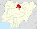
Dambatta — LGA and town — Location in Nigeria Coordinates: 12°25′59″N 8°30′55″E / 12.43306°N 8.51528°ECoordinates: 12°25′59″N 8°30′55″E / 12.43306°N 8.51528°E Country  Nigeria
State Kano State Area – Total 732 km2 (282.6 sq mi) Population (2006 census) – Total 207,968 Time zone WAT (UTC+1) 3-digit postal code prefix 702 ISO 3166 code NG.KN.DM Dambatta (or Dambarta) is a Local Government Area in Kano State, Nigeria. Its headquarters are in the town of Dambatta in the west of the area on the A2 highway.
It has an area of 732 km² and a population of 207,968 at the 2006 census. The town is the location for the Audu Bako School of Agriculture.[1]
The postal code of the area is 702.[2]
References
- ^ Steve Packer, Pius Elumeze, M.B. Shitu (October 2006). "State Educational Sector Project: Institutional Assessment - Kano State". ESSPIN. http://www.esspin.org/resources/download/19/kano-institutional-assessment.pdf. Retrieved 2010-05-16.
- ^ "Post Offices- with map of LGA". NIPOST. http://www.nipost.gov.ng/PostCode.aspx. Retrieved 2009-10-20.
 Kano StateState capital: Kano
LGAs Ajingi · Albasu · Bagwai · Bebeji · Bichi · Bunkure · Dala · Dambatta · Dawakin Kudu · Dawakin Tofa · Doguwa · Fagge · Gabasawa · Garko · Garun Mallam · Gaya · Gezawa · Gwale · Gwarzo · Kabo · Kano Municipal · Karaye · Kibiya · Kiru · Kumbotso · Kunchi · Kura · Madobi · Makoda · Minjibir · Nasarawa · Rano · Rimin Gado · Rogo · Shanono · Sumaila · Takai · Tarauni · Tofa · Tsanyawa · Tudun Wada · Ungogo · Warawa · Wudil
 Categories:
- Local Government Areas in Kano State
- Populated places in Kano State
- Nigeria geography stubs
Wikimedia Foundation. 2010.

