- Southern Provinces
-
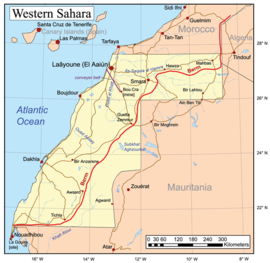 The Southern Provinces are the land west of the red line, which indicates the Moroccan Berm.
Morocco 
This article is part of the series:
Politics and government of
MoroccoConstitutionMonarchyGovernmentJudiciaryDivisions- Administrative divisions
- Regions
- Provinces
- Wilayas
ElectionsForeign policy
Part of a series on the History of Western Sahara 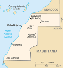
Background History of Morocco (Colonial wars)
Spanish Sahara · Spanish Morocco
Moroccan Army of Liberation
Harakat Tahrir · Sahrawi National Union Party
Madrid AccordsDisputed regions Saguia el-Hamra · Río de Oro
Southern Provinces · Free Zone ·Politics Legal status of Western Sahara · Politics of Morocco / of the SADR
Polisario Front (former members)
Royal Advisory Council for Saharan AffairsRebellions Pre-1975:
Ifni War · Zemla Intifada
post 1975:
Western Sahara War · Independence IntifadaConflict issues Refugee camps · Wall · Human rights in Western Sahara Sahara peace process Resolution 1495 · Resolution 1754 · Visiting mission · Referendum mission · ICJ Advisory Opinion · Settlement Plan · Houston Agreement · Baker Plan · Manhasset negotiations · Moroccan Initiative The Southern Provinces or Moroccan Sahara are the terms used by Morocco for Western Sahara, in reference to the part of Western Sahara that lies to the west of the Moroccan Berm. Following the Madrid Accords signed with Spain and Mauritania in 1975, Morocco took control of Saguia el-Hamra, and the northern part of Rio de Oro, while Mauritania took control of the remaining part of Rio de Oro, renamed as Tiris al-Gharbiyya. A locally based Sahrawi national liberation movement, the Polisario Front launched a guerrilla war, with the backing of the Algeria, aiming to win independence of the territory, which caused Mauritania to pull out in 1979, despite the backing of France.[citation needed] Morocco then proceeded to take control of the remaining parts of Saguia el-Hamra as well.
Since a United Nations-sponsored cease-fire agreement in 1991, most of the territory is at present administered by Morocco. The Polisario Front claims to control most of the remainder, which is almost unpopulated. The cease-fire line corresponds to the route of the Moroccan Wall. Both sides claim the territory in its entirety. The Sahrawi Arab Democratic Republic is recognized by 53 nations, and is a full member of the African Union. Moroccan territorial integrity is explicitly recognized by the Arab League[citation needed]. Administratively, Morocco divided the territory under its control into administrative units (wilayas). Flags and coats of arms were created for the three wilayas of Boujdour,[1] Smara and Laayoune.[2] There were further changes in the territories in 1983, with the area becoming four wilayas through the addition of Dakhla.[3] In 1990 Wadi al-Dhahab (Rio de Oro) was added.
References and notes
- ^ "Boujdour province, Morocco". crwflags.com. http://areciboweb.50megs.com/fotw/flags/ma-bod.html. Retrieved 2007-03-20.
- ^ "Laayoune province, Morocco". crwflags.com. http://areciboweb.50megs.com/fotw/flags/ma-laa.html. Retrieved 2007-03-20.
- ^ "Dakhla (Oued Eddahab-Lagouira) Province, Morocco". crwflags.com. http://areciboweb.50megs.com/fotw/flags/ma-xdk.html. Retrieved 2007-03-20.
External links
Categories:- Geography of Western Sahara
- Geography of Morocco
- Politics of Morocco
- Western Sahara stubs
- North Africa geography stubs
- Morocco geography stubs
- Administrative divisions


Wikimedia Foundation. 2010.