- Moalboal, Cebu
-
Moalboal — Municipality — Country  Philippines
Region Central Visayas (Region VII) Province Cebu District Government - Mayor Population (2007) - Total 27,398 Time zone PHT (UTC+8) ZIP Code Website - Moalboal is a 3rd class municipality in the province of Cebu, Philippines. According to the 2007 census, it has a population of 27,398 people.
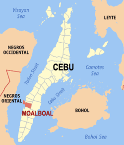
Extending as a peninsula in the Southwestern tip of Cebu, Moalboal is bordered to the west by the Tañon Strait. From the western shoreline, the island of Negros can be seen. Moalboal is located 89 kilometers from Cebu City, about 2.5 hours by bus.
Moalboal is nestled between the towns of Alcantara and Badian. From the tulay, an unfinished bridge located in Moalboal's town proper, Badian Island can be clearly seen, as well as the popular tourist attraction, Pescador Island.
Contents
Demographics
Locals often call themselves Moalboalanons, taken from the name of their town. The "Moalboalanons" said they came from "Boholanon" decscents. Though the majority of the people in Moalboal are Cebuanos, a few members of cultural minorities have found their way there. Bajaus who are similar to Muslim nomads, are often seen in the streets, especially during the holiday season, as some of them make their living by begging. There is no evidence though that the badjaos have taken up permanent residence in the town. The first settler is said to have been a legendary Boholano fugitive named Laguno Sabanal.
Economy
Industry and trade
Moalboal is a peninsula and as such, it is a town almost entirely surrounded by water. Majority of the people who live in the flat lands engage in fishing as their main mode of livelihood. Those who live in the mountain regions, like Agbalanga and Bala, live through farming.
The common mode of transportation is by motorcycles with side cars, known locally as pedicabs or, depending on the distance, tricycles with side cars, called tri-sikad. However, due to the burgeoning economy of the whole province, tiny jeepneys or multicabs can now be seen in many of the rural areas, transporting people from Moalboal to many of its nearby towns.
Tourism
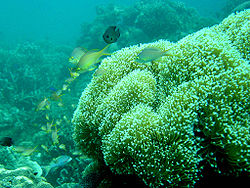
Since the 1970s, Moalboal has developed a tourism industry based on diving and beaches. Panagsama Beach, which was blown away by a typhoon in 1984, is where most resorts are established and White beach, which still has sand, in Barangay Savedra, which used to be a quieter beach that locals frequent, has only recently developed.
Tourists wanting to stay in Moalboal can easily take a taxi from Cebu International Airport. It should cost around 2500 Pesos, the ride takes around 2.5 hours. Other ways to get to Moalboal would be to take a taxi to the Liberando bus terminal or the South Bus station across the road. Librando and Ceres buses go to Moalboal, Fare is 89 Pesos. Make sure you are on a bus going via Barili, or you will end up in the South of Cebu.
In Moalboal most tourists stay at either Panagsama Beach (Basdiot) or White beach (Basdako). White Beach is known for its beautiful sandy beach and crystal clear water. There is plenty of accommodation near either beach, although Panagsama has the most bars and restaurants.
Entertainment is laid back and not for clubbers. You can have a beer for less than 45 Pesos in most bars. There is an outrageously loud Disco every Saturday at Pacitas, so be careful not to take a room close by if you want to sleep before sunrise.
Diving is the main activity, and it's very good, even according to Philippine standards. The house reefs are fine and Pescador island the best
The structure of the whole reef is ideal for snorkeling and freediving as well since the reef drop off is close to shore and shallow but goes down to 40 meters +.
Within a distance of 20 km from Moalboal you can explore numerous waterfalls, caves and canyons.
Barangays
Moalboal is administratively subdivided into 15 barangays.
- Agbalanga
- Bala
- Balabagon
- Basdiot
- Batadbatad
- Bugho
- Buguil
- Busay
- Lanao
- Poblacion East
- Poblacion West
- Saavedra
- Tomonoy
- Tuble
- Tunga
History
According to lore, Moalboal has a spring where many of the locals get their water. Once, a foreigner asked a woman with a cleft what the place was called. The woman thought he was asking her about the spring so she said that it was a bukal-bukal. However, because of her speech impediment, her words came out sounding like Moalboal and that was how the town got its name.
Another story is one of Laguno, a local warrior who was exiled from his hometown in Bohol. He and his family eventually came to the shores of Moalboal and settled there. Laguno had a yam-yam or oracion, a native prayer used to repel his enemies, and he used this to protect his home when moro invaders came. Legend goes that Laguno instructed his men to throw coconut husks into the water, then with the use of yam-yam, Laguno made it appear that the coconut husks were real men. Seeing that there were many warriors ready to defend the settlement, the moro invaders left. Laguno was revered by his people after that and when he died, it was said[who?] that his body was buried near a freshwater spring located, strangely enough, on the beach. His men placed a large tree trunk over his burial ground so as not to disturb him and it is said[who?] that even today, that trunk still exists. Whenever anyone tried to chop the trunk, it would bleed.
The street fronting the Municipal Hall of Moalboal is called Laguno Street in honor of the warrior. Laguno's burial ground is said[who?] to be located underneath the mangroves near the tulay. The spring still exists today.
External links
- Philippine Standard Geographic Code
- Moalboal Quick Info
- Moalboal Online Guide
- PADI Dive Center White Beach Moalboal
- PADI Dive Resort and Spa Moalboal- Learn to Dive Today
- CEBU SCUBA DIVERS NETWORK

Alcantara 
Tañon Strait 
Argao  Moalboal

Badian Component local government units of Cebu Municipalities Alcantara • Alcoy • Alegria • Aloguinsan • Argao • Asturias • Badian • Balamban • Bantayan • Barili • Boljoon • Borbon • Carmen • Catmon • Compostela • Consolacion • Cordova • Daanbantayan • Dalaguete • Dumanjug • Ginatilan • Liloan • Madridejos • Malabuyoc • Medellin • Minglanilla • Moalboal • Oslob • Pilar • Pinamungahan • Poro • Ronda • Samboan • San Fernando • San Francisco • San Remigio • Santa Fe • Santander • Sibonga • Sogod • Tabogon • Tabuelan • Tuburan • TudelaComponent cities Highly urbanized cities (Administratively independent from the province, but grouped under Cebu by the National Statistics Office)Categories:- Municipalities of Cebu
Wikimedia Foundation. 2010.


