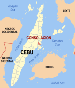
- Consolacion, Cebu
-
Consolacion — Municipality — Map of Cebu showing the location of Consolacion Location in the Philippines Coordinates: 10°22′36.72″N 123°57′24.85″E / 10.3768667°N 123.9569028°ECoordinates: 10°22′36.72″N 123°57′24.85″E / 10.3768667°N 123.9569028°E Country  Philippines
Region Central Visayas (Region VII) Province Cebu District 6th district of Cebu Founded Barangays 21 Government - Mayor Teresa "Nene" Pepito-Alegado Area - Total 142.20 km2 (54.9 sq mi) Population (2007) - Total 89,433 - Density 628.9/km2 (1,628.9/sq mi) Time zone PST (UTC+8) ZIP code Income class 1st class; partially urban Consolacion (colloquially ’Lacion) is a 1st[1] class municipality in the province of Cebu, Philippines. According to the 2007 census, it has a population of 89,433 people.
Consolacion is part of a metropolitan area informally called as Metro Cebu.
Barangays
Consolacion is administratively subdivided into 21 barangays.
- Cabangahan
- Cansaga
- Casili
- Danglag
- Garing
- Jugan
- Lamac
- Lanipga
- Nangka
- Panas
- Panoypoy
- Pitogo
- Poblacion Occidental
- Poblacion Oriental
- Polog
- Pulpogan
- Sacsac
- Tayud
- Tilhaong
- Tolotolo
- Tugbongan
External links
Notes
- ^ National Statistical Coordination Board, Municipality "ActiveStats".
Cities Municipalities Component local government units of Cebu Municipalities Alcantara • Alcoy • Alegria • Aloguinsan • Argao • Asturias • Badian • Balamban • Bantayan • Barili • Boljoon • Borbon • Carmen • Catmon • Compostela • Consolacion • Cordova • Daanbantayan • Dalaguete • Dumanjug • Ginatilan • Liloan • Madridejos • Malabuyoc • Medellin • Minglanilla • Moalboal • Oslob • Pilar • Pinamungahan • Poro • Ronda • Samboan • San Fernando • San Francisco • San Remigio • Santa Fe • Santander • Sibonga • Sogod • Tabogon • Tabuelan • Tuburan • TudelaComponent cities Highly urbanized cities (Administratively independent from the province, but grouped under Cebu by the National Statistics Office)Categories:- Municipalities of Cebu
Wikimedia Foundation. 2010.


