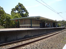
- Como railway station, Sydney
-
 Como
ComoEastern Suburbs & Illawarra Line Station code CMO Suburb Como Street(s) Como Parade Distance from Central Station 21.24 km Altitude (above sea level) ? m Types of stopping trains Suburban all stops Number of platforms 2 Number of tracks 2 Platform arrangement 1 Island Type of station Ground Ticket barriers No Transfers available None Disabled access 
No Station facilities Link Como railway station is located on the Illawara line of the CityRail network, in the southern Sydney suburb of Como. It consist of an island platform with access via a subway.
Contents
History
The first Como railway station was opened in December 1885 and made Como a popular weekend resort. When a new railway bridge over the Georges River was built adjacent to the original bridge in 1972, the original station was relocated about a kilometre southwards.
The original station platform[1] is still visible today near the southern end of the bridge. The station buildings have been demolished and a power sub-station was built in their place on the platform - most of which remains. There is no public access to the original platform but the subway tunnel under the rail line can still be used.
Platforms and services
The station is served by two trains per hour each way, with additional trains during weekday peak hours.
Platform Line Stopping Pattern Notes Eastern Suburbs & Illawarra Line all stations and limited stops services to Hurstville, Central and Bondi Junction via Central Eastern Suburbs & Illawarra Line all stations and limited stops services to Sutherland, Cronulla and Waterfall Accessibility
The station has stairs leading to a subway connected to the streets on either side, and thus does not have Easy Access for wheelchairs.
Transport links
No bus services stop at Como Station.
Gallery
-
New and old
Como Rail Bridges
Trackplan
Neighbouring stations
Preceding station CityRail Following station JannaliEastern Suburbs & Illawarra Line towards Bondi JunctionReferences
- ^ Como in the Sixties - Anecdotal Reflections Sim, C.J. Australian Railway Historical Society Bulletin, January, 1993 pp3-11
- The Book of Sydney Suburbs, Compiled by Frances Pollen, Angus & Robertson Publishers, 1990, Published in Australia ISBN 0-207-14495-8
Coordinates: 34°00′15″S 151°04′05″E / 34.0043°S 151.06802°E
Eastern Suburbs
& Illawarra Line- Bondi Junction
- Edgecliff
- Kings Cross
- Martin Place
- Town Hall
- Central
- Redfern
- Sydenham
- Tempe
- Wolli Creek
- Arncliffe
- Banksia
- Rockdale
- Kogarah
- Carlton
- Allawah
- Hurstville
- Penshurst
- Mortdale
- Oatley
- Como
- Jannali
- Sutherland
- Loftus
- Engadine
- Heathcote
- Waterfall
- Kirrawee
- Gymea
- Miranda
- Caringbah
- Woolooware
- Cronulla
(stations in italics are under planning or under construction)CityRail LinesSuburban - Eastern Suburbs & Illawarra
- Bankstown
- Inner West
- Airport & East Hills
- South
- Cumberland
- Western
- North Shore
- Carlingford
- Olympic Park
- Northern
Interurban and regional - South Coast
- Southern Highlands
- Blue Mountains
- Newcastle & Central Coast
- Hunter
Categories:- Railway stations in Sydney
- Railway stations opened in 1885
- Railway stations opened in 1972
Wikimedia Foundation. 2010.


