- New Cumberland, West Virginia
-
New Cumberland, West Virginia — City — Location of New Cumberland, West Virginia
Coordinates: 40°29′57″N 80°36′29″W / 40.49917°N 80.60806°WCoordinates: 40°29′57″N 80°36′29″W / 40.49917°N 80.60806°W Country United States State West Virginia County Hancock Area – Total 1.9 sq mi (4.9 km2) – Land 1.2 sq mi (3.2 km2) – Water 0.6 sq mi (1.7 km2) Elevation 722 ft (220 m) Population (2000) – Total 1,099 – Density 897.6/sq mi (346.6/km2) Time zone Eastern (EST) (UTC-5) – Summer (DST) EDT (UTC-4) ZIP code 26047 Area code(s) 304 FIPS code 54-58372[1] GNIS feature ID 1555205[2] New Cumberland is a city in Hancock County, West Virginia, USA, along the Ohio River. It is the county seat[3] and is part of the Weirton–Steubenville, WV-OH Metropolitan Statistical Area. The population was 1,099 as of the 2000 census.
Contents
History
In 1900, 2,198 people lived in New Cumberland; in 1910, 1,807; and in 2000, 1,099. Local industry in the past involved the manufacture of fire and paving brick, sewer pipe, glassware, foundry and machine-shop products, and tiling. There were also coal mines and mills for the pulverization of fire clay for use in ironworks.
In December 2010, an explosion and fire at the area's AL Solutions chemical plant, that manufactures chemicals related to aluminum, killed two workers and injured two others, one critically; no evacuations were necessary, as the surrounding area was judged safe. The plant had a similar incident earlier, in 2006, that killed one.
The First National Bank-Graham Building and Marshall House are listed on the National Register of Historic Places.[4]
Geography
New Cumberland is located at 40°29′57″N 80°36′29″W / 40.49917°N 80.60806°W (40.499146, -80.607960)[5].
According to the United States Census Bureau, the city has a total area of 1.9 square miles (4.8 km²), of which, 1.2 square miles (3.2 km²) of it is land and 0.6 square miles (1.7 km²) of it (34.76%) is water.
Demographics
As of the census[1] of 2000, there were 1,099 people, 513 households, and 286 families residing in the city. The population density was 897.6 people per square mile (347.8/km²). There were 568 housing units at an average density of 463.9 per square mile (179.8/km²). The racial makeup of the city was 99.27% White, 0.27% Asian, 0.09% from other races, and 0.36% from two or more races. Hispanic or Latino of any race were 1.09% of the population.
There were 513 households out of which 20.9% had children under the age of 18 living with them, 44.6% were married couples living together, 7.8% had a female householder with no husband present, and 44.1% were non-families. 39.2% of all households were made up of individuals and 22.4% had someone living alone who was 65 years of age or older. The average household size was 2.12 and the average family size was 2.85.
In the city the population was spread out with 19.1% under the age of 18, 6.1% from 18 to 24, 27.2% from 25 to 44, 26.6% from 45 to 64, and 21.0% who were 65 years of age or older. The median age was 43 years. For every 100 females there were 84.1 males. For every 100 females age 18 and over, there were 79.2 males.
The median income for a household in the city was $28,529, and the median income for a family was $37,589. Males had a median income of $30,625 versus $20,536 for females. The per capita income for the city was $18,109. About 6.2% of families and 9.5% of the population were below the poverty line, including 12.9% of those under age 18 and 7.5% of those age 65 or over.
See also
References
- ^ a b "American FactFinder". United States Census Bureau. http://factfinder.census.gov. Retrieved 2008-01-31.
- ^ "US Board on Geographic Names". United States Geological Survey. 2007-10-25. http://geonames.usgs.gov. Retrieved 2008-01-31.
- ^ "Find a County". National Association of Counties. http://www.naco.org/Counties/Pages/FindACounty.aspx. Retrieved 2011-06-07.
- ^ "National Register Information System". National Register of Historic Places. National Park Service. 2009-03-13. http://nrhp.focus.nps.gov/natreg/docs/All_Data.html.
- ^ "US Gazetteer files: 2010, 2000, and 1990". United States Census Bureau. 2011-02-12. http://www.census.gov/geo/www/gazetteer/gazette.html. Retrieved 2011-04-23.
Municipalities and communities of Hancock County, West Virginia Cities 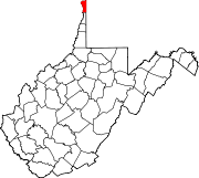
CDP Unincorporated
communitiesChestnut Hill | Congo | Fairhaven | Kings Creek | Lawrenceville | Lennyville | Moscow | New Manchester | Pleasant Valley | Sun Valley
Footnotes ‡This populated place also has portions in an adjacent county or counties
The Northern Panhandle of West Virginia Counties 
Communities Beech Bottom | Benwood | Bethlehem | Bethany | Cameron | Chester | Clearview | Follansbee | Glen Dale | McMechen | Moundsville | New Cumberland | New Vrindaban | Triadelphia | Valley Grove | Weirton | Wellsburg | West Liberty | Wheeling | Windsor Heights
Attractions Bethany College | Capitol Theatre | Chester Teapot | Grave Creek Mound | Mountaineer Casino, Racetrack and Resort | Oglebay Park | Palace of Gold | Tomlinson Run State Park | West Liberty University | West Virginia Independence Hall | West Virginia Northern Community College | West Virginia State Penitentiary | Wheeling Island | Wheeling Island Hotel-Casino-Racetrack | Wheeling Jesuit University | Wheeling Suspension Bridge | The Highlands Shopping, Dining & Entertainment Complex
Categories:- Cities in West Virginia
- Populated places in Hancock County, West Virginia
- County seats in West Virginia
- Weirton–Steubenville metropolitan area


Wikimedia Foundation. 2010.