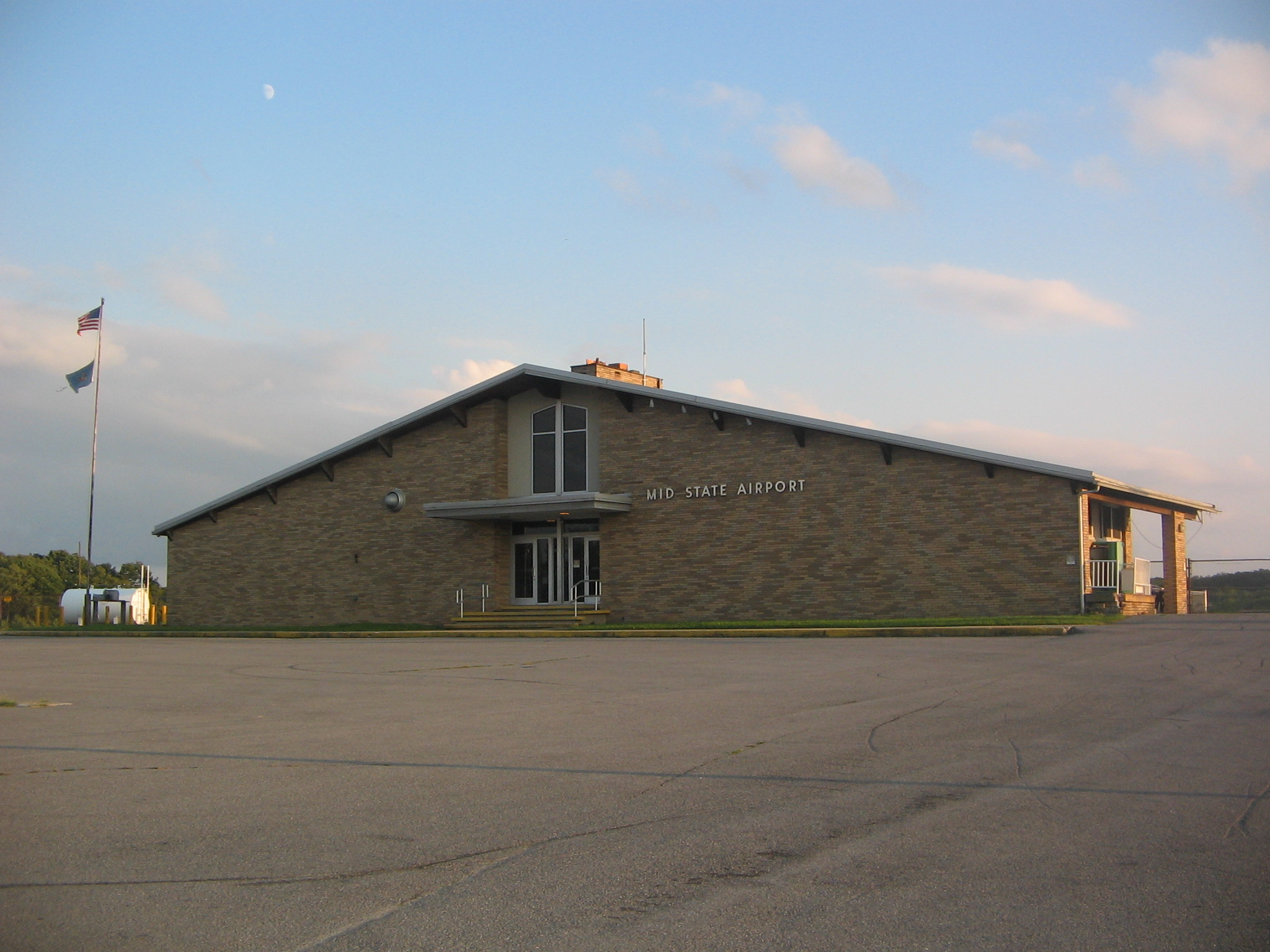
- Mid-State Regional Airport
-
Mid-State Regional Airport 
Main building of Mid-State Regional Airport IATA: PSB – ICAO: KPSB – FAA LID: PSB Summary Airport type Public Owner Mid-State Regional Airport Authority Serves Philipsburg, Pennsylvania Location Rush Township, Centre County, Pennsylvania Elevation AMSL 1,909 ft / 582UNIQ3f604fa3,612,112b-ref-00,000,000-QINU m Coordinates 40°53′00″N 78°05′14″W / 40.8833333°N 78.08722°W[1] Runways Direction Length Surface ft m 16/34[2] 5,711 1,741 Asphalt 6/24[2] 5,006 1,526 Asphalt Statistics (2007) Aircraft operations 2,550 Source: Federal Aviation Administration[3] Mid-State Regional Airport (IATA: PSB, ICAO: KPSB, FAA LID: PSB), also known as Mid-State Airport, is a small airport in Rush Township, Centre County in Pennsylvania in the United States. It is located between Black Moshannon State Park to the east and Moshannon State Forest in all other directions.
The airport is 8 nautical miles (15 km) east of the central business district of Philipsburg.[3] It is also 5 miles (8.0 km) from U.S. Route 322 and 10 miles (16 km) from Interstate 80.[4]
Contents
History
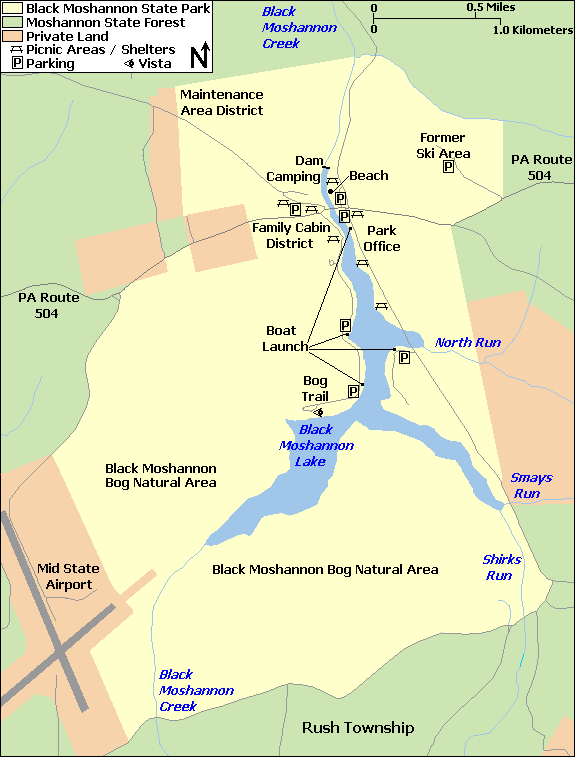
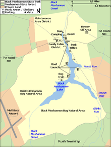 Location of Mid-State Regional Airport relative to Black Moshannon State Park
"Black Moshannon Airport" was built on land taken from Black Moshannon State Park and Moshannon State Forest just prior to the Second World War,[5] and was operational by 1942, hosting a Civil Air Patrol training exercise for nearly 300 planes on May 30, 1942.[6] It was re-named "Mid-State Airport" in 1962.[7]
The airport is 20 miles (32 km) from State College and Pennsylvania State University, and until the 1970s it was served by Allegheny Airlines (now US Airways). Over 75% of the airport's passengers were from the State College and Bellefonte area. After the new University Park Airport, owned by Penn State, opened in 1972, Allegheny Airlines gradually switched its service from Mid-State to University Park.[8] Today there is no scheduled airline service to Mid-State Regional Airport.[9]
As of 2008, the official name is "Mid-State Regional Airport" and it has been designated a Keystone Opportunity Zone (KOZ). The KOZ portion of the airport is on 484 acres (1.96 km2) to encourage business growth and is designated a KOZ through December 31, 2010.[4] However, there are limitations in state law that prohibit any further development on park or forest lands.[9]
Facilities and aircraft
Mid-State Airport covers an area of 500 acres (2.0 km2) which contains two asphalt paved runways: 16/34 measuring 5,711 x 100 ft (1,741 x 30 m) and 6/24 measuring 5,006 x 100 ft (1,526 x 30 m). For the 12-month period ending June 30, 2007, the airport had 2,550 aircraft operations: 98% general aviation and 2% military. Only two aircraft are based at the airport.[3]
There are five taxiways at the airport, designated A, B, C, D, and E. Runway 16/34 is connected to the airport ramp (or apron) by the 69-foot (21 m) wide taxiway A, as well as the 50-foot (15 m) wide taxiways D and E. Both D and E connect to the east side of the runway, with D leading to the large hangar and E to the smaller T-hangar. Runway 6/24 is connected to the airport ramp by the 96-foot (29 m) wide taxiway B, and the 50-foot (15 m) wide taxiway C at the 24-end of the runway. All of the taxiways are asphalt except for E, which is turf for the last 240 feet (73 m) before the runway.[2]
Other Users of the Airport
Based at Mid-State Regional Airport is the Civil Air Patrol Mid-State Composite Squadron 239. The Pennsylvania Bureau of Forestry bases a fire fighting aircraft at the airport during peak forest fire seasons.
The Central Pennsylvania Region Sports Car Club of America also hold autocross races at the airport.[10] Interestingly, the airport remains active during the races; when an aircraft wishes to land, the race will be temporarily suspended, the aircraft will land, and then racing will resume. This is made possible by the fact that due to the nature of autocross racing, only one car is on the course at any given time.
References
- ^ a b ""Mid-State Airport"". Geographic Names Information System. United States Geological Survey. August 30, 1990. http://geonames.usgs.gov/pls/gnispublic/f?p=gnispq:3:::NO::P3_FID:1194126. Retrieved 2008-04-04.
- ^ a b c "Mid-State Regional Airport: Details". Mid-State Regional Airport Authority. http://midstateairport.com/details.htm. Retrieved 2008-04-04.
- ^ a b c FAA Airport Master Record for PSB (Form 5010 PDF), effective 2007-12-20. Airport IQ 5010. Retrieved on April 18, 2008.
- ^ a b "SZ-1: Mid State Regional Airport". SEDA - Council of Governments. http://www.kozcentral.com/sz1-airport/default.htm. Retrieved 2008-04-03.
- ^ ""The ABC's of Centre County History"". Centre County Historical Society. http://www.centrecountyhistory.org/history/ABCsU.html. Retrieved 2008-01-31.
- ^ "290 Fliers in Rendezvous; Pennsylvania Civil Air Patrol Stages Training Operation". The New York Times. June 1, 1942. p. 28.
- ^ "Pennsylvania Aviation History". Pennsylvania Department of Transportation. http://www.dot.state.pa.us/Internet/Bureaus/pdBOA.nsf/History?OpenPage. Retrieved 2008-04-03. Note: this reference incorrectly gives the opening year as 1946
- ^ Michael Bezilla. ""Penn State: An Illustrated History - Equally Inaccessible from All Parts of the State"". Archived from the original on 2008-03-05. http://web.archive.org/web/20080305223804/http://www.libraries.psu.edu/speccolls/psua/psgeneralhistory/bezillapshistory/083sv176..htm. Retrieved 2008-04-07.
- ^ a b Gary Thornbloom. "Corridor O Interchange Poses Threat to Moshannon State Forest Lands". Pennsylvania Sierra Club. http://pennsylvania.sierraclub.org/moshannon/Newsletter%2000-09.pdf. Retrieved 2008-04-03. Note that this reference gives the founding date as 1940.
- ^ "Central Pennsylvania Region SCCA Locations". Sports Car Club of America. http://www.scca-cpr.org/cms/index.php/autocross/locations. Retrieved 2011-01-06.
External links
- Mid-State Regional Airport, official website
- FAA Terminal Procedures for PSB, effective 20 October 2011
- Resources for this airport:
- AirNav airport information for PSB
- ASN accident history for PSB
- FlightAware airport information and live flight tracker
- SkyVector aeronautical chart for PSB
Categories:- Airports in Pennsylvania
- Buildings and structures in Centre County, Pennsylvania
- Transportation in Centre County, Pennsylvania
Wikimedia Foundation. 2010.