- Jacqueline Cochran Regional Airport
-
Jacqueline Cochran Regional Airport 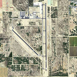
2006 USGS photo IATA: TRM – ICAO: KTRM Summary Airport type Public Operator Riverside County Location Thermal, California Elevation AMSL -115 ft / -34.7 m Coordinates 33°37′36″N 116°09′34.75″W / 33.62667°N 116.1596528°WCoordinates: 33°37′36″N 116°09′34.75″W / 33.62667°N 116.1596528°W Runways Direction Length Surface ft m 17/35 8,500 2,591 Asphalt 12/30 4,995 1,522 Asphalt 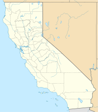
 Jacqueline Cochran RAPLocation of Jacqueline Cochran Regional Airport, California
Jacqueline Cochran Regional Airport (IATA: TRM, ICAO: KTRM) is a public airport located in Thermal, California, 20 miles (32 km) southeast of Palm Springs.
Built during World War II and used by both the US Army and US Navy, Jacqueline Cochran Regional Airport has had several name changes. As a civilian facility, it was called Thermal Airport from 1948 to 1998. To better reflect its regional function, the name was then changed to Desert Resorts Regional Airport. The most recent name change, to honor the pioneering aviator and Indio resident Jacqueline Cochran, took place in 2004.
The airport is one mile (1.6 km) west of the California State Route 86S expressway and six miles (10 km) south of Interstate 10 in the lower Coachella Valley of central Riverside County, an area known as the Desert Resorts Region. The communities of Palm Springs, Palm Desert, Indian Wells, La Quinta, Rancho Mirage, Cathedral City, Coachella, Indio and Thermal surround the airport.
The facility hosts an air show in late November, showcasing both full-scale aircraft and radio controlled models as flown by members of the Coachella Valley Radio Control Club. Due to that club's proximity to the facility, both the club and the airport work closely in mid-January to establish no-fly zones for the club's "Best In The West" national jet rally. A temporary model operational ceiling of 2000' (610m) is established during that time due to the size and speed of the models which participate.
Contents
Facilities
Jacqueline Cochran Regional Airport covers 1,850 acres (7.5 km2) and has two runways:
- Runway 17/35: 8,500 x 150 ft. (2,591 x 46 m), Surface: Asphalt
- Runway 12/30: 4,995 x 100 ft. (1,522 x 30 m), Surface: Asphalt
Airport Operational Statistics
Average of 208 operations per day.
Commercial Air Taxi GA Local GA Transient Military 0 1 75 130 2 55 aircraft based at airport.
Single Engine Multi Engine Jet Helicopter Glider/ Ultralight Military 36 8 3 3 5 0 History
The airport was established in 1942 at the beginning of World War II, being built as part of the Desert Training Center in the Mojave Desert of Southern California. The mission of the training center was to prepare United States Army ground forces in preparation for Operation Torch -- the invasion of North Africa. The center was commanded by General George Patton.
The airfield was known as Thermal Ground Support Base or Thermal Army Airfield. The 2,553-acre (10.33 km2) facility had two 5,000 ft (1,500 m) runways. Assigned to Fourth Air Force, between March 1943, and May 1944 the Army Air Forces assigned the 76th Reconnaissance Group along with several liaison and tactical reconnaissance squadrons to the airfield.
Located in the Coachella Valley 115 feet (35 m) below sea level, the place was named Thermal for a reason. Daily summer temperatures reached 120 °F (49 °C) in the shade soaring much higher on the concrete ramp. Conducting training here was not easy and summer flight operations took place from 0300 to 1300. In the heat of the day, the ground crews simply could not service the aircraft.
Phased down in 1944 after most Army units had deployed overseas to combat areas, Thermal had been inactive for six months when the United States Navy requested permission to occupy the base on December 2, 1944 with the stipulation that the Army could reoccupy with 30-days notice.
Initially known as Naval Air Bases Detachment Thermal, the base's facilities were in rather poor condition. During the first few months of the Navy's occupancy, the ACORNS and Seabees made extensive improvements. The airfield had a maximum capacity of 2,424 enlisted men and 264 officers. A hospital was located at the facility and had a maximum capacity of 119 patients, 68 nurses, 13 officers, and 16 enlisted men. There were approximately 254 buildings consisting of 237 military buildings built by DoD and 17 non-military buildings (present at the time of base acquisition). The airfield was improved with approximately 250 buildings, heating, lighting, telephone, sewer, water and power systems. NAB Thermal provided pilot refresher training. Aircraft strength reached 115 including the F6F, F4U, TBM, SB2C, and SBD. Station aircraft consisted of a J4F, an N2S, an NE, and a GB.
The Navy closed Thermal on November 1, 1945, returning the field to the Army two months later. The facility was inactivated and turned over to the Army Corps of Engineers on 1 January 1946.
The War Assets Administration turned the military airfield to civil control during 1947 and 1948. Approximately 39 acres (160,000 m2) were deeded on 20 June 1947 to United Date Growers of California. Approximately 40 acres (160,000 m2) were deeded on 2 September 1947 to Coachella Valley County Water District. On 21 December 1948 to the County of Riverside via Quitclaim Deed for use as a municipal airport.
Current era
Today, Thermal is a municipal airport serving general aviation.[2] [3] Currently, the site is of approximately 17 parcels totaling 2,549 acres (10.32 km2) of land owned by both public and private entities. Approximately 2,285 acres (9.25 km2) are owned by the County of Riverside for use as a municipal airport. The balance is used for agriculture and airpark development. Approximately 188 acres (0.76 km2) of the property transferred from the DoD to the County of Riverside were subsequently transferred to private parties.
See also
References
 This article incorporates public domain material from websites or documents of the Air Force Historical Research Agency.
- Maurer, Maurer (1983). Air Force Combat Units Of World War II. Maxwell AFB, Alabama: Office of Air Force History. ISBN 0892010924.
- Mauer, Mauer (1969), Combat Squadrons of the Air Force, World War II, Air Force Historical Studies Office, Maxwell AFB, Alabama. ISBN 0892010975
- Shaw, Frederick J. (2004), Locating Air Force Base Sites History’s Legacy, Air Force History and Museums Program, United States Air Force, Washington DC, 2004.
- ^ http://flightaware.com/resources/airport/KTRM/summary
- ^ "Historic California Posts, Thermal Army Air Field)". The California State Military Museum. http://www.militarymuseum.org/ThermalAAF.html. Retrieved 2008-04-19.
- ^ Thole, Lou (1999), Forgotten Fields of America : World War II Bases and Training, Then and Now - Vol. 2. Publisher: Pictorial Histories Pub, ISBN 1575100517
External links
- [1]
- [2]
- Riverside County Airport Land Use Commission
- Background Data: Jacqueline Cochran Regional Airport, 28-June-2005 (PDF 2846 kb)
- Jacqueline Cochran Regional Airport Airshow
- Resources for this airport:
- AirNav airport information for KTRM
- ASN accident history for TRM
- FlightAware airport information and live flight tracker
- NOAA/NWS latest weather observations
- SkyVector aeronautical chart for KTRM
- FAA current TRM delay information
Airfields Group Training Stations · Replacement Training Stations · Tactical Airfields
Units Commands IV Bomber Command · IV Fighter Command · IV Air Support CommandWings 21st Bombardment · Los Angeles Fighter · San Diego Fighter · San Francisco Fighter · Seattle FighterGroups Bombardment 12th Bombardment · 30th Bombardment · 41st Bombardment · 42d Bombardment · 47th Bombardment · 380th Bombardment · 385th Bombardment · 389th Bombardment · 392d Bombardment · 399th Bombardment · 449th Bombardment · 450th Bombardment · 451st Bombardment · 453rd Bombardment · 454th Bombardment · 455th Bombardment · 456th Bombardment · 461st Bombardment · 463d Bombardment · 465th Bombardment · 466th Bombardment · 470th Bombardment · 483rd Bombardment · 486th Bombardment · 491st Bombardment · 492d BombardmentFighter 1st Fighter · 14th Fighter · 20th Fighter · 35th Fighter · 51st Fighter · 55th Fighter · 78th Fighter · 81st Fighter · 82d Fighter · 328th Fighter · 329th Fighter · 339th Fighter · 354th Fighter · 360th Fighter · 363rd Fighter · 364th Fighter · 369th Fighter · 367th Fighter · 372d Fighter · 412th Fighter · 473d Fighter · 474th Fighter · 478th Fighter · 479th FighterReconnaissance 68th Reconnaissance · 69th ReconnaissanceTroop Carrier Categories:- Airports in Riverside County, California
- Coachella Valley
- World War II Desert Airfields
- USAAF Fourth Air Force Tactical Airfields
- Airfields of the United States Army Air Forces in California
- USAAF Fourth Air Force Group Training Stations
- Military in Riverside County, California
- 1942 establishments
- Colorado Desert


Wikimedia Foundation. 2010.