- Desert Training Center
-
Desert Training Center Part of United States Army Southern Californina/Western Arizona 
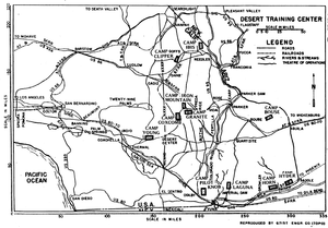
Map of Desert Training CenterType Army Training Area Coordinates 33°39′42″N 115°43′20″W / 33.66167°N 115.72222°W Built 1942 In use 1942-1944 Commanders Major General George S. Patton, Jr., April-August 1942. The Desert Training Center (DTC) was a World War II training facility established in the Mojave Desert; largely in Southern California and Western Arizona in 1942.
Its mission was to train United States Army and Army Air Corps units and personnel to live and fight in the desert, to test and develop suitable equipment, and to develop tactical doctrines, techniques and training methods.
It was a key training facility for units engaged in combat during the 1942-1943 North African campaign. It stretched from the outskirts of Pomona, California eastward to within 50 miles of Phoenix, Arizona, southward to the suburbs of Yuma, Arizona and northward into the southern tip of Nevada.
Contents
Overview
This simulated theater of operation was the largest military training ground in the history of military maneuvers. A site near Shavers Summit (now known as Chiriaco Summit) between Indio and Desert Center, was selected as the headquarters of the DTC. The site, called Camp Young, was the world's largest Army post.
Major General George S. Patton Jr. came to Camp Young as the first Commanding General of the DTC. As a native of southern California Patton knew the area well from his youth and from having participated in Army maneuvers in the Mojave Desert in the 1930s. His first orders were to select other areas within the desert that would be suitable for the large-scale maneuvers necessary to prepare American soldiers for combat against the German Afrika Korps in the North African desert.
Patton and his advanced team designated various locations within the area where tent camps would be built. The camps were situated so that each unit could train individually without interfering with the other. Airfields, hospitals, supply depots and sites for other support services were selected as was a corps maneuvering area. The plan was that each division and or major unit would train in its own area, and near the end of its training period would participate in a corps (two divisions or more) exercise in the corps maneuvering area at Palen Pass. Upon completion of the corps exercise, the trained units would leave the DTC, and new units would arrive to begin their training and the process repeated.
By March 1943, the North African campaign was in its final stages and the primary mission of the DTC had changed. By the middle of 1943, the troops who originally came for desert training maneuvers, were now deployed worldwide. Therefore, to reflect that change in mission, the name of the Center was changed to the California-Arizona Maneuver Area (C-AMA or CAMA). The CAMA was to serve as a Theater of Operations to train combat troops, service units and staffs under conditions similar to those which might be encountered overseas. The CAMA was enlarged to include both a Communications Zone and Combat Zone, approximately 350 miles wide and 250 miles long.
Most of the sites can be visited, but some are difficult to reach. In most cases the only things that remain at the camp sites are streets, sidewalks, building foundations, patterns of hand-laid rocks for various purposes and trash dumps. Monuments have been erected at some of the camp sites and there are areas within CAMA that are fenced off with danger signs warning of unexploded ordnance.
The General George S. Patton Memorial Museum is located near the former entrance of Camp Young.
Lineage
- Activated 1 April 1942
-
- Radio message Headquarters, War Department, Washington, D.C.
- Re-designated: California-Arizona Maneuver Area, 20 October 1943
- War Department Memo W210-27-43, dated 18 October 1943
- Closed 1 July 1944
- War Department Circular 207, 20 June 1944
Army Divisional Camps supporting the DTC/CAMA
- Camp Bouse (secret camp)
- Camp Coxcomb
- Camp Desert Center
- Camp Essex
- Camp Granite
- Camp Hyder
- Camp Ibis
- Camp Iron Mountain
- Camp Young
Army Airfields supporting the DTC/CAMA
- Major airfields
- Minor airfields
- Camp Coxcomb Army Field (Freda, CA; Abandoned) 33°55′12″N 115°14′24″W / 33.92°N 115.24°W
- Camp Essex Army Field (Essex, CA; Abandoned) 34°46′19″N 115°13′15″W / 34.77194°N 115.22083°W
- Camp Goffs Army Field (Goffs, CA; Abandoned) 34°56′12″N 115°04′04″W / 34.93667°N 115.06778°W
- Camp Ibis Army Field (Ibis, CA; Abandoned) 34°58′12″N 114°50′23″W / 34.97°N 114.83972°W
- Camp Iron Mountain Army Field (Desert Center, CA; Abandoned) 34°05′58″N 115°06′29″W / 34.09944°N 115.10806°W
References
- Bureau of Land Management information borchure, Desert Training Center
- Historic California Posts California/Arizona Maneuver Area (Desert Training Center)
- The Army Almanac: A Book of Facts Concerning the Army of the United States, U.S. Government Printing Office, 1950 reproduced at CMH.
- USACE FUDS ASR's (U.S. Army Corps of Engineers-formerly used defense sites-Archive Search Report)
Categories:- Former United States Army training facilities
- Military facilities in Arizona
- Military facilities in California
- American Theater of World War II
Wikimedia Foundation. 2010.
