- North Texas Regional Airport
-
For usage of airport before 1971, see Perrin Air Force Base.
North Texas Regional Airport
(Grayson County Airport)
Perrin Field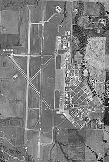
USGS aerial photo, 22 Jan 1999 IATA: PNX – ICAO: KGYI – FAA LID: GYI Summary Airport type Public Owner Grayson County, Texas Serves Sherman / Denison Elevation AMSL 749 ft / 228 m Coordinates 33°42′51″N 096°40′25″W / 33.71417°N 96.67361°W Runways Direction Length Surface ft m 13/31 2,277 694 Asphalt 17L/35R 9,000 2,743 Asphalt/Concrete Statistics (2007) Aircraft operations 53,300 Based aircraft 169 Source: FAA[1] and airport website[2] North Texas Regional Airport / Perrin Field[2] (IATA: PNX, ICAO: KGYI, FAA LID: GYI) is a county-owned public use airport in Grayson County, Texas, United States. It is located between the cities of Sherman and Denison.[1] Formerly known as Grayson County Airport, the airport was renamed in November 2007.[2] It is used entirely for general aviation purposes. Several of the buildings are occupied by businesses, Grayson County government agencies, as well as Grayson County College.
Although most U.S. airports use the same three-letter location identifier for the FAA and IATA, this airport is assigned GYI by the FAA and PNX by the IATA[3] (which assigned GYI to an airport in Gisenyi, Rwanda[4]).
As a general aviation reliever airport, unconfirmed reports suggest that the airport might potentially (in the distant future) serve as a third airport for the Dallas/Fort Worth Metroplex to handle travelers from its growing northern suburbs. If this occurs, commercial traffic would be focused on regional jet airline operations. A planned extension of State Highway 289 would pass the airport on the west side.
Contents
History
For usage of airport before 1971, see Perrin Air Force Base.The airport is located on the site of the former Perrin Air Force Base, which was built in 1941 and closed in 1971.[5] Since the closure, a small group of local Sherman and Denison citizens have held the memory of Perrin together, hosting nine Perrin Field reunions since the early 1980s. The Perrin AFB Research Foundation was established in 1998. Today, in addition to serving as a general aviation airport, several businesses, as well as a juvenile detention center/boot-camp and adult probation center are built upon former barracks and nearby areas. There is a small museum dedicated to the former Perrin Air Force Base at the airport and Grayson County College uses several of the buildings for its course offerings. The college also operates the former base golf course.
After seeing the fighters take off from here, a young Chesley Sullenberger became interested in flying.[6][7]
Facilities and aircraft
The airport covers an area of 1,410 acres (570 ha) at an elevation of 749 feet (228 m) above mean sea level. It has two runways: 17L/35R is 9,000 by 150 feet (2,743 x 46 m) with an asphalt/concrete surface; 13/31 is 2,277 by 60 feet (694 x 18 m) with an asphalt surface.[1]
It originally had three runways, but one 8,000'(2,438m) runway is closed and is used solely as a taxiway. The airport has an operational Category I instrument landing system (ILS) to Runway 17L. The former USAF control tower resumed operations in mid-2008.
For the 12-month period ending April 30, 2007, the airport had 53,300 aircraft operations, an average of 146 per day: 98% general aviation, 2% military and <1% air taxi. At that time there were 169 aircraft based at this airport: 73% single-engine, 11% multi-engine, 11% jet, 4% helicopter and 1% ultralight.[1]
References
- ^ a b c d FAA Airport Master Record for GYI (Form 5010 PDF), effective 2009-07-02.
- ^ a b c North Texas Regional Airport, official site
- ^ Great Circle Mapper: PNX / KGYI - Sherman/Denison, Texas - Grayson County Airport
- ^ Aviation Safety Network: GYI / HRYG - Gisenyi Airport, Rwanda
- ^ North Texas Regional Airport: History
- ^ Rivera, Ray (January 16, 2009). "A Pilot Becomes a Hero Years in the Making". The New York Times. http://www.nytimes.com/2009/01/17/nyregion/17pilot.html?pagewanted=2&_r=1&hp
- ^ Kaufmann, Carol (January 16, 2009). "Hudson River Hero". AARP Today. American Association of Retired Persons. http://bulletin.aarp.org/yourworld/gettingaround/articles/hudson_river_hero.html. Retrieved March 16, 2009.
External links
- Perrin Field Historical Society and Museum
- Sherman/Denison, Grayson County (GYI) at Texas DOT Airport Directory
- FAA Terminal Procedures for Grayson County (GYI), effective 20 October 2011
- Resources for this airport:
- AirNav airport information for KGYI
- ASN accident history for PNX
- FlightAware airport information and live flight tracker
- NOAA/NWS latest weather observations
- SkyVector aeronautical chart, Terminal Procedures for KGYI
Categories:- Airports in Texas
- Buildings and structures in Grayson County, Texas
- Transportation in Grayson County, Texas

Wikimedia Foundation. 2010.