- Worcester Regional Airport
-
Worcester Regional Airport 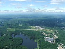
IATA: ORH – ICAO: KORH – FAA LID: ORH Summary Airport type Public Owner Massachusetts Port Authority (Massport) Operator Massachusetts Port Authority (Massport) Location Worcester, Massachusetts Elevation AMSL 1,009 ft / 308 m Coordinates 42°16′02″N 071°52′33″W / 42.26722°N 71.87583°W Maps FAA airport diagram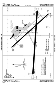 Location within Massachusetts
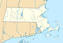
 ORH
ORHRunways Direction Length Surface ft m 11/29 7,000 2,134 Asphalt/grooved 15/33 5,000 1,524 Asphalt/grooved Statistics (2009) Aircraft operations 55,216 Based aircraft 65 Source: Federal Aviation Administration[1] Worcester Regional Airport (IATA: ORH, ICAO: KORH, FAA LID: ORH) is a public airport located three miles (5 km) west of the central business district of Worcester, a city in Worcester County, Massachusetts, United States. The main airport property lies within Worcester and Leicester, with substantial supporting facilities in Paxton. Once owned by the City of Worcester, the airport is currently owned and operated by the Massachusetts Port Authority (Massport) since June 2010.[2]
Contents
History
Worcester's entry into the world of aviation began in 1925, when city officials commissioned a study to examine suitable sites for the city's first airport. On the list of probable sites was the land owned by a wealthy local citizen, Whitin Whitall. In 1927, Whitall, independently of the city commission, set up an airport on his land in North Grafton, 500 feet (150 m) above sea level. This two-runway airport opened for leisure travel on 12 October 1927.[3]
As air travel became more popular throughout the country and Central Massachusetts, the question of airport expansion became the subject of a second study commissioned by the Worcester city government. The Grafton airport was deemed too small to accommodate the air travel needs of the region. The location of the present airport, Tatnuck Hill, an area that straddles the borders of Worcester, Leicester, and Paxton, was high on the commission's list. One problem noted by the commission and several prominent citizens was the weather: at 1,000-foot (300 m) above sea level, the Tatnuck site was often surrounded by fog. Despite this problem, the city eventually chose Tatnuck as the new site, and construction began in 1944. The airport was ceremoniously opened on 4 May 1946, and started regular passenger service one week later on 10 May 1946.
The Grafton airport remained in operation until 1951, when the owners, due to the dwindling traffic, decided to dismantle the airport. The land was redeveloped as a residential neighbourhood.[4] Leicester Airport, a small private airfield also built during the first half-century of aviation, was active until the 1970s. It still sits, now mostly overgrown in the shadow of Worcester Regional.[5]
Millions of dollars were spent replacing the old terminal, which hosted a half-dozen airlines before its demolition. In the mid 1980s and early 1990s, major carriers, such as Piedmont, Continental, and USAir all flew mainline jets into Worcester. In addition, smaller carriers, like New York Air and Presidential Airways also had jet service. The small terminal had two ground level jetways built to accommodate the growth. But one by one, those carriers left. A succession of second-tier air carriers have come and gone over the last decade.
Allegiant Air began service to Orlando Sanford International Airport (SFB) on 22 December 2005, using Boeing MD-80 type aircraft. The airline expanded to 4 flights per week in March 2006. Allegiant announced on 22 August 2006, that they would cut ties with the airport, citing high fuel costs and passenger loads in the 80% range as the reason for departure. The departure came as a huge surprise to the city as service was reported to be going great throughout Allegiant's entire tenure at the airport.[6]
On 4 September 2008, Direct Air announced they would begin service to Worcester beginning in November 2008, with flights from Orlando, FL and Fort Myers/Punta Gorda, FL. The flights were operated by Virgin America using Airbus A320 aircraft, until Direct Air returned the aircrafts in June 2009 to suffice Virgin's rapidly expanding domestic routes. Flights used to be operated by a Falcon Air Express MD-83. In March 2009, Direct Air added additional flights to Myrtle Beach, SC. In July 2010, Direct Air expanded their Worcester service further to West Palm Beach, and is expected to announce further destinations in the near future.
The airport commission had suggested Worcester/Metrowest Boston Regional Airport as a new name for the airport in 2006.[7] However this topic has not been pursued further.
In late 2009, the airport's terminal was used to film scenes from the movie Knight and Day, starring Tom Cruise and Cameron Diaz.
Massport
The airport had been under an operating agreement with Massport, the Massachusetts Port Authority for several years. Under the agreement, the city and Massport paid the operating deficit together.
- 1 July 2004 – 30 June 2005 – MassPort pays 100% of operating deficit not including debt service
- 1 July 2005 – 30 June 2006 – MassPort pays 85% of operating deficit not including debt service
- 1 July 2006 – 30 June 2007 – MassPort pays 68% of operating deficit not including debt service[8]
By law, Worcester had to transfer ownership of the airport to Massport sometime in 2009 or 2010.[9] As of 1 July 2010, Massport is the owner and operator of the airport.
Statistics
For 12-month period ending 31 May 2009, the airport had 55,216 aircraft operations, an average of 151 per day: 94% general aviation, 4% air taxi, <1% scheduled commercial and <1% military. There are 65 aircraft based at this airport: 89% single engine, 9% multi-engine and 2% jet aircraft.[1]
At its peaks in 1989, Worcester Airport served about 354,000 passengers. In 2009, the airport served fewer than 50,000 passengers.[10]
Facilities and infrastructure
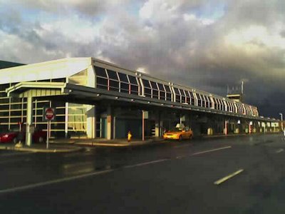
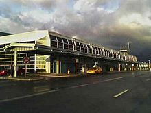 Worcester Airport terminal curbfront
Worcester Regional Airport covers an area of 1,000 acres (4 km²) which contains two runways: 11/29 measuring 7,000 x 150 ft (2,134 x 46 m) and 15/33 measuring 5,000 x 100 ft (1,524 x 30 m).[1] ILS is available for runways 11 and 29, with runway 11 being certified for CAT I Instrument Landing operations.[11] EMAS pads are located at the starting thresholds of runways 11 and 29.[12]
The airport passenger terminal has four jetway gates (two of which are operational) and two ramp level gates for regional carriers. The terminal also houses two baggage carousels and a TSA installed passenger and baggage screening system.[13]
WBZ-TV operates a Doppler weather radar station at the airport.
Allen Aviation LLC, The Worcester Regional Flight Academy, began operations as a Part 61 flight school out of the Swissport FBO on 1 May 2010. While the primary focus is upon private pilot, instrument, commercial training and specialized youth programs, the Academy plans to expand its training programs as well as grow its current fleet of aircraft to include multi-engine and ATP training in the future. These aircraft include a Cessna 172P Skyhawk, Piper Cherokee PA-28-140 and a Piper Warrior PA-28-151, each equipped with a Garmin GPS 430W.[14] The Academy also maintains an FAA-certified ELITE PI-135 Flight Simulator with Garmin GPS 430W wherein 2.5 hours of training may be counted toward the Private Pilot certificate, 10 hours toward the Instrument Rating, and also allows Instrument Pilots the ability to maintain their Required Flight Experience (RFE) currency.
Airlines and destinations
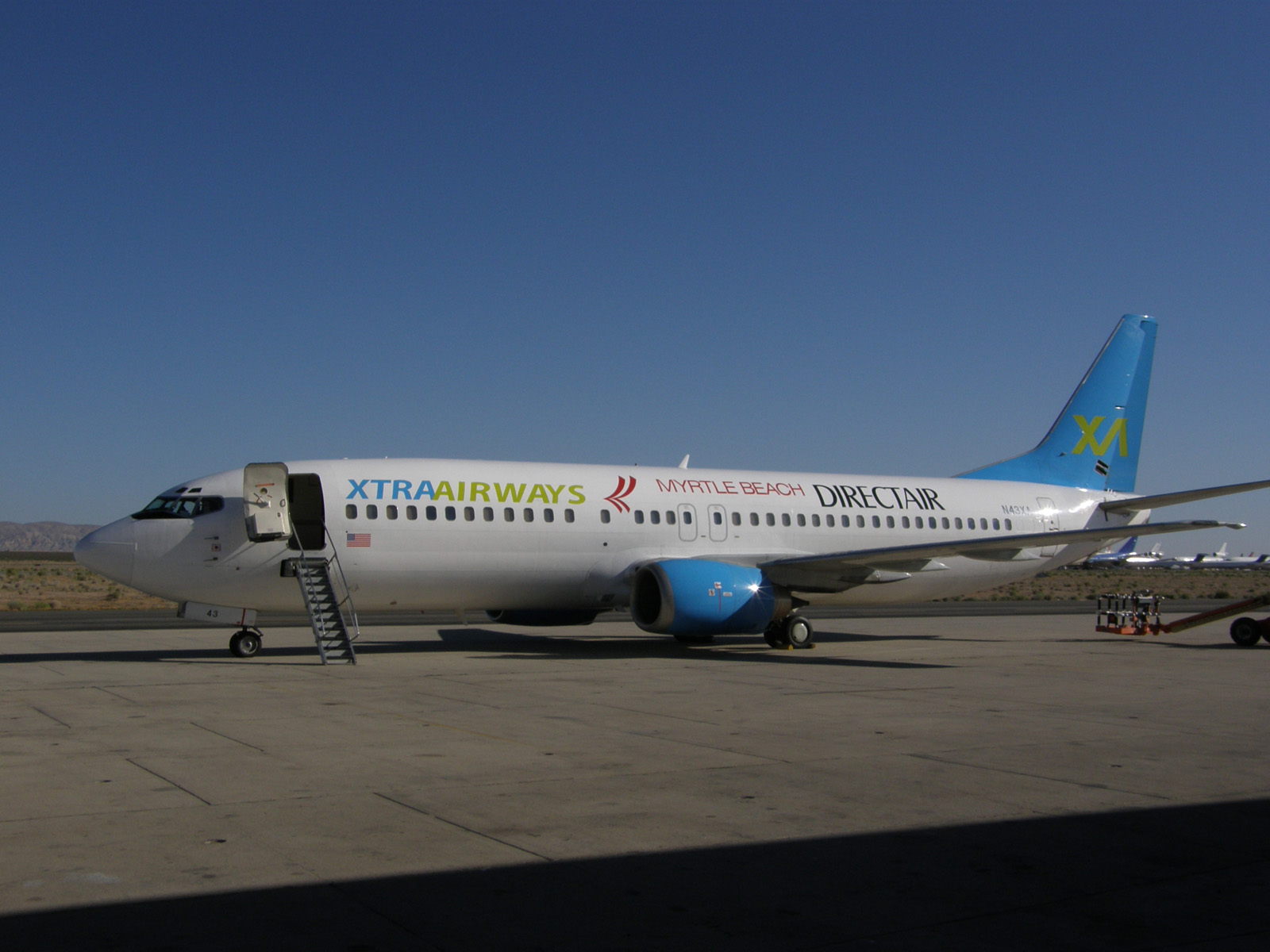
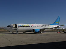 Direct Air (operated by Xtra Airways) airplane
Direct Air flights are operated by Xtra Airways, Sky King, Inc. and Vision Airlines depending on the season. During the summer the flight to Punta Gorda is operated through Sanford with one flight in both directions. During the winter, both Punta Gorda and Sanford have their own roundtrip from Worcester. Flights generally operate on Thursdays, Saturdays, and Sundays.
On April 7, 2011, Direct Air announced new service from Worcester to Nassau, Bahamas and San Juan, Puerto Rico commencing November 17, 2011. However, due to inability to acquire an aircraft to operate the service, San Juan service has been delayed until May 2012 and Nassau flights have been delayed indefinitely.[15]
Due to wet-leasing their only aircraft, occasionally Direct Air will have loan a plane from other airlines not under contract to meet the demand of that day. Such visitors to Worcester have included a North American Airlines Boeing 757 and a USA 3000 Airbus A320.
A monthly charter to Atlantic City is run usually on a Sunday by a Sky King, Inc. 737. Although they have died down in the past year, the flights are still available and can be booked through the airport's website. Even though the flights are also run by Sky King, these flights have no association with Direct Air.
In September 2011, numerous sources reported that JetBlue Airlines was asked by Massport to begin service to Worcester. Sharon Jones, a Spokesperson for Jetblue stated "JetBlue is constantly evaluating many airports and Worcester in one of them." However, the airport would need to update its navigational systems to allow for operations in lower weather minimums.[16]
Airlines Destinations Direct Air operated by various carriers Fort Myers/Punta Gorda, Myrtle Beach, Orlando-Sanford, San Juan [begins May 3], West Palm Beach Ground transportation
Three rental car agencies are located in the terminal building at Worcester Regional Airport. Avis, Hertz, and Thrifty all have concession stands across from the baggage claim.
The Worcester Regional Transit Authority (WRTA)'s route #19 bus connects Union Station, a regional MBTA Commuter Rail, Amtrak, and bus transportation hub in the Downtown Worcester district, with the airport. Union Station is the western terminus of the Massachusetts Bay Transportation Authority's Framingham/Worcester commuter rail line, with eastbound service to Back Bay and South Station in Boston. Additionally, service via Amtrak's Lake Shore Limited Boston section to/from Albany, New York, with connections to Chicago (formerly also the Regional's Inland Route) stops at this location, as does intercity (Peter Pan Bus Lines), (Greyhound Bus Lines), and other local WRTA bus services at Union Station.
The airport presently lacks a direct connection to an Interstate Highway. However, a number of Interstate routes such as: I-290, I-90, I-190, I-395, I-495, and routes: MA-9, MA-122, and MA-146 provide access through smaller access roads.[17]
References
- ^ a b c FAA Airport Master Record for ORH (Form 5010 PDF). Retrieved 16 October 2010.
- ^ Massport (22 June 2010) "Massport, Worcester Airport Deal Completed" Massachusetts Department of Transportation (MASSDOT) http://transportation.blog.state.ma.us/blog/2010/06/massport-worcester-airport-deal-completed.html. Retrieved 26 June 2010
- ^ Southwick, Albert B. (1994). Once-Told Tales of Worcester County. Worcester: Databooks.
- ^ Freeman, Paul (13 March 2010). "Abandoned Airfields: Grafton, MA". Abandoned & Little-Known Airfields: Western Massachusetts. http://www.airfields-freeman.com/MA/Airfields_MA_W.htm#grafton. Retrieved 16 October 2010.
- ^ Freeman, Paul (13 March 2010). "Abandoned Airfields: Leicester, MA". Abandoned & Little-Known Airfields: Western Massachusetts. http://www.airfields-freeman.com/MA/Airfields_MA_W.htm#leicester. Retrieved 16 October 2010.
- ^ "Allegiant Air will leave Worcester". Worcester Telegram and Gazette. 23 August 2006. http://nl.newsbank.com/nl-search/we/Archives?p_product=WO&p_theme=wo&p_action=search&p_maxdocs=200&p_topdoc=1&p_text_direct-0=113B70D44AB32A90&p_field_direct-0=document_id&p_perpage=10&p_sort=YMD_date:D&s_trackval=GooglePM. Retrieved 16 October 2010.
- ^ "New name flying toward Worcester Airport". Worcester Telegram & Gazette. 11 May 2006. http://nl.newsbank.com/nl-search/we/Archives?p_product=WO&p_theme=wo&p_action=search&p_maxdocs=200&p_topdoc=1&p_text_direct-0=111A26ED2AE10530&p_field_direct-0=document_id&p_perpage=10&p_sort=YMD_date:D&s_trackval=GooglePM. Retrieved 16 October 2010.
- ^ "Comprehensive Annual Financial Report" (PDF). Massport. 30 June 2005. http://www.massport.com/massport/Documents/Investor%20Relations%20Documents/Comprehensive%20Annual%20Financial%20Report%20-%20Year%20Ended%20June%2030,%202005.pdf. Retrieved 16 October 2010.
- ^ "Chapter 25 of the Acts of 2009, Section 148". Massachusetts General Court. 25 June 2009. http://www.mass.gov/legis/laws/seslaw09/sl090025.htm. Retrieved 16 October 2010.
- ^ Chase, Katie Johnston (1 June 2010). "Ailing airport seeking its niche". The Boston Globe. http://www.boston.com/business/articles/2010/06/01/ailing_worcester_airport_seeking_its_niche/. Retrieved 16 October 2010.
- ^ "KORH: Worcester Regional Airport". FAA Information. Airnav.com. 23 September 2010. http://www.airnav.com/airport/KORH. Retrieved 16 October 2010.
- ^ FAA Airport Diagram.
- ^ "Worcester Regional Airport". City of Worcester Economic, Neighborhood & Workplace Development. 2010. http://www.worcesterma.gov/development/airport. Retrieved 16 October 2010.
- ^ "About Us". Allen Aviation LLC. 2010. http://www.worcesterregionalflightacademy.com/aboutus.html. Retrieved 16 October 2010.
- ^ Nicodemus, Aaron. Direct Air puts Bahamas, San Juan flights on hold, Telegram & Gazette, November 10, 2011, Retrieved 2011-11-11
- ^ "http://www.wbjournal.com/news49906.html, Worcester Business Journal, Sep 23,
- ^ "To and From Worcester Regional Airport". MassPort. 2010. http://www.massport.com/worce/worce_direct.html. Retrieved 16 October 2010.
External links
- Worcester Regional Airport (City of Worcester web site)
- Worcester Regional Airport (Massport web site)
- Worcester Regional Flight Academy
- FlyORH.com
- FAA Airport Diagram for Worcester Regional Airport (PDF), effective 20 October 2011
- Resources for this airport:
- AirNav airport information for KORH
- ASN accident history for ORH
- FlightAware airport information and live flight tracker
- NOAA/NWS latest weather observations
- SkyVector aeronautical chart for KORH
- FAA current ORH delay information
Categories:- Airports in Massachusetts
- Massachusetts Port Authority
- Transportation in Worcester, Massachusetts
- Buildings and structures in Worcester, Massachusetts
- Leicester, Massachusetts


Wikimedia Foundation. 2010.