- Charlotte County Airport
-
Charlotte County Airport 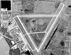
USGS aerial photo as of 6 January 1999 IATA: PGD – ICAO: KPGD – FAA LID: PGD Summary Airport type Public Owner Charlotte County Airport Authority (Charlotte County, Florida) Serves Charlotte County, Florida Location Charlotte County, near Punta Gorda, Florida Elevation AMSL 26 ft / 8 m Coordinates 26°55′11″N 081°59′26″W / 26.91972°N 81.99056°W Website Runways Direction Length Surface ft m 4/22 6,695 2,041 Asphalt 15/33 5,688 1,734 Asphalt 9/27 5,044 1,537 Asphalt 9/27 available distance 2,630 802 Asphalt Statistics (2006) Aircraft operations 74,743 Based aircraft 295 Sources: FAA,[1] airport website[2] Updated runway distance Airnav.com,[3], Allegiant Air [4], Direct Air [5], Vision Airlines [6]
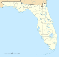
 Charlotte County AirportLocation of Charlotte County Airport, Florida
Charlotte County Airport (IATA: PGD, ICAO: KPGD, FAA LID: PGD) is a public airport located 3 mi (5 km) southeast of the central business district of Punta Gorda, in Charlotte County, Florida, United States. It is owned by the Charlotte County Airport Authority.[1]
Charlotte County Airport has mainly been used for deplanements of single engine and small jet aircraft, but has recently seen a heavy increase in schedule commercial airline service. The airport is home to the Florida International Air Show,[7] an annual event which has featured various military demonstration teams, such as the United States Navy's Flight Demonstration Squadron, the "Blue Angels"; the "U.S. Air Force Thunderbirds"; and the United States Army's "Sky Soldiers" (173rd Airborne Brigade Combat Team) Cobra helicopter team.
Charlotte County Airport has serviced several commercial airline tenants throughout its existence, but saw no major commercial operations after the early 1980s in the aftermath of the Airline Deregulation Act of 1978. Commercial operations again commenced at PGD in 2007 when both Skybus Airlines and DayJet began providing flights to and from the airport. Service by these airlines, however, proved to be temporary at best with Skybus and Dayjet ceasing operations on April 5th, 2008 and September 19th, 2008 (respectively).
Commercial service out of PGD once again resumed on November 22nd, 2008 when low-cost carrier Direct Air began twice weekly service to 10 destinations across the eastern US. On December 2, 2008 low-cost airline Allegiant Air also announced it would open a new focus city at PGD, and began service to Greenville, SC and Knoxville, TN on March 5, 2009. A third airline, Vision Airlines also commenced weekly flights to Northwest Florida Regional Airport in Destin on March 25, 2011. Vision has since allowed for ticketed flights from Punta Gorda to Atlanta, Savannah, and Asheville via the airline's Destin/Fort Walton Beach hub.
Contents
Airlines and destinations
Airlines Destinations Allegiant Air Greensboro, Greenville/Spartanburg, Knoxville, Lexington Direct Air operated by various carriers Allentown, Chicago/Rockford, Kalamazoo, Niagara Falls, Myrtle Beach, Plattsburgh, Springfield (IL), Toledo, Worcester Direct Air operated by Vision Airlines St Petersburg Vision Airlines Seasonal: Champaign [begins December 19], Louisville [Begins December 19] Facilities and aircraft
Charlotte County Airport covers an area of 1,934 acres (783 ha) which contains three asphalt paved runways: 4/22 measuring 6,695 × 150 ft (2,041 × 46 m), 15/33 measuring 5,688 × 150 ft (1,734 × 46 m), and 9/27 measuring 2,630 × 60 ft (802 × 18 m).[1]
For the 12-month period ending December 31, 2006, the airport had 74,743 aircraft operations, an average of 204 per day: 97% general aviation, 3% air taxi and <1% military. There are 295 aircraft based at this airport: 82% single-engine, 11% multi-engine, 2% jet, 2% helicopter and 2% ultralight.[1]
World War II
In 1941, just prior to the beginning of World War II, the US Army Corps of Engineers planned and constructed an airfield on the current airport property as a combat pilot training base for the US Army Air Forces' Third Air Force, naming the facility Punta Gorda Army Airfield. By 1944, the base reached its peak in housing 1,000 personnel, including two squadrons of student pilots.
The base initially had forty Curtis P-40 Warhawk aircraft assigned, later transitioning to the North American P-51 Mustang aircraft. Pursuit (i.e., "fighter") aircraft training in the P-40 and P-51 represented advanced phase training for Army Air Forces fighter pilots prior to their being deployed with USAAF operational units in the European and Pacific Theaters of Operation. Punta Gorda Army Airfield was a subordinate command of 3rd Air Force, 3rd Fighter Command at Drew Field (now Tampa International Airport), and also had C-45 Expeditor and C-47 Skytrain transport aircraft assigned for support purposes.
All base officers and some senior non-commissioned officers lived in Punta Gorda, while all student officers and most enlisted men lived in tent structures on the base. Semi-permanent buildings included an operations headquarters, classrooms, supply building, fire station, dispensary, chapel and the control tower. The base also had nose dock hangars, where just the nose of the aircraft was under shelter for repairs.
Following the war, the US Government issued a Deed of Release transferring all of the fixtures and improvements situated on the property to the local jursidiction of Charlotte County.[citation needed]
See also
References
 This article incorporates public domain material from websites or documents of the Air Force Historical Research Agency.
- ^ a b c d FAA Airport Master Record for PGD (Form 5010 PDF), effective 2007-10-25
- ^ Charlotte County Airport (official site)
- ^ Airnav.com
- ^ allegiantair.com
- ^ visitdirectair.com
- ^ visionairlines.com
- ^ Florida International Air Show
External links
- Charlotte County Airport Brochure PDF (873 KiB)
- FAA Terminal Procedures for PGD, effective 20 October 2011
- Resources for this airport:
- AirNav airport information for KPGD
- ASN accident history for PGD
- FlightAware airport information and live flight tracker
- NOAA/NWS latest weather observations
- SkyVector aeronautical chart, Terminal Procedures for KPGD
 USAAF Third Air Force in World War II
Airfields Group Training Stations · Replacement Training Stations · Tactical Airfields
Units Commands II Air Support Command · III Air Support Command · III Bomber Command · III Fighter Command · III Reconnaissance Command · III Tactical Air CommandDivisions III Tactical Air DivisionWings 8th Fighter Wing · 9th Fighter Wing · 40th Bombardment WingGroups Air Commando 2nd Air Commando · 3rd Air CommandoBombardment 3rd Bombardment · 12th Bombardment · 17th Bombardment · 21st Bombardment · 29th Bombardment · 30th Bombardment Group · 38th Bombardment · 44th Bombardment · 46th Bombardment · 47th Bombardment · 85th Bombardment · 88th Bombardment · 90th Bombardment · 91st Bombardment · 92nd Bombardment · 93rd Bombardment · 94th Bombardment · 95th Bombardment · 97th Bombardment · 98th Bombardment · 99th Bombardment · 100th Bombardment · 309th Bombardment · 310th Bombardment · 312th Bombardment · 319th Bombardment · 320th Bombardment · 321st Bombardment · 322d Bombardment · 323d Bombardment · 335th Bombardment · 336th Bombardment · 340th Bombardment · 344th Bombardment · 345th Bombardment · 386th Bombardment · 387th Bombardment · 391st Bombardment · 394th Bombardment · 396th Bombardment · 397th Bombardment · 409th Bombardment · 410th Bombardment · 411th Bombardment · 416th Bombardment · 417th Bombardment · 418th Bombardment · 451st Bombardment · 454th Bombardment · 463rd Bombardment · 483rd Bombardment · 488th BombardmentFighter 20th Fighter · 31st Fighter · 49th Fighter · 50th Fighter · 53rd Fighter · 54th Fighter · 56th Fighter · 59th Fighter · 79th Fighter · 80th Fighter · 81st Fighter · 84th Fighter · 85th Fighter · 311th Fighter · 332nd Fighter · 337th Fighter · 338th Fighter · 339th Fighter · 361st Fighter · 369th Fighter · 372nd Fighter · 404th Fighter · 405th Fighter · 408th Fighter · 414th Fighter · 506th FighterFighter-Bomber 27th Fighter-Bomber · 48th Fighter-Bomber · 86th Fighter-Bomber · 406th Fighter-Bomber · 407th Fighter-BomberReconnaissance 2d Reconnaissance · 9th Reconnaissance · 10th Reconnaissance · 26th Reconnaissance · 65th Reconnaissance · 67th Reconnaissance · 68th Reconnaissance · 69th Reconnaissance · 70th Reconnaissance · 75th Reconnaissance · 77th Reconnaissance · 423d Reconnaissance · 424th Reconnaissance · 426th ReconnaissanceUnited States Army Air Forces
First · Second · Third · Fourth · Fifth · Sixth · Seventh · Eighth · Ninth · Tenth · Eleventh · Twelfth · Thirteenth · Fourteenth · Fifteenth · TwentiethCategories:- 1943 establishments
- USAAF Third Air Force Group Training Stations
- USAAF Third Air Force Replacement Training Stations
- Airports in Florida
- Transportation in Charlotte County, Florida
- Airfields of the United States Army Air Forces in Florida
- Buildings and structures in Charlotte County, Florida


Wikimedia Foundation. 2010.