- Arvilla, North Dakota
-
Arvilla — Unincorporated community — Arvilla Community Center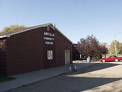 Location within the state of North Dakota
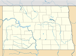
 Arvilla
Coordinates: 47°55′9″N 97°29′41″W / 47.91917°N 97.49472°WCoordinates: 47°55′9″N 97°29′41″W / 47.91917°N 97.49472°W Country United States State North Dakota County Grand Forks Elevation 1,004 ft (306 m) Time zone Central (CST) (UTC-6) - Summer (DST) CDT (UTC-5) ZIP codes 58214 FIPS code GNIS feature ID 1027748 Arvilla (also Orange) is an unincorporated community in central Grand Forks County, North Dakota, United States. It lies along U.S. Route 2 west of the city of Grand Forks, the county seat of Grand Forks County.[1] Its elevation is 1,004 feet (306 m). The community was first named Orange for Orange County, New York; it was renamed Arvilla for Arvilla Estella Hersey, the wife of a local farmer.[2] Although it is unincorporated, it has a post office, with the ZIP code of 58214.[3]
References
- ^ Rand McNally. The Road Atlas '08. Chicago: Rand McNally, 2008, p. 77.
- ^ U.S. Geological Survey Geographic Names Information System: Arvilla, North Dakota, Geographic Names Information System, 1980-02-13. Accessed 2008-03-28.
- ^ Zip Code Lookup
Municipalities and communities of Grand Forks County, North Dakota County seat: Grand Forks Cities 
Townships Agnes | Allendale | Americus | Arvilla | Avon | Bentru | Blooming | Brenna | Chester | Elkmount | Elm Grove | Fairfield | Falconer | Ferry | Gilby | Grace | Grand Forks | Hegton | Inkster | Johnstown | Lakeville | Larimore | Levant | Lind | Logan Center | Loretta | Mekinock | Michigan | Moraine | Niagara | Northwood | Oakville | Pleasant View | Plymouth | Rye | Strabane | Turtle River | Union | Walle | Washington | Wheatfield
CDP Unincorporated
communitiesArvilla | Calspur | Kelly | Mekinock | Merrifield | North Grand Forks | Oakville | Ojata | Powell
Footnotes ‡This populated place also has portions in an adjacent county or counties
Categories:- North Dakota geography stubs
- Populated places in Grand Forks County, North Dakota
- Unincorporated communities in North Dakota


Wikimedia Foundation. 2010.