- McGregor, North Dakota
-
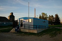
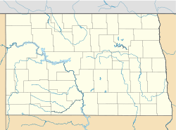
McGregor — Unincorporated community — Post office in McGregor Location within the state of North Dakota Coordinates: 48°35′43″N 102°55′42″W / 48.59528°N 102.92833°WCoordinates: 48°35′43″N 102°55′42″W / 48.59528°N 102.92833°W Country United States State North Dakota County Williams Elevation 2,218 ft (676 m) Time zone Central (CST) (UTC-6) - Summer (DST) CDT (UTC-5) ZIP codes 58755 FIPS code GNIS feature ID 1030143 McGregor is an unincorporated community in northeastern Williams County, North Dakota, United States. It lies along North Dakota Highway 40 northeast of the city of Williston, the county seat of Williams County.[1] Its elevation is 2,218 feet (676 m).[2] Although it is unincorporated, it has a post office, with the ZIP code of 58755.[3]
References
- ^ Rand McNally. The Road Atlas '08. Chicago: Rand McNally, 2008, p. 77.
- ^ U.S. Geological Survey Geographic Names Information System: McGregor, North Dakota, Geographic Names Information System, 1980-02-13. Accessed 2008-03-31.
- ^ Zip Code Lookup
Municipalities and communities of Williams County, North Dakota County seat: Williston Cities Townships Athens | Barr Butte | Big Meadow | Big Stone | Blacktail | Blue Ridge | Bonetraill | Brooklyn | Buford | Bull Butte | Champion | Climax | Dry Fork | Dublin | East Fork | Ellisville | Equality | Farmvale | Golden Valley | Good Luck | Grenora | Hardscrabble | Hazel | Hebron | Judson | Lindahl | Marshall | Missouri Ridge | Mont | New Home | Oliver | Orthell | Pleasant Valley | Rainbow | Rock Island | Round Prairie | Sauk Valley | Scorio | South Meadow | Springbrook | Stony Creek | Strandahl | Tioga | Trenton | Truax | Twelve Mile | Tyrone | View | West Bank | Wheelock | Williston | Winner
Unorganized
territoriesCow Creek | Southeast Williams
Unincorporated
communitiesCategories:- North Dakota geography stubs
- Populated places in Williams County, North Dakota
- Unincorporated communities in North Dakota
Wikimedia Foundation. 2010.


