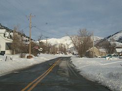
- Ophir, Utah
-
Ophir, Utah — Town — Ophir in winter Location of Ophir, UtahCoordinates: 40°22′9″N 112°15′31″W / 40.36917°N 112.25861°WCoordinates: 40°22′9″N 112°15′31″W / 40.36917°N 112.25861°W Country United States State Utah County Tooele Named for Ophir Area – Total 0.2 sq mi (0.4 km2) – Land 0.2 sq mi (0.4 km2) – Water 0.0 sq mi (0.0 km2) Elevation 6,496 ft (1,980 m) Population (2000) – Total 23 – Density 143.0/sq mi (55.2/km2) Time zone Mountain (MST) (UTC-7) – Summer (DST) MDT (UTC-6) ZIP code 84071 Area code(s) 435 FIPS code 49-56750[1] GNIS feature ID 1431015[2] Ophir is a town in Tooele County, Utah, United States. It is part of the Salt Lake City, Utah Metropolitan Statistical Area. The population was 23 at the 2000 census, a decrease of two from the 1990 figure of 25.
Contents
History
Ophir was named for the nearby canyon and mining district, where gold was discovered in the 1860s. The mining district was named for the biblical Ophir, from where King Solomon brought back gold to Israel.
Geography
Ophir is located at 40°22′9″N 112°15′31″W / 40.36917°N 112.25861°W (40.369102, -112.258534).[3]
According to the United States Census Bureau, the town has a total area of 0.2 square miles (0.4 km²), all of it land.
Demographics
Historical populations Census Pop. %± 1890 249 — 1900 295 18.5% 1910 283 −4.1% 1920 522 84.5% 1930 170 −67.4% 1940 300 76.5% 1950 199 −33.7% 1960 36 −81.9% 1970 76 111.1% 1980 42 −44.7% 1990 25 −40.5% 2000 23 −8.0% As of the census[1] of 2000, there were 23 people, 10 households, and 6 families residing in the town. The population density was 143.0 people per square mile (55.5/km²). There were 33 housing units at an average density of 205.1 per square mile (79.6/km²). The racial makeup of the town was 95.65% White and 4.35% Asian.
There were 10 households out of which 20.0% had children under the age of 18 living with them, 60.0% were married couples living together, and 40.0% were non-families. 40.0% of all households were made up of individuals and 20.0% had someone living alone who was 65 years of age or older. The average household size was 2.30 and the average family size was 3.17.
In the town the population was spread out with 8.7% under the age of 18, 8.7% from 18 to 24, 8.7% from 25 to 44, 43.5% from 45 to 64, and 30.4% who were 65 years of age or older. The median age was 54 years. For every 100 females there were 109.1 males. For every 100 females age 18 and over, there were 110.0 males.
The median income for a household in the town was $50,000, and the median income for a family was $49,167. Males had a median income of $46,875 versus $13,750 for females. The per capita income for the town was $29,906. None of the population or families were below the poverty line.
References
- ^ a b "American FactFinder". United States Census Bureau. http://factfinder.census.gov. Retrieved 2008-01-31.
- ^ "US Board on Geographic Names". United States Geological Survey. 2007-10-25. http://geonames.usgs.gov. Retrieved 2008-01-31.
- ^ "US Gazetteer files: 2010, 2000, and 1990". United States Census Bureau. 2011-02-12. http://www.census.gov/geo/www/gazetteer/gazette.html. Retrieved 2011-04-23.
Municipalities and communities of Tooele County, Utah Cities Towns Ophir | Rush Valley | Stockton | Vernon
CDPs Dugway | Erda | Stansbury Park
Unincorporated
communitiesBurmester | Ibapah | Lake Point
Ghost towns Categories:- Populated places in Tooele County, Utah
- Towns in Utah
- Salt Lake City metropolitan area
- Mining communities in Utah
Wikimedia Foundation. 2010.


