- 2001 Pacific hurricane season
Infobox hurricane season
Basin=EPac
Year=2001
Track=2001 Pacific hurricane season map.pngMay 25 ,2001
Last storm dissipated=November 3 ,2001
Strongest storm name=Juliette
Strongest storm winds=125
Strongest storm pressure=923
Average wind speed=1
Total depressions=19
Total storms=15
Total hurricanes=7
Total intense=2
Fatalities=9
Da
Inflated=1
five seasons=1999, 2000, 2001, 2002, 2003May 15 ,2001 in the eastern Pacific, and onJune 1 ,2001 in the central Pacific, and lasted untilNovember 30 ,2001 . These dates conventionally delimit the period of each year when most tropical cyclones form in the north-easternPacific Ocean . The first storm formed onMay 25 and the last storm dissipated onNovember 3 .There were no significant storms during the 2001 Pacific hurricane season. Hurricanes Adolph and Juliette both reached Category 4 intensity, while Juliette made landfall in
Baja California as a minimal hurricane, causing two deaths.__TOC__eason summary
Overall, the season's activity was generally below-average. A total of 15 named tropical cyclones formed, and eight became hurricanes. Of those eight, two became major hurricanes. Four depressions failed to reach tropical storm strength.
Hurricane Adolph
Infobox Hurricane Small
Basin=EPac
Track=Adolph 2001 track.pngMay 25
Dissipated=June 1
1-min winds=125
Pressure=940May 7 , and was poorly organized. It wasn't untilMay 18 that the storm showed some signs of development in theAtlantic Ocean . On,May 22 the wave crossed over, and onMay 25 it intensified into Tropical Depression One-E, about convert|250|mi|km south-southwest ofAcapulco , Mexico. The system, after drifting a while, intensified into Tropical Storm Adolph the next day. Later, onMay 27 Adolph was upgraded to a hurricane. OnMay 28 Adolph rapidly intensified to Category 4. Two days after, onMay 30 , Adolph went under an eyewall replacement cycle, and weakened to a convert|115|mi/h|km/h|abbr=on hurricane. This trend of weakening continued, and deteriorated into a tropical storm. Passing over cooler waters, and stable air, Adolph dissipated onJune 1 .cite web|author=Stacy R. Stewart|year=2001|title=Hurricane Adolph Tropical Cyclone Report|publisher=National Hurricane Center|accessdate=2007-07-16|url=http://www.nhc.noaa.gov/2001adolph.html]
* NHC [http://www.nhc.noaa.gov/2001adolph.html archive] for Adolph.Tropical Storm Barbara
Infobox Hurricane Small
Basin=EPac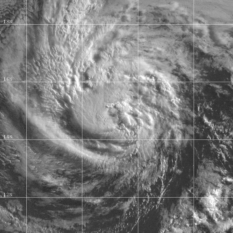
Track=Barbara 2001 track.pngJune 20
Dissipated=June 26
1-min winds=50
Pressure=997Africa onJune 1 . The wave eventually entered thePacific Ocean onJune 10 . Finally, onJune 18 development was beginning to appear. Slow changes occurred over the next two days, and led to the development of Tropical Depression Two-E onJune 20 . Tropical Depression Two-E began a north-westwardly motion for the rest of its lifetime. Later that day, Tropical Depression Two-E intensified to Tropical Storm Barbara, and reached its peak onJune 21 .Increasing south-westerly vertical shear caused weakening, and Barbara became a depression as it crossed 140W into the Central Pacific. The depression passed north of the Hawaiian Islands on
June 25 , then weakened to an easterly wave to the northwest of Kauai onJune 26 . The remnants of Barbara continued west-northwest until being absorbed by a frontal zone near the International Dateline onJune 30 .cite web|author=Jack Beven
year=2001|title=Tropical Storm Barbara Tropical Cyclone Report|publisher=National Hurricane Center|accessdate=2007-07-16|url=http://www.nhc.noaa.gov/2001barbara.html]
* NHC [http://www.nhc.noaa.gov/2001barbara.html archive] for Barbara.Tropical Storm Cosme
Infobox Hurricane Small
Basin=EPac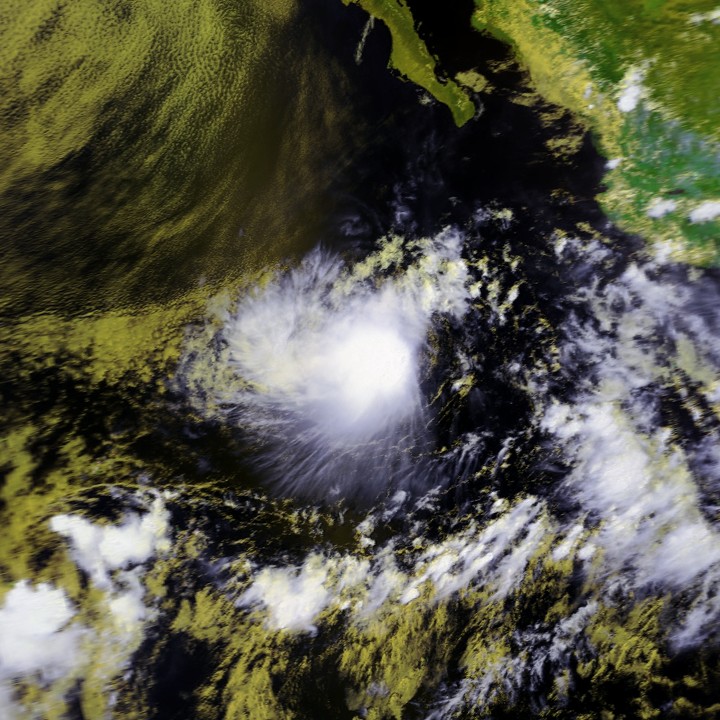
Track=Cosme 2001 track.pngJuly 13
Dissipated=July 15
1-min winds=40
Pressure=1000July 6 .The wave moved slowly westward fromJuly 6 -July 10 . On the 10th, the convective pattern began to show signs of organization about convert|350|nmi|km south ofAcapulco , Mexico, and the system received its first Dvorak satellite classification. Over the next two days, the system moved generally west-northwestward as multiple low-level circulations developed within a broad area of low pressure. During this period, development of the disturbance was hindered by southerly shear from an upper-level trough to the west of the disturbance that caused the system to become elongated north-south. On the 12th, the upper trough cut off southwest of the disturbance and the organization improved. By early on the 13th, a single low-level circulation center had become established and it is estimated that a tropical depression formed at convert|330|mi|km southwest of Manzanillo, Mexico.Tropical Depression Three-E moved west-northwestward, and quickly became Tropical Storm Cosme on the 13th, about convert|425|mi|km south of
Cabo San Lucas, Mexico . The forward motion then slowed over the next 12 hours. Cosme's development was hindered by easterly shear; its peak intensity of convert|40|kn|km/h|abbr=on was reached late on the 13th. By early on the 14th, convection was limited and well removed from the center. Cosme weakened back to a tropical depression, when it was about convert|400|nmi|km|abbr=on southwest of Cabo San Lucas. Cosme produced no more significant convection after about on the 15th, at which point the tropical cyclone became a non-convective low center. The low then moved slowly westward until it dissipated on the 18th about convert|820|mi|km west-southwest ofCabo San Lucas, Mexico .cite web|author=James L. Franklin|year=2001|title=Tropical Storm Cosme Tropical Cyclone Report|publisher=National Hurricane Center|accessdate=2007-07-16|url=http://www.nhc.noaa.gov/2001cosme.html]
* NHC [http://www.nhc.noaa.gov/2001cosme.html archive] for Cosme.Tropical Storm Erick
Infobox Hurricane Small
Basin=EPac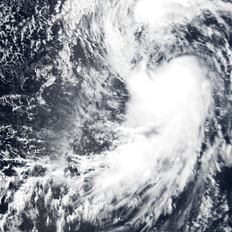
Track=Erick 2001 track.pngJuly 20
Dissipated=July 24
1-min winds=35
Pressure=1001July 16 . The thunderstorm activity associated with the wave increased on the 18th when the disturbance was centered about convert|700|nmi|km|abbr=on south of the southern tip ofBaja California . Thereafter, deep convection gradually developed around a large cyclonic gyre which accompanied the wave.It was not until
July 20 that a well-defined center of circulation formed and satellite intensity estimates supported tropical depression status. Moving on a general west-northwest track, the system became a tropical storm and reached maximum winds of convert|35|kn|km/h and 1001 mbar minimum pressureJuly 22 . It then moved over relatively cooler waters and weakened as the deep convection quickly vanished. ByJuly 24 , it was just a non-convective and dissipating swirl of low clouds, although some showers re-developed intermittently.cite web|author=Lixion A. Avila|year=2001|title=Tropical Storm Erick Tropical Cyclone Report|publisher=National Hurricane Center|accessdate=2007-07-16|url=http://www.nhc.noaa.gov/2001erick.html]
* NHC [http://www.nhc.noaa.gov/2001erick.html archive] for Erick.Hurricane Dalila
Infobox Hurricane Small
Basin=EPac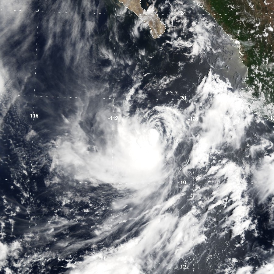
Track=Dalila 2001 track.pngJuly 21
Dissipated=July 28
1-min winds=65
Pressure=982July 10 . It crossed northernSouth America andCentral America on theJuly 15 throughJuly 17 accompanied by vigorous thunderstorm activity, and then entered the Pacific basin on the 18th as an organized area of disturbed weather. Early on the 21st, the system acquired a low-level circulation and became Tropical Depression Five-E, about convert|250|mi|km|abbr=on south of the Gulf Of Tehuantepec. Moving west-northwestward, it became Tropical Storm Dalila with convert|35|kn|km/h winds 12 hours later.Dalila's track was toward the west-northwest at forward speeds between five and convert|15|kn|km/h. The direction of motion was rather steady, varying between 285 and 300 degrees heading. This is attributed to a persistent subtropical ridge of high pressure located north of the cyclone. The center reached its point of closest approach to the coast of Mexico between Acapulco and Manzanillo on the
July 22 andJuly 23 , when it came within about convert|100|mi|km of the coast.With warm
sea surface temperature s and minimal vertical shear, the winds increased from 35 to convert|60|kn|km/h between the 22nd and 23rd. The wind speed briefly reached an estimated convert|75|mi/h|km/h|abbr=on on the 24th. Dalila was a hurricane for only a few hours and then remained at convert|55|kn|km/h until early on the 27th. The storm passed directly over Socorro Island on the 25th. By the 27th, most of the associated deep convection dissipated as the storm moved over colder water. Reduced to a swirl of low clouds, Dalila dissipated as a tropical cyclone onJuly 28 , while located about convert|650|mi|km west of the southern tip of Baja California.cite web|author=Miles B. Lawrence|year=2001|title=Hurricane Dalila Tropical Cyclone Report|publisher=National Hurricane Center|accessdate=2007-07-16|url=http://www.nhc.noaa.gov/2001dalila.html]
* NHC [http://www.nhc.noaa.gov/2001dalila.html archive] for Dalila.Tropical Depression Six-E
Infobox Hurricane Small
Basin=EPac
Track=6-E 2001 track.pngAugust 22
Dissipated=August 24
1-min winds=30
Pressure=1007Africa onAugust 3 . The wave was fairly well organized over the eastern Atlantic, but it weakened and became difficult to identify as it approached the Caribbean Sea onAugust 8 . Based on continuity and extrapolation, the system crossedCentral America on the 12th and 13th. As the wave neared 135W on the 21st, the associated cloud pattern became better organized, and it is estimated that Tropical Depression Six-E formed from this system about convert|1300|mi|km east of the Hawaiian Islands on theAugust 22 . The tropical cyclone moved mostly north-northwestward, and did not strengthen significantly. As a result of south-southwesterly vertical shear, and cooler waters, the depression dissipated by early on theAugust 24 . There were no reports of casualties or damage associated with this system.The tropical cyclone moved mostly north-northwestward, and did not strengthen significantly.cite web|author=Richard J. Pasch|year=2001|title=Tropical Depression Six-E Tropical Cyclone Report|publisher=National Hurricane Center|accessdate=2007-07-16|url=http://www.nhc.noaa.gov/2001six-e.html]
* NHC [http://www.nhc.noaa.gov/2001six-e.html archive] for 6E.Hurricane Flossie
Infobox Hurricane Small
Basin=EPac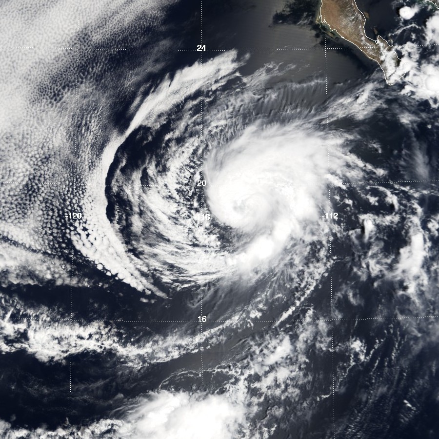
Track=Flossie 2001 track.pngAugust 26
Dissipated=September 2
1-min winds=90
Pressure=972August 26 . The depression moved out to sea and quickly intensified into a tropical storm. The next day, steering currents weakened and Flossie deepened into a hurricane. After a period of binary interaction with an extratropical low, Flossie recurved. A combination ofwind shear and cool waters brought about Flossie's rapid demise, and the hurricane had dissipated bySeptember 2 . Flossie's remnants moved over part of theBaja California Peninsula before dissipating over theU.S. state ofCalifornia .Flossie had no direct impact on land as a hurricane. Its remnants caused flash-flooding in San Diego and Riverside Counties, California. A strong downdraft knocked a tree onto a house. Four people were struck by lightning, two of them fatally. The total cost of damage caused by Flossie's remnants was US$35,000.cite web|author=Stacy R. Stewart|year=2001|title=Hurricane Flossie Tropical Cyclone Report|publisher=National Hurricane Center|accessdate=2007-07-16|url=http://www.nhc.noaa.gov/2001flossie.html]
* NHC [http://www.nhc.noaa.gov/2001flossie.html archive] for Flossie.Hurricane Gil
Infobox Hurricane Small
Basin=EPac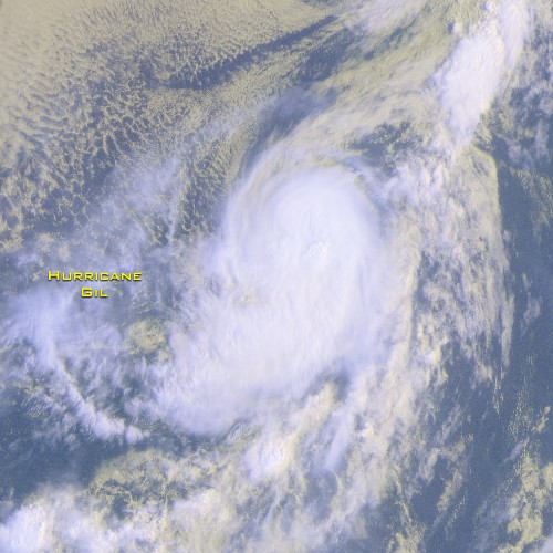
Track=Gil 2001 track.pngSeptember 4
Dissipated=September 9
1-min winds=85
Pressure=975August 21 , with the northern portion of the wave spawning Atlantic Tropical Storm Dean onAugust 22 . The southern portion of the wave continued westward, crossing Central America into the Pacific on August 24th. Little development occurred for the next several days as the wave continued westward. Convection associated with the wave increased on August 30th while large-scale low-level cyclonic turning developed over the tropical eastern Pacific - an environment similar to the Western Pacific monsoon environment. The wave gradually organized over the next few days, and Tropical Depression Eight-E formed nearSeptember 4 about convert|850|mi|km southwest ofCabo San Lucas, Mexico . The cyclone strengthened and became Tropical Storm Gil six hours later. At that time, Tropical Depression Nine-E (which later became Henriette) formed about convert|765|nmi|km to the east of Gil.Gil moved westward with its speed varying from 3-8 knots from
September 4 -September 6 . Steady strengthening occurred during this time, with Gil becoming a hurricane early on the 6th. It reached a peak intensity of convert|100|mi/h|km/h|abbr=on by that day when an eye was visible in both conventional and microwave satellite imagery. At that time the stronger Gil was convert|465|nmi|km southwest of the larger Henriette.Gil turned northwestward early on
September 7 . Later that day it accelerated northward as Henriette began to pass to the north and the two cyclones began interacting in earnest. Gil weakened during this time because the rapid northward motion into the northeasterly upper-level outflow from Henriette caused shear. By the 8th, Henriette was passing convert|330|nmi|km north of Gil and the two cyclones began to rotate around each other. This caused Gil to move at 20-25 knots on a north-northwest track that changed to west on the 9th. Gil weakened steadily during this time and had become a depression by early on the 9th.While Henriette dissipated as a tropical cyclone shortly after on
September 8 about convert|210|nmi|km west of Gil, the remnant low-to-mid level vorticity center continued to move around the south and east sides of Gil. This caused Gil to turn southwestward early on the 9th. Once Henriette was fully absorbed, Gil slowed from a 20-25 knots motion to a westward drift in a few hours. Associated convection totally dissipated during the merger and did not return afterwards. This resulted in Gil dissipating late on the 9th about convert|1000|nmi|km east of the Hawaiian Islands. The remnant low cloud swirl moved generally west-northwestward to northwestward for several days, finally being absorbed by a cold front well to the north of the Hawaiian Islands onSeptember 19 . The next this time this would happen was in the 2005 season, when Hurricane Max absorbed Tropical Storm Lidia.cite web|author=|year=2001|title=Hurricane Gil Tropical Cyclone Report|publisher=National Hurricane Center|accessdate=2007-07-16|url=http://www.nhc.noaa.gov/2001gil.html]
* NHC [http://www.nhc.noaa.gov/2001gil.html archive] for Gil.Tropical Storm Henriette
Infobox Hurricane Small
Basin=EPac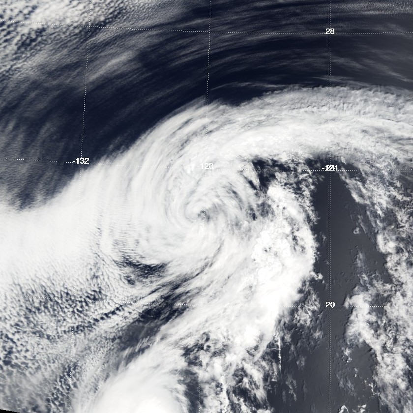
Track=Henriette 2001 track.pngSeptember 4
Dissipated=September 8
1-min winds=55
Pressure=994Central America onAugust 28 -August 19 , began showing some signs of development some hundreds south ofAcapulco , Mexico. Early morning visible satellite images onSeptember 4 revealed a partially exposed, but well defined low-level circulation. While deep convection was confined to the southwestern half of the circulation, the convection was close enough to the center for Dvorak satellite intensity estimates to increase to 25-30 knots, and the system became Tropical Depression Nine-E onSeptember 4 , about convert|300|mi|km west-southwest of Manzanillo, Mexico, and also about convert|765|mi|km east of Tropical Depression Eight-E (which was to become Hurricane Gil). Early onSeptember 5 , as the depression's heading turned to the west, the separation between the circulation center and the deep convection.Tropical Depression Nine-E became Tropical Storm Henriette on
September 5 , about convert|350|mi|km south-southwest ofCabo San Lucas, Mexico . At this time, Tropical Storm Gil was located about convert|690|mi|km to the west of Henriette. Henriette slowly became better organized onSeptember 6 . The convective pattern became more symmetric and the intensity increased to convert|50|kn|km/h. Meanwhile, Henriette turned to the northwest and accelerated to a forward speed of 15-17 knots as it began to feel the influence of Hurricane Gil, then located convert|465|nmi|km|abbr=on to the southwest. Upper-level easterly flow, which was still evident over the cyclone early on the 6th, lessened and a more favorable outflow pattern began to develop. Convective banding near the center became better defined, and Henriette reached its peak intensity of convert|65|mi/h|km/h|abbr=on onSeptember 7 .Tropical Storm Henriette, began weakening due to cold waters, and nearing Gil. A
Fujiwhara interaction began with Henriette and Gil on the 8th. Henriette dissipated as a tropical cyclone when it lost its own closed low-level circulation, as evidenced by low-cloud trajectories, shortly after on the 8th. At the time of dissipation, Henriette was located about convert|210|mi|km west of Tropical Storm Gil. cite web|author=Daniel P. Brown and James L. Franklin|year=2001|title=Tropical Storm Henriette Tropical Cyclone Report|publisher=National Hurricane Center|accessdate=2007-07-16|url=http://www.nhc.noaa.gov/2001henriette.html]
* NHC [http://www.nhc.noaa.gov/2001henriette.html archive] for Henriette.Tropical Storm Ivo
Infobox Hurricane Small
Basin=EPac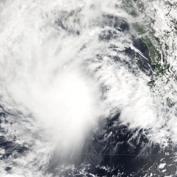
Track=Ivo 2001 track.pngSeptember 10
Dissipated=September 14
1-min winds=45
Pressure=997August 26 . The wave was accompanied by a large cyclonic rotation at the low to middle levels and numerous thunderstorms when it entered the eastern Atlantic. On the 28th, the wave spawned a northward-moving vortex in the eastern Atlantic, but the wave's southern portion continued westward with very limited convective activity. Once the wave reached the western Caribbean Sea onSeptember 5 , the shower activity increased and the whole system continued slowly westward overCentral America . The cloud pattern gradually became better organized and by 9 September, satellite images showed a low to middle level circulation centered near Acapulco, Mexico. The next day, a portion of the system moved over water and it became a tropical depression about convert|100|nmi|km|abbr=on south-southwest of Acapulco atSeptember 10 .The center of the depression moved slowly west and west-northwestward with its circulation hugging the southwest coast of Mexico. There was moderate easterly shear over the depression as indicated by the location of the convection to the west of the center. Satellite images and a report from a ship indicated that the depression reached tropical storm status by 0600 UTC 11 September. Thereafter, there was only slight strengthening and Ivo reached its maximum intensity of convert|50|mi/h|km/h|abbr=on and an estimated minimum pressure of 997 mbar on
September 12 . The tropical storm moved toward the northwest and then west over increasingly cooler waters, and gradually weakened. It became a low pressure system devoid of convection by the end ofSeptember 14 .cite web|author=Lixion A. Avila|year=2001|title=Tropical Storm Ivo Tropical Cyclone Report|publisher=National Hurricane Center|accessdate=2007-07-16|url=http://www.nhc.noaa.gov/2001ivo.html]
* NHC [http://www.nhc.noaa.gov/2001ivo.html archive] for Ivo.Tropical Depression One-C
Infobox Hurricane Small
Basin=EPac
Track=1-C 2001 track.pngSeptember 11
Dissipated=September 11
1-min winds=30
Pressure=1002September 11 more than 400 southeast of the Island of Hawaii. The system moved west northwestward to 15N 153W bySeptember 11 , and then southwestward on September 11. The system was poorly organized, and the convection of Tropical Depression One-C dissipated bySeptember 11 . Having only lasted 12 hours as a depression; Tropical Depression One-C never reached tropical storm strength.cite web|author=Robert W. Kelly, Treena Loos and Kevin R. Kodama|year=2001|title=Tropical Depression One-C Tropical Cyclone Report|publisher=National Hurricane Center|accessdate=2007-07-16|url=http://www.prh.noaa.gov/cphc/summaries/2001.php#td1c.html]
* CPHC [http://www.prh.noaa.gov/cphc/summaries/2001.php#td1c archive] for 1C.Hurricane Juliette
Infobox Hurricane Small
Basin=EPac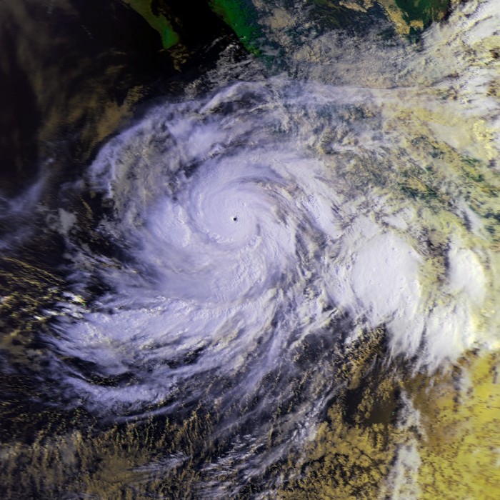
Track=Juliette 2001 track.pngSeptember 21
Dissipated=October 3
1-min winds=125
Pressure=923September 21 . Sustained intensification began the next day. Juliette eventually peaked as a Category 4 hurricane with a central pressure of 923 millibars, which made it the fifth-most intense Pacific hurricane at the time. Juliette turned north and weakened and made landfall as a minimal hurricane. Juliette's remnants hung on for a few more days until they dissipated onOctober 3 .Juliette dumped heavy rains on the
Baja California Peninsula and inSonora , where it caused two deaths. Its effects were especially hard onCabo San Lucas ,Baja California Sur , which was cut off from the outside world for a few days. The remnants of Juliette moved into the state ofCalifornia , where they caused thunderstorms, rain, and some downed power lines. The total estimated cost of damage was 15 million dollars.cite web|author=Miles B. Lawrence and Michelle M. Mainelli|year=2001|title=Hurricane Juliette Tropical Cyclone Report|publisher=National Hurricane Center|accessdate=2007-07-16|url=http://www.nhc.noaa.gov/2001juliette.html]
* NHC [http://www.nhc.noaa.gov/2001juliette.html archive] for Juliette.Hurricane Kiko
Infobox Hurricane Small
Basin=EPac
Track=Kiko 2001 track.pngSeptember 21
Dissipated=September 25
1-min winds=65
Pressure=990September 7 also seems to have produced Kiko. This wave moved westward at low latitudes, crossing northern South America onSeptember 13 -September 14 andCentral America on the 15th and 16th. BySeptember 17 , cloudiness and showers increased near the Gulf of Tehuantepec. The area of disturbed weather moved westward for the next few days, without much increase in organization. OnSeptember 21 , the system's cloud pattern became more consolidated, and curved bands of showers were evident. It is estimated that Tropical Depression Twelve-E had formed that day, at which time it was centered about convert|550|nmi|km|abbr=on southwest of the southern tip of Baja California.After forming, the system, which was located in an environment of easterly vertical shear, strengthened slowly. By
September 22 the organization of the cloud pattern improved to the extent that tropical storm strength was estimated to have been reached. Kiko turned from a northwestward to a west-northwestward heading that day. Although some easterly shear continued to affect the system, very deep convection persisted near the center, and based on Dvorak intensity estimates, Kiko strengthened into a hurricane aroundSeptember 23 . A little later on the 23rd, deep convection decreased in coverage and intensity and Kiko weakened back to a tropical storm.The system continued to lose intensity on the 24th, at least in part due to the entrainment of more stable air at low levels. Kiko weakened to a tropical depression on the 25th, by which time southwesterly shear also became prevalent. Later on the 25th, the cyclone degenerated into a westward-moving swirl of low clouds with little or no deep convection. Kiko's remnant low persisted and continued moving generally westward for several more days with intermittent, minor occurrences of deep convection within the circulation. It was finally absorbed into a frontal system to the northeast of the Hawaiian Islands on
October 1 .cite web|author=Richard J. Pasch|year=2001|title=Hurricane Kiko Tropical Cyclone Report|publisher=National Hurricane Center|accessdate=2007-07-16|url=http://www.nhc.noaa.gov/2001kiko.html]
* NHC [http://www.nhc.noaa.gov/2001kiko.html archive] for Kiko.Tropical Depression Two-C
Infobox Hurricane Small
Basin=EPac
Track=2-C 2001 track.pngSeptember 23
Dissipated=September 25
1-min winds=30
Pressure=1008September 22 , southwest of Tropical Storm Kiko (in the East Pacific). ThroughoutSeptember 23 , Tropical Depression Two-C remained a poorly organized system that slowly moved west-northwestward. A slight increase in convection became apparent onSeptember 24 , and was followed by a period of consistent thunderstorm activity near the circulation center. Tropical Depression Two-C continued in the west-northwest direction, but weakened bySeptember 25 .cite web|author=Robert W. Kelly, Treena Loos and Kevin R. Kodama|year=2001|title=Tropical Depression Two-C Tropical Cyclone Report|publisher=National Hurricane Center|accessdate=2007-07-16|url=http://www.prh.noaa.gov/cphc/summaries/2001.php#td2c.html]
* CPHC [http://www.prh.noaa.gov/cphc/summaries/2001.php#td2c archive] for 2C.Tropical Storm Lorena
Infobox Hurricane Small
Basin=EPac
Track=Lorena 2001 track.pngOctober 2
Dissipated=October 4
1-min winds=50
Pressure=997Africa onSeptember 13 . The poorly-defined wave tracked rapidly westward across the Atlantic for more than a week. There was little or no thunderstorm activity associated with the wave until it moved across Central America onSeptember 27 . Significant deep convection finally developed onSeptember 29 and satellite classifications began onSeptember 30 when the system was located about convert|300|mi|km south ofAcapulco , Mexico. The wave possessed a well-defined closed low-level circulation at that time.Convection steadily increased and banding features developed during the day on 1 October. Satellite intensity estimates indicate the system became Tropical Depression Thirteen-E at
October 2 . Low-level circulation had tightened up considerably and satellite intensity estimates indicated the depression had strengthened into Tropical Storm Lorena about convert|350|mi|km south-southwest of Acapulco. Lorena tracked steadily west-northwestward at 8 to convert|12|kn|km/h the remainder of the day and gradually turned toward the northwest early on 3 October. The peak intensity of convert|60|mi/h|km/h|abbr=on occurred later that day as Lorena took a more northerly track when it was located about convert|180|nmi|km|abbr=on southwest of Manzanillo, Mexico.By
October 4 , Lorena's forward speed had decreased to around 6 to convert|8|kn|km/h and strong upper-level southwesterly shear began to adversely affect the cyclone. Lorena weakened to a tropical depression and dissipated into a non-convective low later that day about convert|120|mi|km southwest ofPuerto Vallarta, Mexico . The remnant low-level cloud circulation remained offshore and persisted for another day or so before completely dissipating just west of Cabo Corrientes, Mexico.cite web|author=Stacy R. Stewart|year=2001|title=Tropial Storm Lorena Tropical Cyclone Report|publisher=National Hurricane Center|accessdate=2007-07-16|url=http://www.nhc.noaa.gov/2001lorena.html]
* NHC [http://www.nhc.noaa.gov/2001lorena.html archive] for Lorena.Tropical Depression Fourteen-E
Infobox Hurricane Small
Basin=EPac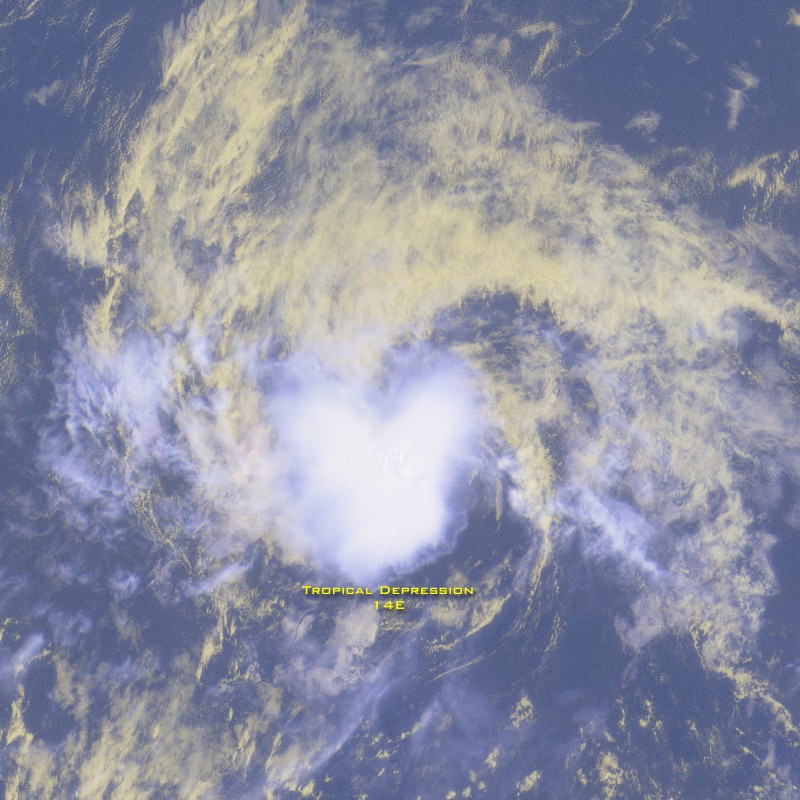
Track=14-E 2001 track.pngOctober 3
Dissipated=October 4
1-min winds=30
Pressure=1008September 30 . The swirl moved westward with little development until 2 October when it started to generate convection. Satellite intensity estimates indicate the system became Tropical Depression Fourteen-E onOctober 3 about convert|800|mi|km southwest of the southern tip of Baja California. The convection did not persist as the system moved westward to west-northwestward, and the cyclone dissipated early onOctober 4 about convert|900|mi|km southwest of the southern tip of Baja California. The remnant low cloud swirl continued westward for another 24-36 hours before dissipating completely.
* NHC [http://www.nhc.noaa.gov/2001fourteen-e.html archive] for 14E.cite web|author=Jack Beven|year=2001|title=Tropical Depression Fourteen-E Tropical Cyclone Report|publisher=National Hurricane Center|accessdate=2007-07-16|url=http://www.nhc.noaa.gov/2001fourteen-e.html]Tropical Storm Manuel
Infobox Hurricane Small
Basin=EPac
Track=Manuel 2001 track.pngOctober 10
Dissipated=October 18
1-min winds=50
Pressure=997Hurricane Iris from the Atlantic Basin. The core circulation of Iris had dissipated over the mountains of eastern Mexico, while new convection was developing a short distance away over the waters of the Pacific. This area became better organized over the next 18 hours and became Tropical Depression Fifteen-E atOctober 10 , about convert|175|mi|km south-southeast ofAcapulco , Mexico. The depression moved at 13-14 knots, first westward and then west-northwestward. An upper-level anticyclone centered over southern Mexico was producing some easterly shear in the environment of the depression, but when this shear lessened the system became Tropical Storm Manuel onOctober 11 , about convert|200|mi|km south-southwest of Zihuatanejo, Mexico. An estimated initial peak intensity of convert|45|kn|km/h was reached that day when the first clear banding features developed. However, the banding was short-lived, deep convection diminished, and satellite microwave imagery early on 12 October suggested that the circulation was becoming elongated. Wind shear returned, this time from the northwest, and Manuel turned to a west-southwesterly track and slowed. ByOctober 12 , Manuel had weakened to a tropical depression.Manuel remained a disorganized depression for the next two and a half days. It continued moving to the west-southwest, but slowed to a drift as a mid-level ridge to the north of the cyclone gradually weakened. An upper-level trough dug southward to the west of Manuel early on
October 15 , and Manuel began to move to the north-northwest. Convection redeveloped near the center and Manuel regained tropical storm strength onOctober 15 about convert|520|nmi|km|abbr=on south-southwest ofCabo San Lucas, Mexico . Wind shear decreased and Manuel strengthened, reaching its peak intensity of convert|60|mi/h|km/h|abbr=on winds, and a pressure of 997 mbar onOctober 16 about convert|540|mi|km southwest of Cabo San Lucas. By this point, water temperatures under the cyclone were decreasing and shear, this time from the southwest, was increasing. Manuel began to weaken while moving to the west-northwest and northwest. It became a depression atOctober 17 about convert|660|mi|km west-southwest of Cabo San Lucas, and dissipated to a non-convective low shortly afterOctober 18 . The remnant low moved slowly westward for a couple of days over cool waters before its circulation dissipated completely.cite web|author=James L. Franklin|year=2001|title=Tropical Storm Manuel Tropical Cyclone Report|publisher=National Hurricane Center|accessdate=2007-07-16|url=http://www.nhc.noaa.gov/2001manuel.html]
* NHC [http://www.nhc.noaa.gov/2001manuel.html archive] for Manuel.Hurricane Narda
Infobox Hurricane Small
Basin=EPac
Track=Narda 2001 track.pngOctober 20
Dissipated=October 25
1-min winds=75
Pressure=980Dakar, Senegal around theOctober 3 . The wave became convectively active after it crossedCentral America when it produced a large burst of convection in theBay of Campeche on theOctober 15 . The southern portion of the wave continued westward over the Pacific waters south of Mexico and under favorable upper-level winds, it began to acquire banding features and several centers of circulation. The system finally consolidated and developed one center atOctober 20 . It became a tropical depression about convert|1150|mi|km southwest ofCabo San Lucas, Mexico . Moving on a west-northwest track, it intensified and reached tropical storm status later that day. The cloud pattern continued to become better organized and visible satellite imagery showed an intermittent eye feature, and it is estimated that Narda became a hurricane atOctober 21 . Narda peak's intensity of 980 mbar occurred onOctober 22 . Thereafter, a gradual weakening began and strong shear took a toll on Narda. The tropical cyclone became a tight swirl of low clouds with intermittent convection on the 24th, as it moved westward steered by the low-level flow and crossing 140 W over theCentral Pacific area of responsibility. It then continued westward as a tropical depression until dissipation.cite web|author=Lixion A. Avila|year=2001|title=Hurricane Narda Tropical Cyclone Report|publisher=National Hurricane Center|accessdate=2007-07-16|url=http://www.nhc.noaa.gov/2001narda.html]
* NHC [http://www.nhc.noaa.gov/2001narda.html archive] for Narda.Hurricane Octave
Infobox Hurricane Small
Basin=EPac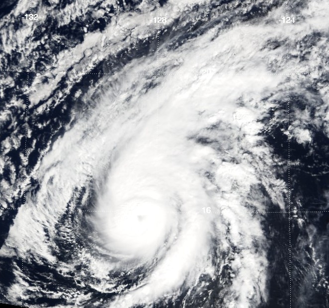
Track=Octave 2001 track.pngOctober 31
Dissipated=November 3
1-min winds=75
Pressure=980Central America onOctober 22 . By the 27th, convection had increased over a large area between 95 - 115 degrees west longitude and between 8 - 15 degrees north latitude. A low-level circulation gradually developed within this area and became a tropical depression on the 31st while centered about convert|1000|nmi|km|abbr=on southwest of the southern tip ofBaja California . The cyclone started out to the south of a mid-layer ridge, but a weakness soon developed in this ridge from a trough approaching from the west. This resulted in a general northwestward track. More specifically, the cyclone moved toward the west-northwest onOctober 31 , followed by a turn toward the north-northwest on the 1st. On the 3rd, low-level steering turned it back toward the west-northwest.Under light vertical shear for 48 hours, the depression gradually strengthened to a convert|75|kn|km/h|sing=on hurricane by
November 1 , with a ragged eye visible for a few hours on satellite images. Vertical shear began increasing on the 1st and reached 30-35 knots on the 3rd. During this period, Octave weakened from a convert|75|kn|km/h|sing=on hurricane to a dissipating swirl of low clouds on the 3rd, located about convert|1300|nmi|km|abbr=on west-southwest of the southern tip ofBaja California .cite web|author=Miles B. Lawrence|year=2001|title=Hurricane Octave Tropical Cyclone Report|publisher=National Hurricane Center|accessdate=2007-07-16|url=http://www.nhc.noaa.gov/2001octave.html]
* NHC [http://www.nhc.noaa.gov/2001octave.html archive] for Octave.torm names
The following names were used for named storms that formed in the northeast Pacific in 2001. The names not retired from this list will be used again in the
2007 Pacific hurricane season . This is the same list used for the 1995 season except for Ivo, which replaced Ismael. A storm was named Ivo for the first time in 2001. No central Pacific names were used; the first name used would have been Alika. Names that were not assigned are marked in gray.Retirement
Adolph was removed following the 2001 season for political reasons, due to the name's similarity to
Adolf Hitler . It was replaced in the 2007 Pacific hurricane season by Alvin.Israel was also removed from the list during the season. It originally replaced Ismael, but due to its connection with
Israel and the unfortunate coincidence that the first name of 2001 was Adolph, this was changed to Ivo after the season began, but before it reached the "I" storm.ee also
*
List of Pacific hurricanes
*List of Pacific hurricane seasons
*2001 Atlantic hurricane season
*2001 Pacific typhoon season
*2001 North Indian Ocean cyclone season
*South-West Indian Ocean cyclone seasons: 2000–01, 2001–02
*Australian region cyclone seasons: 2000–01, 2001–02
*South Pacific cyclone seasons: 2000–01, 2001–02References
External links
* [http://www.nhc.noaa.gov/2001epac.html NHC 2001 Pacific hurricane season archive]
* [http://www.hpc.ncep.noaa.gov/tropical/rain/2001.html HPC 2001 Tropical Cyclone Rainfall Pages]
* [http://www.prh.noaa.gov/hnl/cphc/ Central Pacific Hurricane Center]
* [http://www.typhoon2000.ph/garyp_mgtcs/ Gary Padgett's monthly storm summaries and best tracks]

Wikimedia Foundation. 2010.