- List of storms in the 2001 Atlantic hurricane season
The
2001 Atlantic hurricane season officially began onJune 1 ,2001 , and lasted untilNovember 30 ,2001 . These dates conventionally delimit the period of each year when mosttropical cyclone s form in theAtlantic basin . This was the second year of a two-season stretch with no landfalling hurricanes in theUnited States , which is highly unusual; the previous instance involved the 1981 and 1982 hurricane seasons.Notable 2001 storms include
Tropical Storm Allison ,Hurricane Iris , andHurricane Michelle . Allison caused billions of dollars of damages when it caused flooding inHouston, Texas . Iris caused widespread damage inBelize when it made landfall at Category 4 strength. Michelle was responsible for numerous deaths and large-scale damage inJamaica ,Cuba ,Honduras , andNicaragua .An unusual spree of named storms with interrupted tracks occurred in 2001, with four identified tropical cyclones degenerating below tropical depression strength and reforming. This season was very active during the last months of the year, and holds the record for the number of hurricanes forming in November, with three (Michelle, Noel and Olga).
Storms
Tropical Storm Allison
Infobox Hurricane Small
Basin=Atl
Track=Allison 2001 track.pngJune 5
Dissipated=June 17
1-min winds=50
Pressure=1000Texas in early June. It stalled over the state, moved southward, eastward, hitLouisiana , and continued through the northeast. Allison eventually became extratropical on the 18th, after causing heavy flooding throughout its path, especially in Texas and Louisiana. [cite web|author=Stewart, Stacy R.|year=2001|title=Tropical Storm Allison Tropical Cyclone Report|publisher=National Hurricane Center |accessdate=2008-09-19|url=http://www.nhc.noaa.gov/2001allison.html]Although a minimal storm and barely tropical, Allison is one of the costliest and deadliest tropical cyclones to affect the United States, and the worst tropical storm on record in that nation. FEMA estimated damages at $5 billion, nearly all of it related to freshwater flooding in the
Greater Houston region. There are 41 deaths directly attributable to Allison, 27 of them due to flooding.Tropical Depression Two
Infobox Hurricane Small
Basin=Atl.jpg)
Track=2-L 2001 track.pngJuly 11
Dissipated=July 12
1-min winds=25
Pressure=1010July 11 , about 1150 miles (1850 km) east of theWindward Islands . It attained a maximum strength of convert|30|mi/h|km/h|abbr=on, with a minimum pressure of 1010 mbar. When it first formed, it was forecast to become a tropical storm, but vertical wind shear from a subtropical ridge to the north caused it to dissipate onJuly 12 .Tropical Storm Barry
Infobox Hurricane Small
Basin=Atl.jpg)
Track=Barry 2001 track.pngAugust 2
Dissipated=August 7
1-min winds=60
Pressure=990August 2 . Moving westward, it weakened to a tropical depression, and was expected to continue to the west-northwest. Instead, the ridge to Barry's north degraded, allowing the system to turn northward and restrengthen to tropical storm strength on the 5th. It peaked that night at convert|70|mi/h|km/h|abbr=on, but some southwesterly shear prevented the storm from reaching hurricane strength. Barry made landfall nearSanta Rosa Beach, Florida onAugust 6 as a strong tropical storm with a developing eyewall, leading to the possibility of Barry being a hurricane. After making landfall, the remnants of Barry continued inland, and dissipated overMissouri on the 8th.cite web|author=Jack Beven|title=Tropical Cyclone Report: Tropical Storm Barry|date=April 22, 2001|publisher=National Hurricane Center|accessdate=2008-07-17|url=http://www.nhc.noaa.gov/2001barry.html]Tropical Storm Barry was responsible for two deaths in Florida, one due to a lightning strike. Another indirect death was also reported. Damage is estimated at $30 million. The tropical wave that eventually became Barry is blamed for capsizing a boat carrying Cuban refugees, and six of the passengers drowned.
Tropical Storm Chantal
Infobox Hurricane Small
Basin=Atl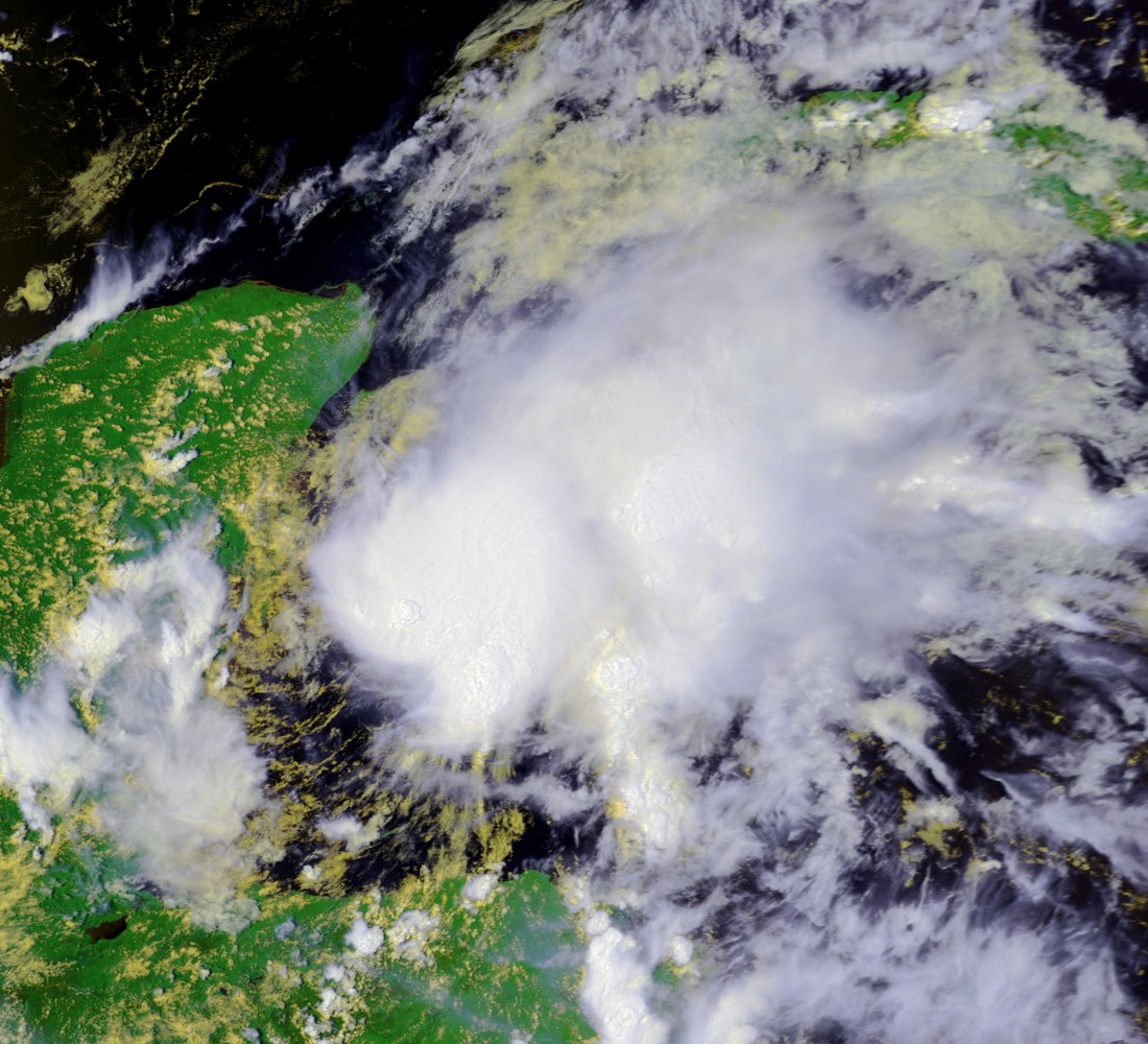
Track=Chantal 2001 track.pngAugust 14
Dissipated=August 22
1-min winds=60
Pressure=997August 14 while well east of the Windward Islands. Sometime on the 16th, the depression degenerated into a tropical wave. This wave passed over the islands, and on the 17th, reformed at tropical storm strength.cite web|author=Franklin, James|date=2001-09-06|title=Tropical Storm Chantal Tropical Cyclone Report|publisher=National Hurricane Center|accessdate=2008-05-08|url=http://www.nhc.noaa.gov/2001chantal.html]Tropical Storm Chantal continued west across the Caribbean Sea, and strengthened somewhat. It was near hurricane strength on
August 21 , but made landfall at the border betweenBelize andMexico before it could gain the necessary wind speed. Chantal continued into Mexico and dissipated on the 22nd.Chantal officially caused no deaths, but the tropical wave caused two deaths from lightning on
Trinidad . Damage in Belize was estimated at $4 million. No significant damages were reported in Mexico.Tropical Storm Dean
Infobox Hurricane Small
Basin=Atl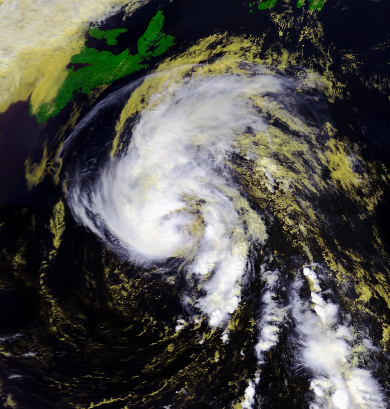
Track=Dean 2001 track.pngAugust 22
Dissipated=August 28
1-min winds=60
Pressure=994August 22 , as it approached theU.S. Virgin Islands , the wave was named Tropical Storm Dean. As Dean left the Caribbean, it weakened, and by the 23rd had degenerated to a tropical wave.The wave held together, and by the 27th had restrengthened back into a tropical storm. Dean approached hurricane strength, but moved over cool water and became extratropical. It was absorbed by a non-tropical low on
August 29 .Heavy rainfall from Dean in
Puerto Rico caused $7.7 million in damage, as well as flooding homes and causing two bridges to collapse. Damage in the Virgin Islands was minimal.Hurricane Erin
Infobox Hurricane Small
Basin=Atl
Track=Erin 2001 track.pngSeptember 1
Dissipated=September 15
1-min winds=105
Pressure=968September 2 . It moved west for several days, but weakened into an area of disturbed weather on the 5th. The storms regenerated, and on the 7th Erin regained tropical storm status. Erin continued to the northwest, and strengthened into a hurricane. OnSeptember 8 , Erin came within convert|90|nmi|km|abbr=on of Bermuda.After passing Bermuda, Erin continued northwest, but on the 11th its track turned sharply east. On the 13th, Erin began heading northeast and grazed
Cape Race , Newfoundland onSeptember 15 . It became extratropical and merged with another system over Greenland on the 17th.No damages or fatalities were reported in relation to Erin.
Hurricane Felix
Infobox Hurricane Small
Basin=Atl
Track=Felix 2001 track.pngSeptember 7
Dissipated=September 19
1-min winds=100
Pressure=962September 7 while near theCape Verde islands. It moved rapidly to the west, and degenerated to a tropical wave the next day. BySeptember 10 , the wave had reorganized, and it was again named Tropical Depression Seven. The depression continued to strengthen, and became Hurricane Felix bySeptember 13 . Now moving north, Felix intensified rapidly, reaching Category 3 status. Felix turned to the northeast and began to weaken. BySeptember 17 , Felix had dropped to tropical storm strength, and it dissipated on the 19th. No damage was reported.Hurricane Gabrielle
Infobox Hurricane Small
Basin=Atl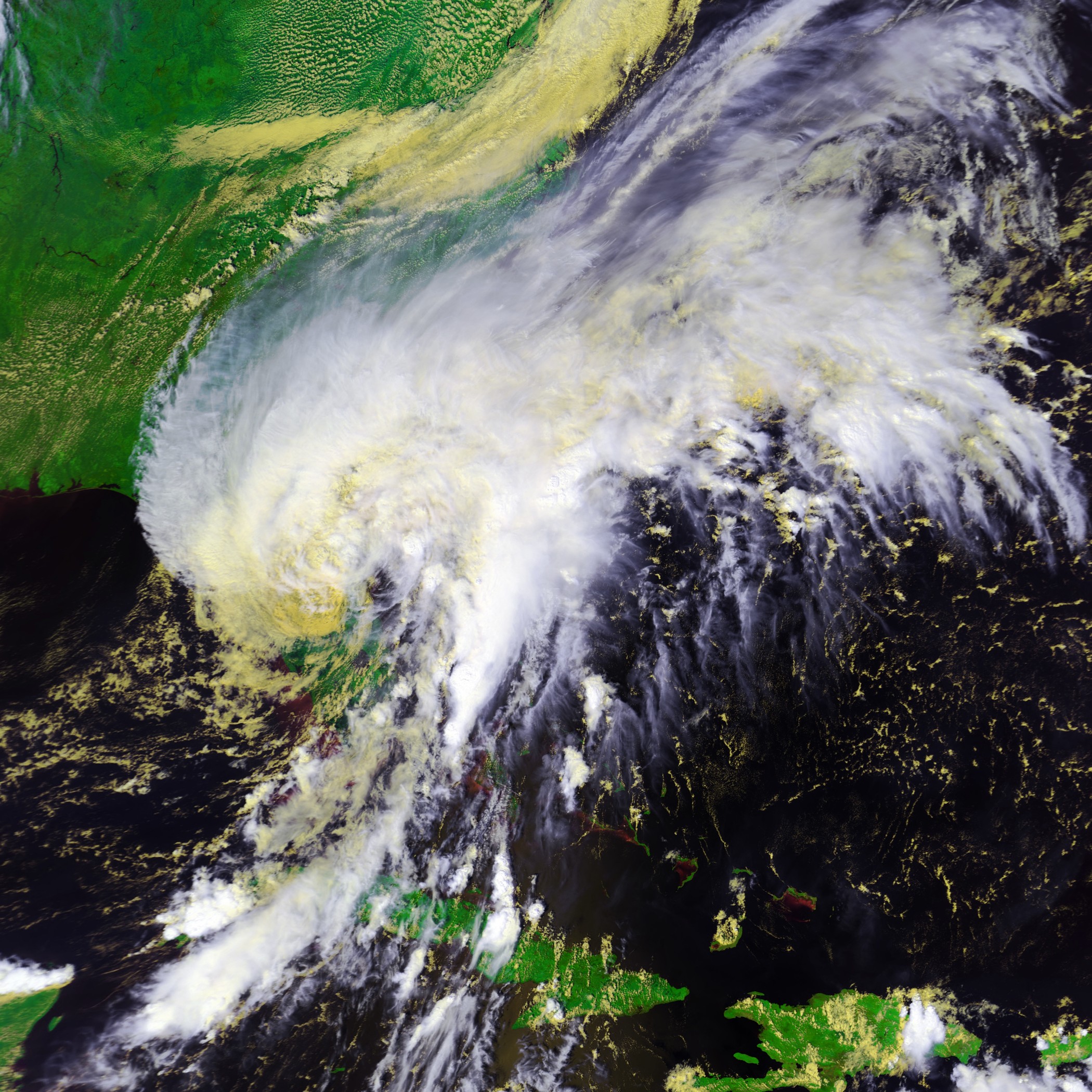
Track=Gabrielle 2001 track.pngSeptember 11
Dissipated=September 19
1-min winds=70
Pressure=975September 11 . After performing a small loop in the gulf, the depression reached tropical storm strength and was designated Gabrielle. Tropical Storm Gabrielle headed northeast and made landfall nearVenice, Florida onSeptember 14 just under hurricane strength. Eighteen hours later, Gabrielle moved offshore, still a tropical storm. It continued northeast, and strengthened to a minimal hurricane. OnSeptember 19 , while south of Newfoundland, Gabrielle was designated an extratropical storm. By the 21st, it had merged with another low.cite web|author=Miles Lawrence and Eric Blake|year=2001|title=Hurricane Gabrielle Tropical Cyclone Report|publisher=National Hurricane Center|accessdate=2008-09-21|url=http://www.nhc.noaa.gov/2001gabrielle.html]Gabrielle dropped torrential rainfall across Florida, amounting to a maximum of convert|13|in|mm in Pierson. The storm caused one drowning deaths and one indirect death in Florida, and damage totaled to about $230 million (2001 USD). Over six inches (152 mm) of rain were reported in parts of Newfoundland, with one station reporting a rainfall rate of nearly 2 inches/hour.
Tropical Depression Nine
Infobox Hurricane Small
Basin=Atl.jpg)
Track=9-L 2001 track.pngSeptember 19
Dissipated=September 20
1-min winds=30
Pressure=1005September 19 , about 60 (95 km) North-Northwest of theSan Andres Island . It attained a maximum strength of convert|35|mi/h|km/h|abbr=on, with a minimum pressure of 1005 mbar.When it first formed, it was never forecast to become a tropical storm, but as a result of forming so close to land, it made landfall nearPuerto Cabezas onSeptember 20 . It dropped a large amount of rain, and brought mild winds to Central America, especially aroundPuerto Cabezas . After losing its closed circulation over land, it reformed into Hurricane Juliette in the East Pacific.Hurricane Humberto
Infobox Hurricane Small
Basin=Atl
Track=Humberto 2001 track.pngSeptember 21
Dissipated=September 27
1-min winds=90
Pressure=970September 21 while convert|425|nmi|km|abbr=on south of Bermuda. The low tracked northwest and was named Tropical Storm Humberto the next day. It began moving north, and then northeast as it passed Bermuda and strengthened into a hurricane. Humberto headed over the colder waters of the far north Atlantic Ocean, and dissipated quickly onSeptember 27 . There were no reports of damage related to Humberto.Hurricane Iris
Infobox Hurricane Small
Basin=Atl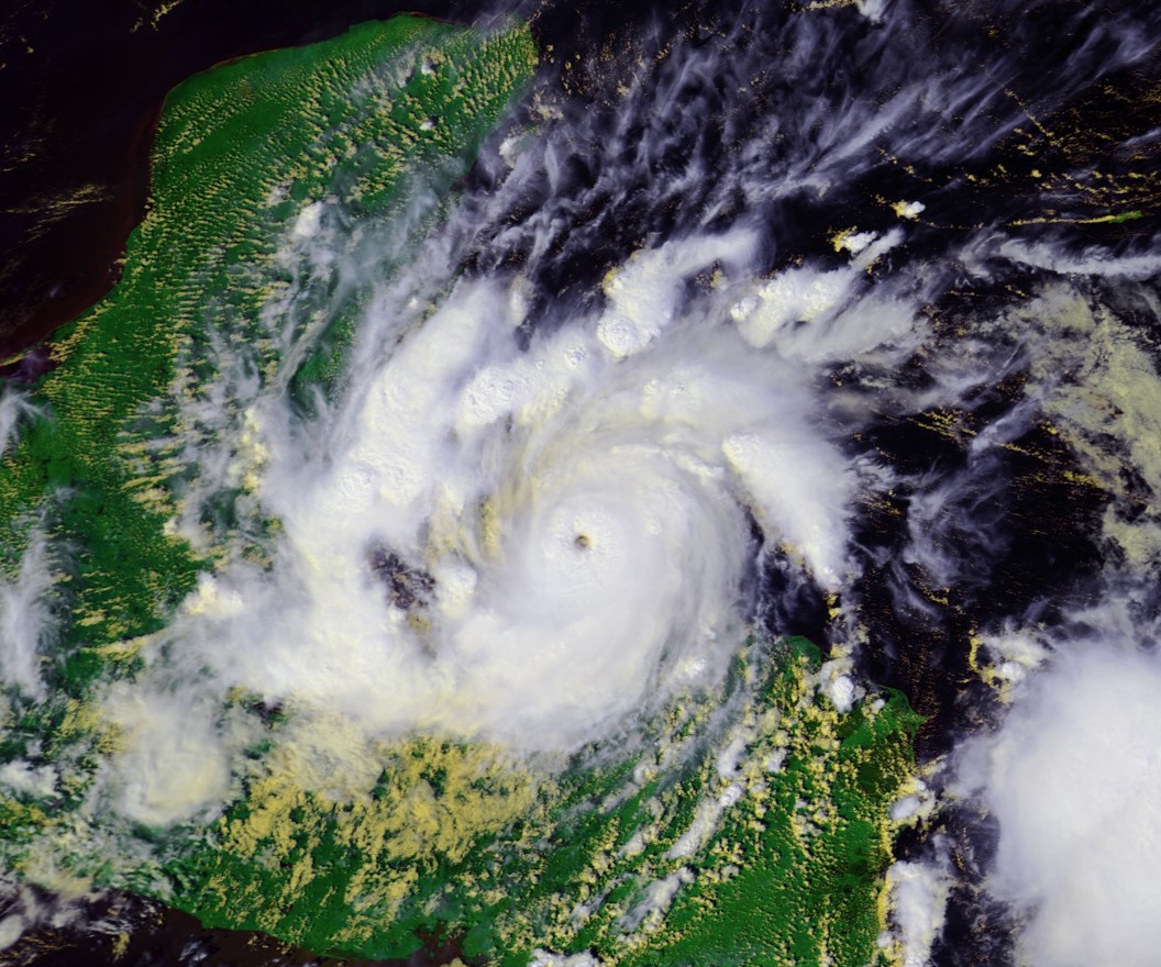
Track=Iris 2001 track.pngOctober 4
Dissipated=October 9
1-min winds=125
Pressure=948October 4 . It traveled across the Windward Islands, and was named Tropical Storm Iris while south ofPuerto Rico on the 5th. Iris continued to the west and intensified. After passing just south of Jamaica, Iris reached Category 4 hurricane strength. Iris made landfall nearMonkey River Town ,Belize onOctober 9 at Category 4 strength, but weakened rapidly. It dissipated later that day.An exact death toll is unknown, but 31 are confirmed dead, 3 in the
Dominican Republic , 8 inGuatemala , and 20 from the M/V "Wave Dancer", a ship that capsized off the Belize coast. Newspapers have reported an additional 30 deaths in Belize, but the government there has only confirm the 20 deaths from the "Wave Dancer". Damage in Belize is reported at $66.2 million.Tropical Storm Jerry
Infobox Hurricane Small
Basin=Atl
Track=Jerry 2001 track.pngOctober 6
Dissipated=October 8
1-min winds=45
Pressure=1004October 6 about convert|620|mi|km east-southeast ofBarbados . Under weak vertical shear and with warm water temperatures, it strengthened into a tropical storm on the 7th, and reached a peak of convert|50|mi/h|km/h|abbr=on later that day. Jerry passed just south ofBarbados on the 7th and 8th, where upper level shear disrupted the circulation, making it elongated and weaker. Just 6 hours before dissipating, Jerry was still forecast to become a hurricane, but its rapid westward movement caused it to dissipate onOctober 8 in the Caribbean Sea convert|230|mi|km south ofPuerto Rico . There were no reports of damage.Hurricane Karen
Infobox Hurricane Small
Basin=Atl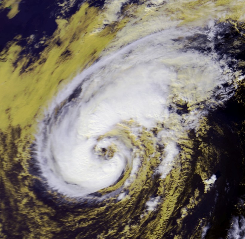
Track=Karen 2001 track.pngOctober 12
Dissipated=October 15
1-min winds=70
Pressure=982October 12 , an extratropical low just south of Bermuda was classified as Subtropical Storm One. After passing Bermuda, the storm took on enough tropical characteristics to be reclassified as Tropical Storm Karen. Karen continued north, strengthening into a hurricane, but slowly weakened and made landfall onNova Scotia onOctober 15 as a tropical storm. Its remnants were absorbed by a larger system later that day.Karen was responsible for sinking several small ships in St. George Harbor, and caused $1.4 million in damage (2001 USD) in
Bermuda . Nova Scotia andNew Brunswick benefited from the storm, as it dropped light rainfall that helped relieve a drought in the area.Tropical Storm Lorenzo
Infobox Hurricane Small
Basin=Atl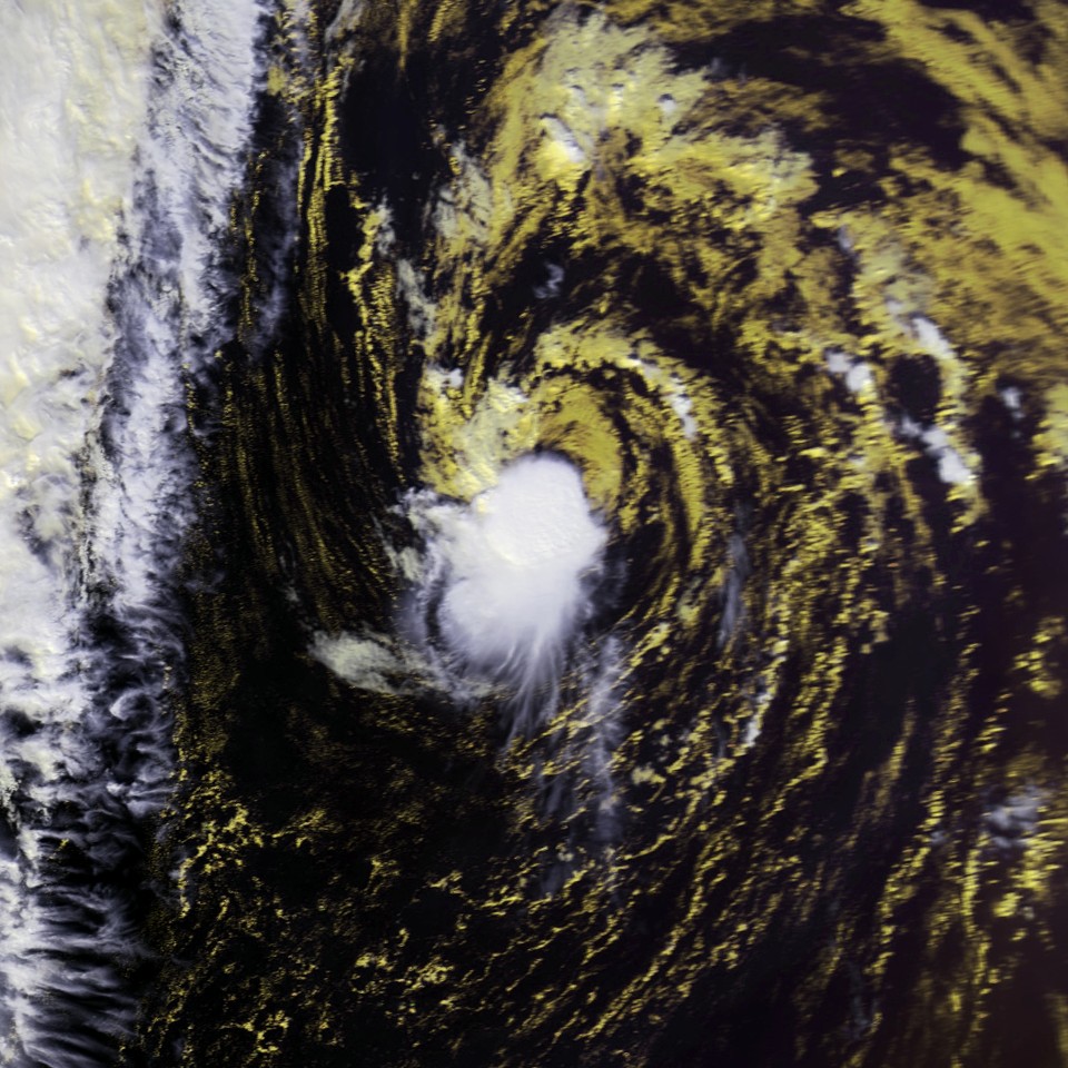
Track=Lorenzo 2001 track.pngOctober 27
Dissipated=October 31
1-min winds=35
Pressure=1007Atlantic Ocean , developing a low-level circulation byOctober 26 which quickly gained organization.cite web | author = Miles B. Lawrence| publisher = National Hurricane Center | title = Tropical Cyclone Report - Tropical Storm Lorenzo | date =December 6 ,2001 | accessdate=2008-01-07 | url = http://www.nhc.noaa.gov/2001lorenzo.html] OnOctober 27 , the low developed into Tropical Depression Fourteen about 860 miles (1380 kilometers) south-southwest of the westernAzores .cite web | author = Jack Beven| publisher = National Hurricane Center | title = Tropical Depression 14 - Discussion Number 3 | date =October 27 ,2001 | accessdate=2008-01-07 | url = http://www.nhc.noaa.gov/archive/2001/dis/al142001.discus.001.html] The depression was forecast to attain winds of at least 60 mph (95 km/h), although it failed to reach that intensity.cite web | author = Jack Beven | publisher = National Hurricane Center | title = Tropical Storm Lorenzo - Discussion Number 11 | date =October 30 ,2001 | accessdate=2008-01-07 | url = http://www.nhc.noaa.gov/archive/2001/dis/al142001.discus.011.html] cite web | author = Stacy Stewart | publisher = National Hurricane Center | title = Tropical Depression 14 - Discussion Number 5 | date =October 28 ,2001 | accessdate=2008-01-08 | url = http://www.nhc.noaa.gov/archive/2001/dis/al142001.discus.005.html] Banding features developed over the storm, and onOctober 30 it was upgraded to Tropical Storm Lorenzo. By early onOctober 31 , convection had begun to separate from the circulation,cite web | author = Jack Beven | publisher = National Hurricane Center | title = Tropical Storm Lorenzo - Discussion Number 13 | date =October 30 ,2001 | accessdate=2008-01-08 | url = http://www.nhc.noaa.gov/archive/2001/dis/al142001.discus.013.html] cite web | author = Jack Beven | publisher = National Hurricane Center | title = Tropical Storm Lorenzo - Discussion Number 14 | date =October 30 ,2001 | accessdate=2008-01-07 | url = http://www.nhc.noaa.gov/archive/2001/dis/al142001.discus.014.html] and later in the day Lorenzo became extratropical; shortly thereafter, its remnants merged with a frontal system about 690 miles (1110 km) west of theAzores .cite web | author = Miles B. Lawrence| publisher = National Hurricane Center | title = Tropical Cyclone Report - Tropical Storm Lorenzo | date =December 6 ,2001 | accessdate=2008-01-07 | url = http://www.nhc.noaa.gov/2001lorenzo.html] cite web | author = Richard J. Pasch| publisher = National Hurricane Center | title = Tropical Storm Lorenzo - Discussion Number 16 | date =October 31 ,2001 | accessdate=2008-01-08 | url = http://www.nhc.noaa.gov/archive/2001/dis/al142001.discus.016.html] One ship reported winds of 42–49 mph (49–78 km/h) onOctober 28 andOctober 29 , as it neared then Tropical Depression Fourteen.Hurricane Michelle
Infobox Hurricane Small
Basin=Atl
Track=Michelle 2001 track.pngOctober 29
Dissipated=November 5
1-min winds=120
Pressure=933November 1 nearCabo Gracias ,Nicaragua . It headed north and quickly strengthened, reaching Category 4 intensity byNovember 4 . Michelle made landfall near theBay of Pigs shortly afterward. Weakened, but still a hurricane, Michelle continued on through the Bahamas, where it degenerated and was absorbed by a front onNovember 6 .Michelle is officially responsible for 17 deaths, and 26 missing. Damage amounted to over $1.8 billion (2001 USD). [http://www.aoml.noaa.gov/hrd/Landsea/NHR-Cuba.pdf Hurricane Vulnerability in Latin America and the Caribbean] ]
Hurricane Noel
Infobox Hurricane Small
Basin=Atl
Track=Noel 2001 track.pngNovember 4
Dissipated=November 6
1-min winds=65
Pressure=986November 2 . It moved westward and deepened, organizing into a subtropical storm onNovember 4 while well east ofBermuda . As it moved northward, convection organized into a ring near the center, and was classified as Hurricane Noel on the 5th, based on a ship report of convert|75|mi/h|km/h|abbr=on winds near the center. Westerly shear quickly weakened the hurricane, and onNovember 6 Noel became extratropical. The extratropical storm continued northward, and was absorbed by a larger system. Noel caused no reported damage.Hurricane Olga
Infobox Hurricane Small
Basin=Atl
Track=Olga 2001 track.pngNovember 24
Dissipated=December 6
1-min winds=80
Pressure=973November 24 . Initially a subtropical storm, Olga began taking on tropical characteristics and started on a winding southwestward track. Olga strengthened into a hurricane, but by early December had weakened, and dissipated byDecember 5 . The only damage report came from a single yacht, which passed through Olga's center on the 24th.cite web|author=Lixion A. Avila|year=2001|title=NHC Report on Olga|publisher=National Hurricane Center|accessdate=2008-09-21|url=http://www.nhc.noaa.gov/2001olga.html]eason impact
TC stats cyclone|cat=storm|name=Allison|dates=4 - 18 June
max-winds=60 |min-press=1000|ace= 0.61|mult-landfalls=2TC stats cyclone|cat=depression|name=Two|dates=11 - 12 July
max-winds=35|min-press=1010|ace= 0TC stats cyclone|cat=storm|name=Barry|dates=2 -8 August
max-winds=70|min-press=990|ace= 2.47TC stats cyclone|cat=storm|name=Chantal
dates=14 - 21 August|max-winds=70|min-press=997|ace= 4.62TC stats cyclone|cat=storm|name=Dean|dates=22 - 28 Aug
max-winds=70|min-press=994|ace= 2.94TC stats cyclone|cat=cat3|name=Erin|dates=1 - 15 Sept
max-winds=120|min-press=968|ace=20.12|TC stats cyclone|cat=cat3|name=Felix|dates=7 - 19 Sept
max-winds=115|min-press=962|ace= 15.22TC stats cyclone|cat=cat1|name=Gabrielle|dates=11 - 19 Sept
max-winds=80|min-press=975|ace= 6.60TC stats cyclone|cat=depression|name=Nine|dates=19 - 20 September
max-winds=35|min-press=1005|ace= 0TC stats cyclone|cat=cat2|name=Humberto|dates=21 - 27 Sept
max-winds=105|min-press=970|ace= 9.94TC stats cyclone|cat=cat4|name=Iris|dates=4 - 9 Oct
max-winds=145|min-press=948|ace= 9.99TC stats cyclone|cat=storm|name=Jerry|dates=6 - 8 Oct
max-winds=50|min-press=1004|ace= 1.22TC stats cyclone|cat=cat1|name=Olga|dates=24 Nov - 4 Dec
max-winds=90|min-press=973|ace=10.64TC stats table end|num-cyclones-text=17 cyclones|dates=June 5
-December 4 |max-winds=145|min-press=933|tot-ace=105.6|num-landfalls=11|tot-da
7900
tot-deaths=93 (24)See also
*
List of Atlantic hurricane seasons
*List of tropical cyclones
*2001 Pacific hurricane season
*2001 Pacific typhoon season
*2001 North Indian Ocean cyclone season
*South-West Indian Ocean cyclone seasons: 2000–01, 2001–02
*Australian region cyclone seasons: 2000–01, 2001–02
*South Pacific cyclone seasons: 2000–01, 2001–02References
External links
* [http://www.aoml.noaa.gov/general/lib/lib1/nhclib/mwreviews/2001.pdf Monthly Weather Review]
* [http://www.nhc.noaa.gov/2001.html National Hurricane Center 2001 Atlantic hurricane season summary]
* [http://www.hpc.ncep.noaa.gov/tropical/rain/2001.html U. S. Rainfall from Tropical Cyclones in 2001]
* [http://hurricanehut.tripod.com The Hurricane Hut] - Detailed and Comprehensive Information on All the Storms of the 2001 Season
Wikimedia Foundation. 2010.