- 2005 Pacific hurricane season
Infobox hurricane season
Basin=EPac
Year=2005
Track=2005 Pacific hurricane season map.pngMay 17 ,2005
Last storm dissipated=October 20 ,2005
Strongest storm name=Kenneth
Strongest storm pressure=947
Strongest storm winds=115
Average wind speed=1
Total depressions=17
Total storms=15
Total hurricanes=7
Total intense=2
Fatalities=4+
Da
Inflated=
five seasons=2003, 2004, 2005, 2006, 2007May 15 ,2005 in the eastern Pacific and onJune 1 2005 in the central Pacific, and lasted untilNovember 30 ,2005 . These dates conventionally delimit the period of each year when mosttropical cyclones form in the northeastern Pacific Ocean. The season got off to a quick start, with the tropical depression that would become Hurricane Adrian forming just two days into the season onMay 17 . It took a very rare track skirtingEl Salvador as a Category 1 hurricane then strikingHonduras as atropical depression . Between June and September, Dora was the only storm that posed a significant threat to land as it skirted the Mexican coast, and Kenneth came close toHawaii as a dissipating tropical depression. Hurricane Otis appeared to be heading for an encounter with theBaja California peninsula , but turned north-northwest, paralleling the coast, before dissipating.__TOC__Pre-season forecasts
The U.S.
National Oceanic and Atmospheric Administration predicted a slow year, with only a 10% chance of above-average storm activity in the eastern North Pacific and a 70% chance of below-normal activity. The pre-season forecast predicted 11 to 15 tropical storms, 6 to 8 hurricanes, and 2 to 4 major hurricanes (Category 3 or higher on the Saffir-Simpson Hurricane Scale).cite web| author=Climate Prediction Center, NOAA| year=2005-05-16 | title= NOAA Releases East Pacific Hurricane Season Outlook: Below Normal Seasonal Activity Expected in 2005| publisher=National Oceanic and Atmospheric Administration| accessdate=2006-08-18|url=http://www.publicaffairs.noaa.gov/releases2005/may05/noaa05-061.html]The forecast for the central North Pacific was for a below-average season, with only two or three storms impacting the region, below the normal four to five.cite web| author=Climate Prediction Center, NOAA| year=
2005-05-16 | title= NOAA Expects Below Average Central Pacific Hurricane Season: Hawaii Observes Hurricane Preparedness Week May 15-21| publisher=National Oceanic and Atmospheric Administration| accessdate=2006-08-18|url=http://www.publicaffairs.noaa.gov/releases2005/may05/noaa05-058.html]torms
Hurricane Adrian
Infobox Hurricane Small
Basin=EPac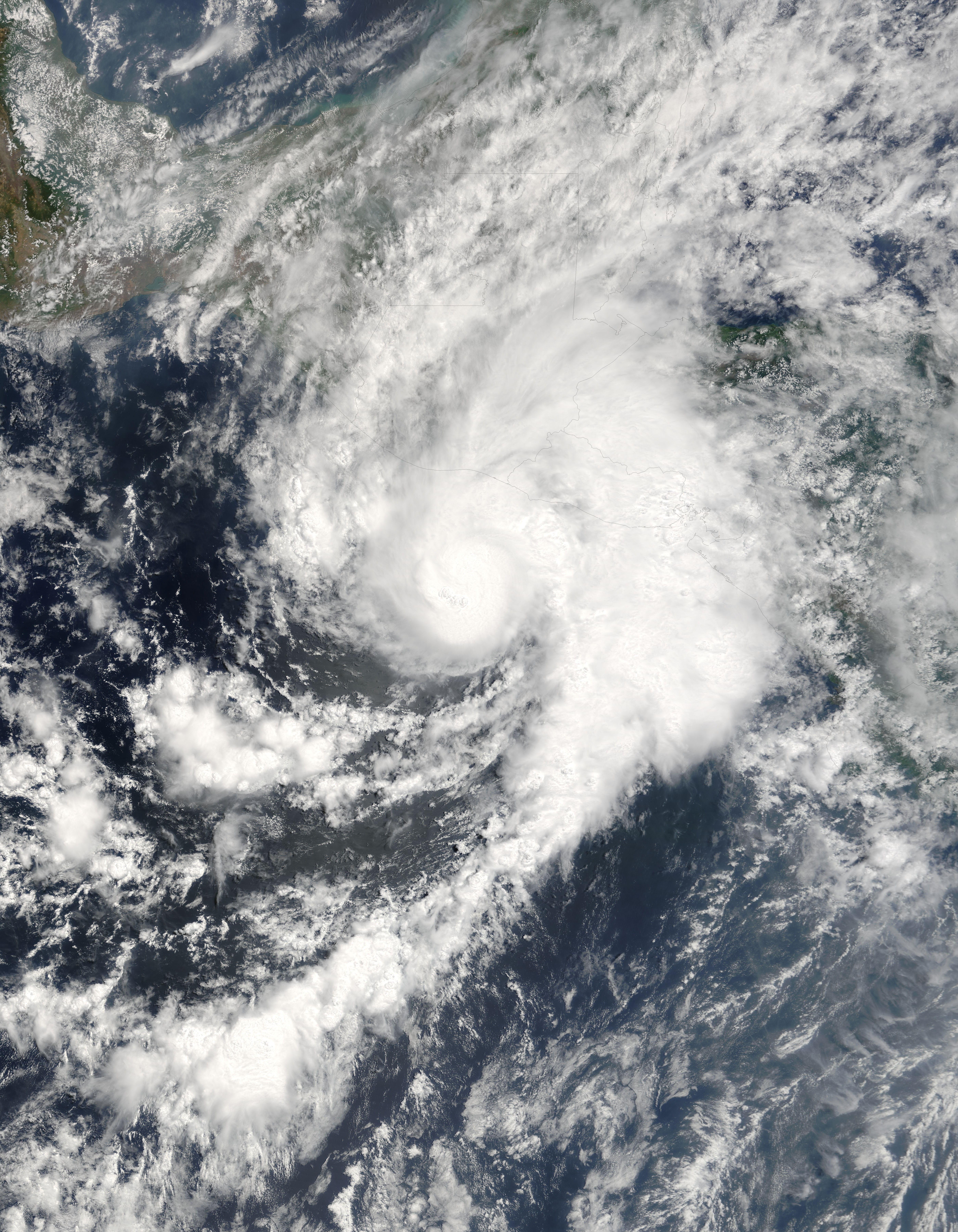
Track=Adrian 2005 track.pngMay 17
Dissipated=May 21
1-min winds=70
Pressure=982May 17 , only two days after the season began. It strengthened from a tropical depression about 440 miles (710 km) southwest ofGuatemala andEl Salvador and began tracking northeast towardsSan Salvador , and reached hurricane strength on the morning ofMay 19 . It turned east and made landfall inHonduras in theGulf of Fonseca late onMay 19 , after weakening offshore to tropical depression strength. It weakened rapidly once onshore, dissipating over the mountains of Honduras. Three indirect deaths are linked to the storm, but according to the NHC's May Summary, releasedJune 1 , no direct deaths had been reported. Damage figures are not yet available. [ [http://www.nhc.noaa.gov/archive/2005/tws/MIATWSEP_may.shtml Tropical Weather Summary ] ]The north-easterly track of this storm was extremely unusual. Only four tropical systems had been recorded to have made landfall in Guatemala or El Salvador since 1966. The only named system ever to do so was Tropical Storm Andres on
June 7 ,1997 , nearSan Salvador as a tropical depression. The storm was also somewhat rare in how early it was; hurricanes form in May only once about every four years.
* The NHC's [http://www.nhc.noaa.gov/archive/2005/ADRIAN.shtml archive on Hurricane Adrian] .
* The NHC's [http://www.nhc.noaa.gov/pdf/TCR-EP012005_Adrian.pdf Tropical Cyclone Report on Hurricane Adrian] .Tropical Storm Beatriz
Infobox Hurricane Small
Basin=EPac
Track=Beatriz 2005 track.pngJune 21
Dissipated=June 24
1-min winds=45
Pressure=1000Zihuatanejo ,Guerrero , onJune 21 , reaching tropical storm strength the next day, with windspeeds peaking at around 50 mph (80 km/h) onJune 23 . It slowly moved west and dissipated into a remnant low on the morning ofJune 24 about 290 miles (470 km) fromCabo San Lucas on the southern tip of theBaja California Peninsula , having never threatened land.
* The NHC's [http://www.nhc.noaa.gov/archive/2005/BEATRIZ.shtml archive on Tropical Storm Beatriz] .
* The NHC's [http://www.nhc.noaa.gov/pdf/TCR-EP022005_Beatriz.pdf Tropical Cyclone Report on Tropical Storm Beatriz] .Tropical Storm Calvin
Infobox Hurricane Small
Basin=EPac
Track=Calvin 2005 track.pngJune 26
Dissipated=June 29
1-min winds=45
Pressure=1000Mexico early onJune 26 , and reached tropical storm strength and was named Calvin late that day. Tropical storm watches were issued for the southern coast of Mexico aroundAcapulco as Calvin slowly moved westward, with windspeeds peaking at 50 mph (80 km/h) onJune 27 , but all watches were cancelled on the morning ofJune 28 as it moved away from the coast. Calvin weakened to a tropical depression later that day, and lost tropical characteristics that night.
* The NHC's [http://www.nhc.noaa.gov/archive/2005/CALVIN.shtml archive on Tropical Storm Calvin] .
* The NHC's [http://www.nhc.noaa.gov/pdf/TCR-EP032005_Calvin.pdf Tropical Cyclone Report on Tropical Storm Calvin] .Tropical Storm Dora
Infobox Hurricane Small
Basin=EPac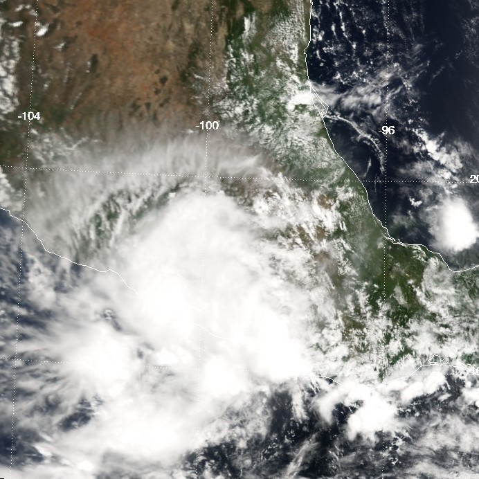
Track=Dora 2005 track.pngJuly 4
Dissipated=July 6
1-min winds=40
Pressure=1003July 3 from a tropical wave south of the Mexican port ofAcapulco ,Guerrero . Watches and warnings were issued as it neared the Mexican coast. On the afternoon ofJuly 4 , the depression strengthened into a tropical storm while located about 45 miles (75 km) west-southwest of Acapulco. It came within miles of the coast, moving somewhat parallel to it onJuly 4 , dropping heavy rainfall on the region. As it moved away from the coast, all watches were cancelled as it dropped to a tropical depression midday onJuly 5 , finally dissipating early onJuly 6 .
* The NHC's [http://www.nhc.noaa.gov/archive/2005/DORA.shtml archive on Tropical Storm Dora] .
* The NHC's [http://www.nhc.noaa.gov/pdf/TCR-EP042005_Dora.pdf Tropical Cyclone Report on Tropical Storm Dora] .Tropical Storm Eugene
Infobox Hurricane Small
Basin=EPac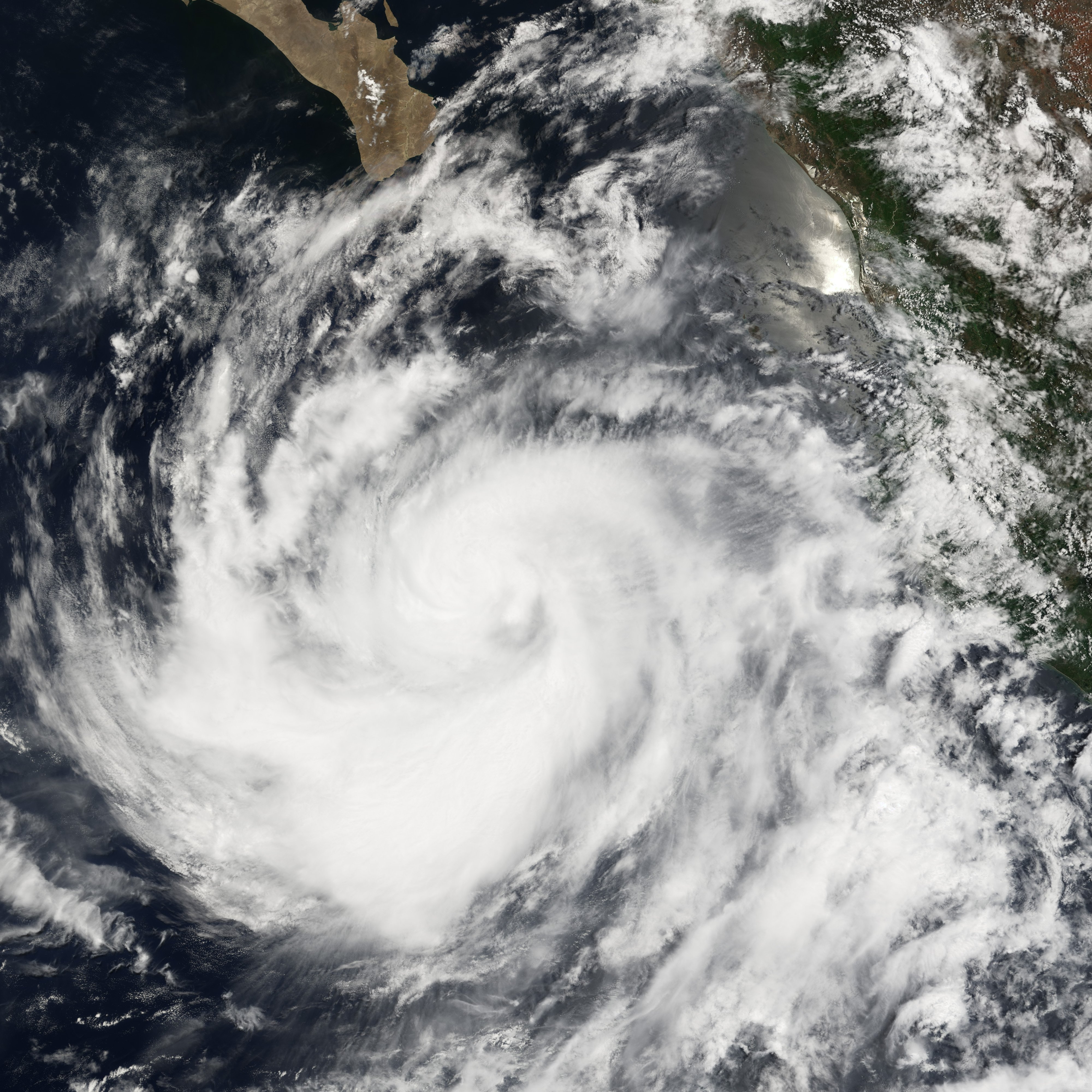
Track=Eugene 2005 track.pngJuly 18
Dissipated=July 20
1-min winds=60
Pressure=989July 18 and headed northwest, one of the few cyclones to reach tropical storm-strength without being designated as a tropical depression. Initially, as with most Eastern Pacific storms, no public advisories or warnings were issued, since it was heading out to sea. However, onJuly 19 it came within range of the southern tip of theBaja California peninsula . Tropical storm watches were issued for the area aroundCabo San Lucas for most of the day, but the storm moved away without affecting land.
* The NHC's [http://www.nhc.noaa.gov/archive/2005/EUGENE.shtml archive on Tropical Storm Eugene] .
* The NHC's [http://www.nhc.noaa.gov/pdf/TCR-EP052005_Eugene.pdf Tropical Cyclone Report on Tropical Storm Eugene] .Tropical Depression One-C
Infobox Hurricane Small
Basin=EPac
Track=1-C 2005 track.pngAugust 3
Dissipated=August 4
1-min winds=25
Pressure=1008Hawaii onAugust 3 , a month later than the first (and only) central system to develop in 2004. It began a track due west, which could have put it within range of the island ofOahu, Hawaii , a few days later. It was initially forecast to strengthen into a tropical storm (one had not formed in the central Pacific since Huko in the 2002 season). However, the next day's models changed to indicate no further increase in strength. Shortly after that, convection bursts ceased and the system lost its closed circulation while still 725 miles (1200 km) from Hilo.
* The CPHC's [http://www.prh.noaa.gov/cphc/summaries/2005.php#td01c summary of Tropical Depression One-C] .Hurricane Fernanda
Infobox Hurricane Small
Basin=EPac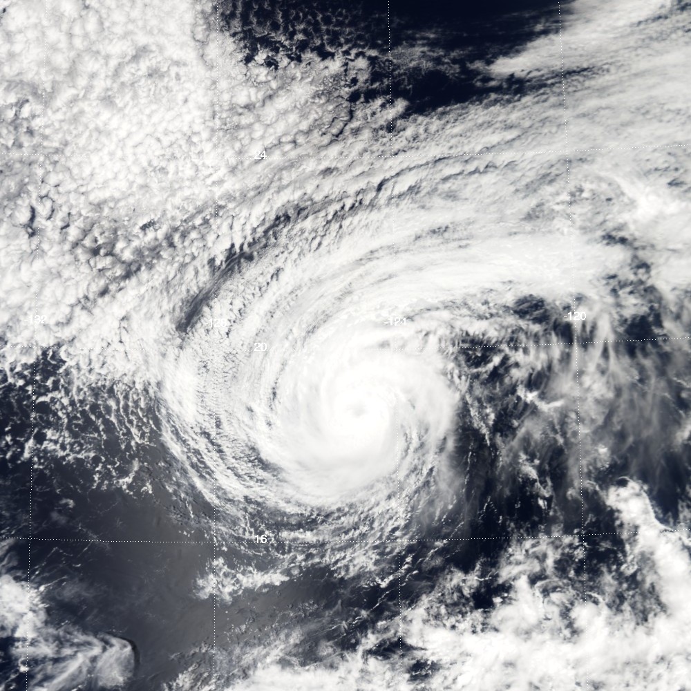
Track=Fernanda 2005 track.pngAugust 9
Dissipated=August 16
1-min winds=75
Pressure=978Cabo San Lucas in theMexican state ofBaja California Sur onAugust 9 . It was upgraded to Tropical Storm Fernanda late that day, and to Hurricane Fernanda onAugust 11 , as it headed generally west-northwest into the openPacific . OnAugust 14 it dropped to tropical storm strength over cooler waters and onAugust 15 weakened to a tropical depression. It degenerated into a remnant low later in the day about convert|1650|mi|km southwest of the southern tip of theBaja California Peninsula .
* The NHC's [http://www.nhc.noaa.gov/archive/2005/FERNANDA.shtml archive on Hurricane Fernanda] .
* The NHC's [http://www.nhc.noaa.gov/pdf/TCR-EP062005_Fernanda.pdf Tropical Cyclone Report on Hurricane Fernanda] .Tropical Storm Greg
Infobox Hurricane Small
Basin=EPac
Track=Greg 2005 track.pngAugust 11
Dissipated=August 15
1-min winds=45
Pressure=1000Cabo San Lucas onAugust 11 , and was upgraded to Tropical Storm Greg a few hours later. Although only 750 miles (1200 km) from Hurricane Fernanda it showed no signs of being pushed northwards by interaction, but set off westwards to follow Fernanda into the Pacific. Greg was downgraded to tropical depression status onAugust 14 and remained stationary throughout the day. It began drifting slowly westward early onAugust 15 and was destroyed by shear later in the day.
* The NHC's [http://www.nhc.noaa.gov/archive/2005/GREG.shtml archive on Tropical Storm Greg] .
* The NHC's [http://www.nhc.noaa.gov/pdf/TCR-EP072005_Greg.pdf Tropical Cyclone Report on Tropical Storm Greg] .Hurricane Hilary
Infobox Hurricane Small
Basin=EPac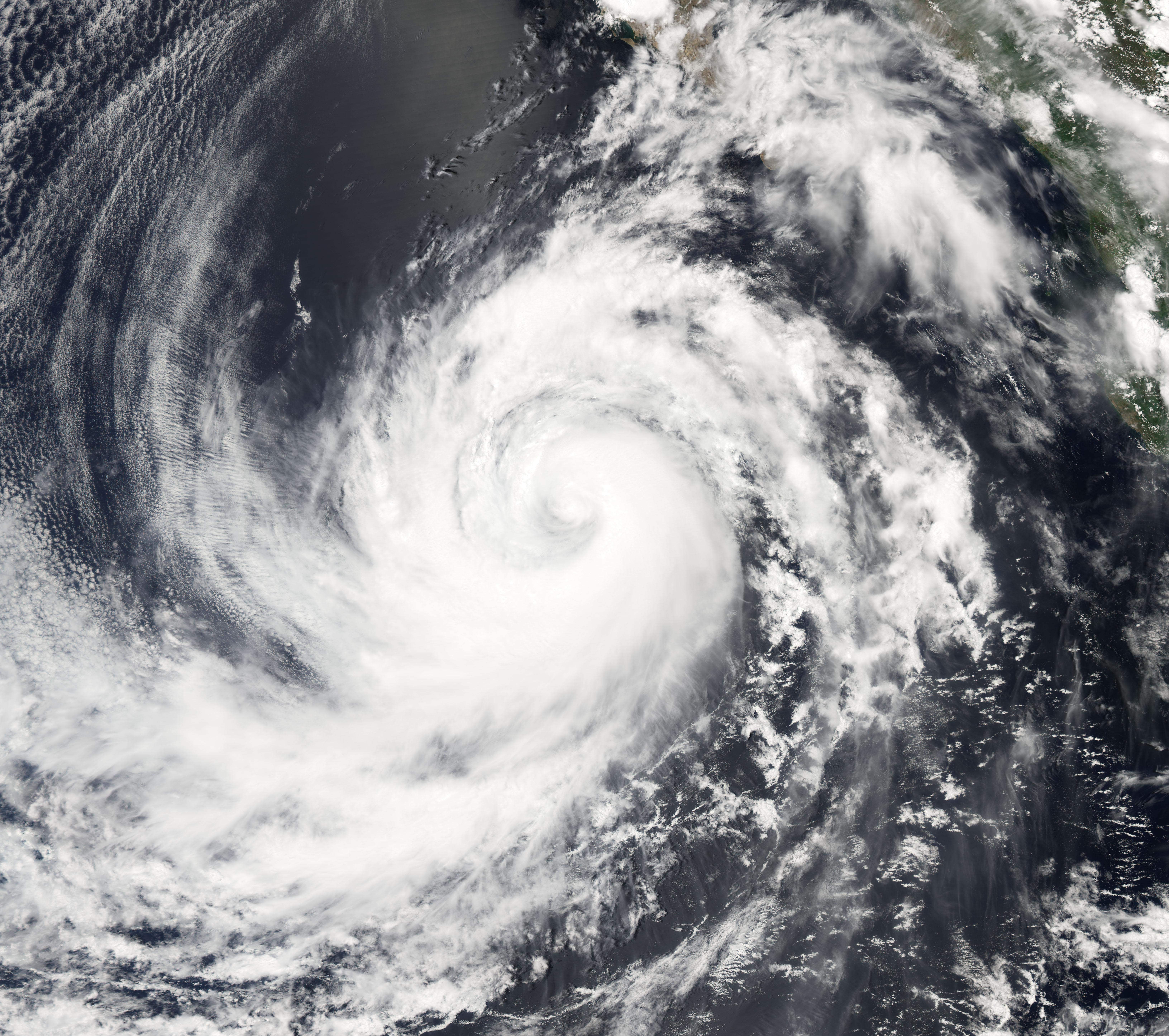
Track=Hilary 2005 track.pngAugust 19
Dissipated=August 25
1-min winds=90
Pressure=970Africa onAugust 4 . The wave initially had a large area of deep convention, but the convention quickly diminished as the system moved across the eastern portion of the tropical Atlantic Ocean. The wave continued westward without much development or organization, and crossed northernSouth America and then entered the northernPacific Ocean onAugust 17 . Mid-level circulation and convention organized with the wave, as it was south ofGuatemala onAugust 18 . The system's organization persisted, but without defining a well-established center of circulation, at the surface.Tropical Depression Eight-E finally formed from the area of disturbed weather south of the Gulf of Tehuantepec, convert|140|mi|km south of Puerto Angel,Mexico , onAugust 19 . It strengthened to a tropical storm late that evening, and reached hurricane strength 24 hours later. Moving parallel to the Mexican coast and about convert|300|mi|km off-shore, it reached Category 2 on theSaffir-Simpson Hurricane Scale late onAugust 21 . Tropical storm winds affected the coast and a tropical storm warning was issued for a while. Hilary dissipated not long after weakening to a tropical storm onAugust 25 .
* The NHC's [http://www.nhc.noaa.gov/archive/2005/HILARY.shtml archive on Hurricane Hilary] .
* The NHC's [http://www.nhc.noaa.gov/pdf/TCR-EP082005_Hilary.pdf Tropical Cyclone Report on Hurricane Hilary] .Tropical Storm Irwin
Infobox Hurricane Small
Basin=EPac
Track=Irwin 2005 track.pngAugust 25
Dissipated=August 28
1-min winds=45
Pressure=1000Colima onAugust 25 , out of a remnant wave that split from Atlantic Tropical Depression Ten (the other part of the wave would eventually develop intoHurricane Katrina ) that crossedCentral America . The depression strengthened to Tropical Storm Irwin early the next day, reaching wind speeds of 50 mph (85 km/h). Although Irwin headed almost due west over warm water, it encountered shear, soon weakened and dissipated onAugust 28 .
* The NHC's [http://www.nhc.noaa.gov/archive/2005/IRWIN.shtml archive on Tropical Storm Irwin] .
* The NHC's [http://www.nhc.noaa.gov/pdf/TCR-EP092005_Irwin.pdf Tropical Cyclone Report on Tropical Storm Irwin] .Hurricane Jova
Infobox Hurricane Small
Basin=EPac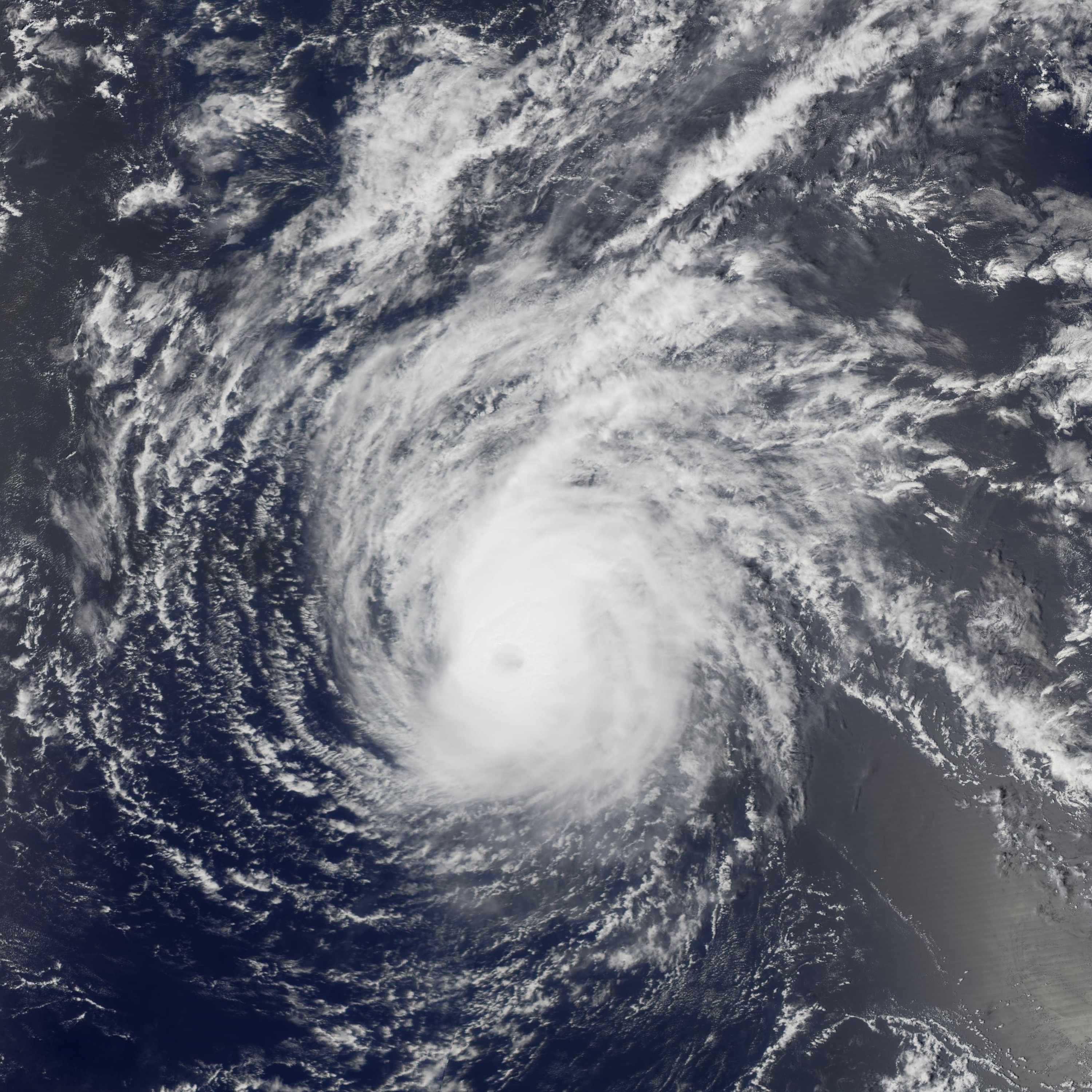
Track=Jova 2005 track.pngSeptember 12
Dissipated=September 25
1-min winds=110
Pressure=951September 11 well south-southwest of theBaja California Peninsula and headed almost due west. Late onSeptember 14 , the depression strengthened and was upgraded to tropical storm status. It strengthened further to hurricane status early onSeptember 16 . OnSeptember 18 it crossed meridian 140°W, becoming the first hurricane in over two years to be in the forecast area of theCentral Pacific Hurricane Center . Jova soon strengthened to a major hurricane, the first one to exist in the Central Pacific since Ele in 2002. It weakened as it steered to the northeast of Hawai‘i, weakening to a tropical storm onSeptember 22 and to a tropical depression onSeptember 23 before finally dissipating onSeptember 24 .
* The NHC's [http://www.nhc.noaa.gov/archive/2005/JOVA.shtml archive on Hurricane Jova] .
* The CPHC's [http://www.prh.noaa.gov/cphc/summaries/2005.php#jova summary of Hurricane Jova] .
* The NHC's [http://www.nhc.noaa.gov/pdf/TCR-EP102005_Jova.pdf Tropical Cyclone Report on Hurricane Jova] .Hurricane Kenneth
Infobox Hurricane Small
Basin=EPac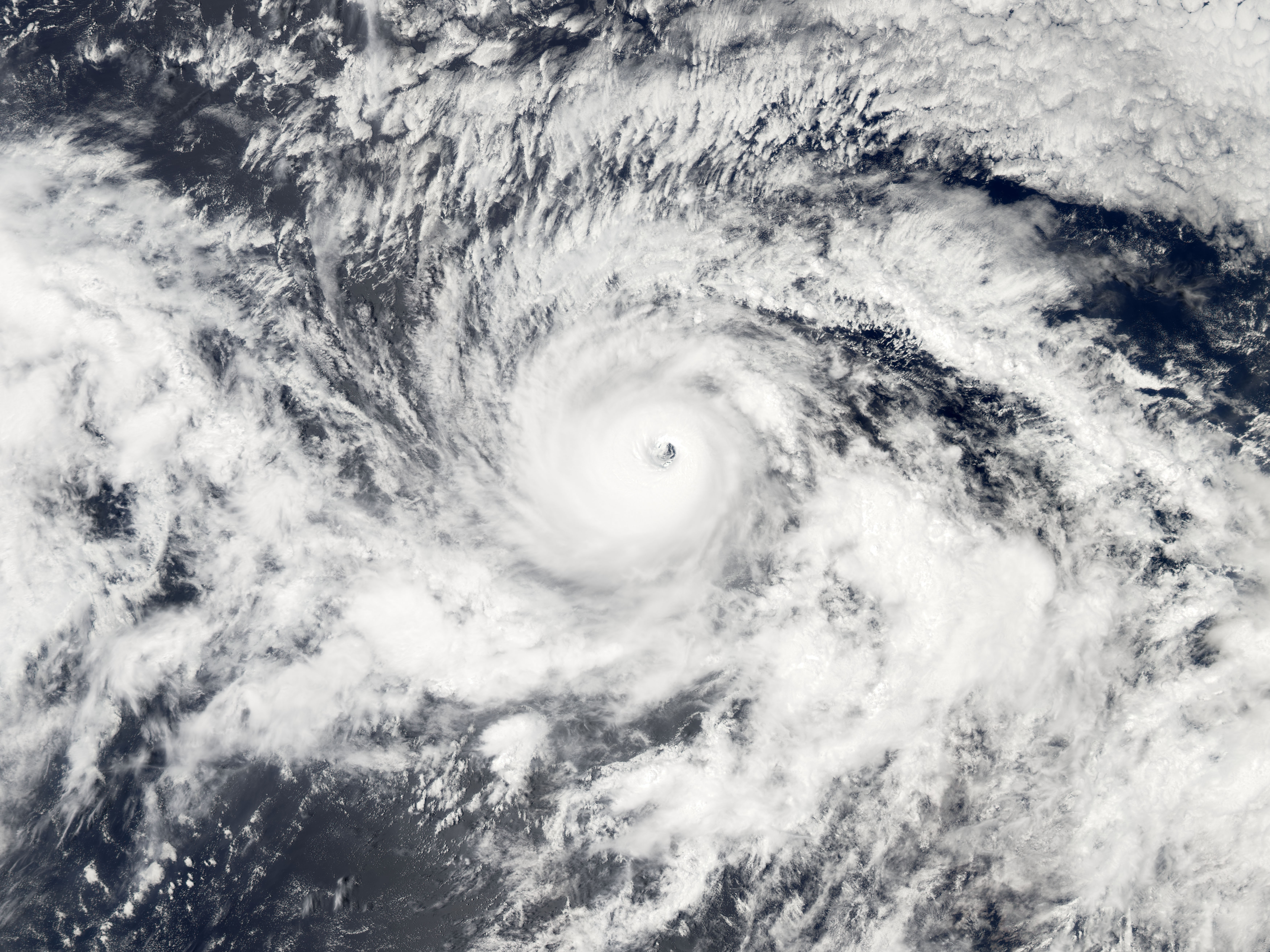
Track=Kenneth 2005 track.pngSeptember 14
Dissipated=September 30
1-min winds=115
Pressure=947September 14 . Again, the depression was well south-southwest of theBaja California Peninsula when it formed just convert|600|mi|km east of Depression Ten-E. It found more favorable conditions than its western neighbor, and was upgraded to Tropical Storm Kenneth just 12 hours after forming. Kenneth strengthened into a hurricane later that day and continued to strengthen very rapidly, becoming the first major hurricane of the season by reaching Category 3 onSeptember 17 . The storm became the strongest storm to form this season in the Eastern Pacific when Kenneth peaked with sustained winds of convert|130|mi/h|km/h|abbr=on, Category 3 on theSaffir Simpson Hurricane Scale . Kenneth began gradually weakening onSeptember 19 , and weakened to a tropical storm onSeptember 20 . However, Kenneth gained enough strength to be reclassified as a Category 1 hurricane onSeptember 24 , and very late onSeptember 25 it crossed 140°W, making it the second hurricane of the season to enter the Central Pacific. It then dropped back again to a tropical storm, and weakened to a tropical depression onSeptember 29 less than convert|400|mi|km east of Hawai‘i. It came within convert|50|mi|km of the Big Island of Hawaii before degenerating into an open wave. No tropical cyclone has made landfall on Hawai‘i since Tropical Depression Eugene in the 1993 season. 6-12 inches of rain was reported on portions of Hawaii.http://www.nhc.noaa.gov/pdf/TCR-EP112005_Kenneth.pdf NHC report on Hurricane Kenneth]
* The NHC's [http://www.nhc.noaa.gov/archive/2005/KENNETH.shtml archive on Hurricane Kenneth] .
* The CPHC's [http://www.prh.noaa.gov/cphc/summaries/2005.php#kenneth summary of Hurricane Kenneth] .
* The NHC's [http://www.nhc.noaa.gov/pdf/TCR-EP112005_Kenneth.pdf Tropical Cyclone Report on Hurricane Kenneth] .Tropical Storm Lidia
Infobox Hurricane Small
Basin=EPac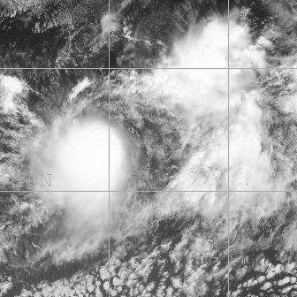
Track=Lidia 2005 track.pngSeptember 17
Dissipated=September 19
1-min winds=35
Pressure=1005Africa n coast at the end of August showed some hints of development while crossing theAtlantic but never developed a tropical circulation there. After crossing theIsthmus of Tehuantepec into the Pacific it acquired better organisation, and became Tropical Depression Twelve-E onSeptember 17 . It was the third depression in quick succession to form well SSW of theBaja California Peninsula , and did so less than convert|800|mi|km east of Hurricane Kenneth. It strengthened to Tropical Storm Lidia later the same day, but the next day was pushed off its course and weakened by the new and larger Tropical Depression Thirteen-E, which became Tropical Storm Max. OnSeptember 18 , Lidia was completely absorbed by the circulation of Max.
* The NHC's [http://www.nhc.noaa.gov/archive/2005/LIDIA.shtml archive on Tropical Storm Lidia] .
* The NHC's [http://www.nhc.noaa.gov/pdf/TCR-EP122005_Lidia.pdf Tropical Cyclone Report on Tropical Storm Lidia] .Hurricane Max
Infobox Hurricane Small
Basin=EPac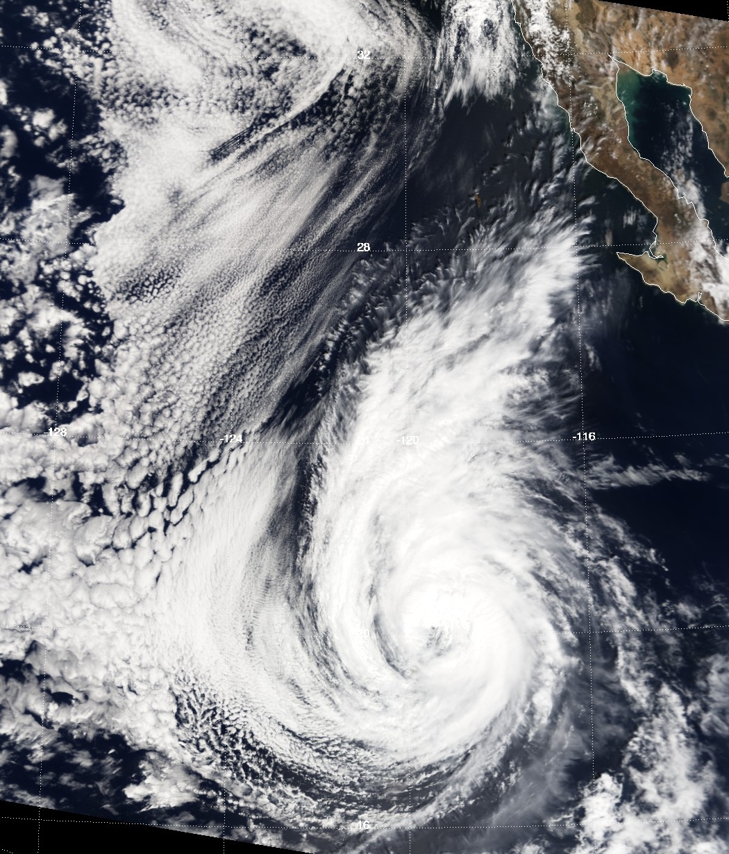
Track=Max 2005 track.pngSeptember 18
Dissipated=September 22
1-min winds=75
Pressure=981Baja California Peninsula onSeptember 18 . It was sufficiently close to Lidia that it blew the earlier, weaker storm rapidly to the north. It strengthened to Tropical Storm Max within a few hours, and absorbed the remnants of Tropical Depression Lidia. On lateSeptember 19 the tropical storm was upgraded to Hurricane Max. The system began to weaken almost immediately thereafter, however, and Max dissipated in the early morning hours ofSeptember 22 .The merger of two tropical cyclones or the absorption of one tropical cyclone by another are uncommon events in the National Hurricane Center's area of responsibility. The last documented case of such an occurrence in the eastern North Pacific was when Hurricane Gil absorbed Tropical Storm Henriette in September 2001.
* The NHC's [http://www.nhc.noaa.gov/archive/2005/MAX.shtml archive on Hurricane Max] .
* The NHC's [http://www.nhc.noaa.gov/pdf/TCR-EP132005_Max.pdf Tropical Cyclone Report on Hurricane Max] .Tropical Storm Norma
Infobox Hurricane Small
Basin=EPac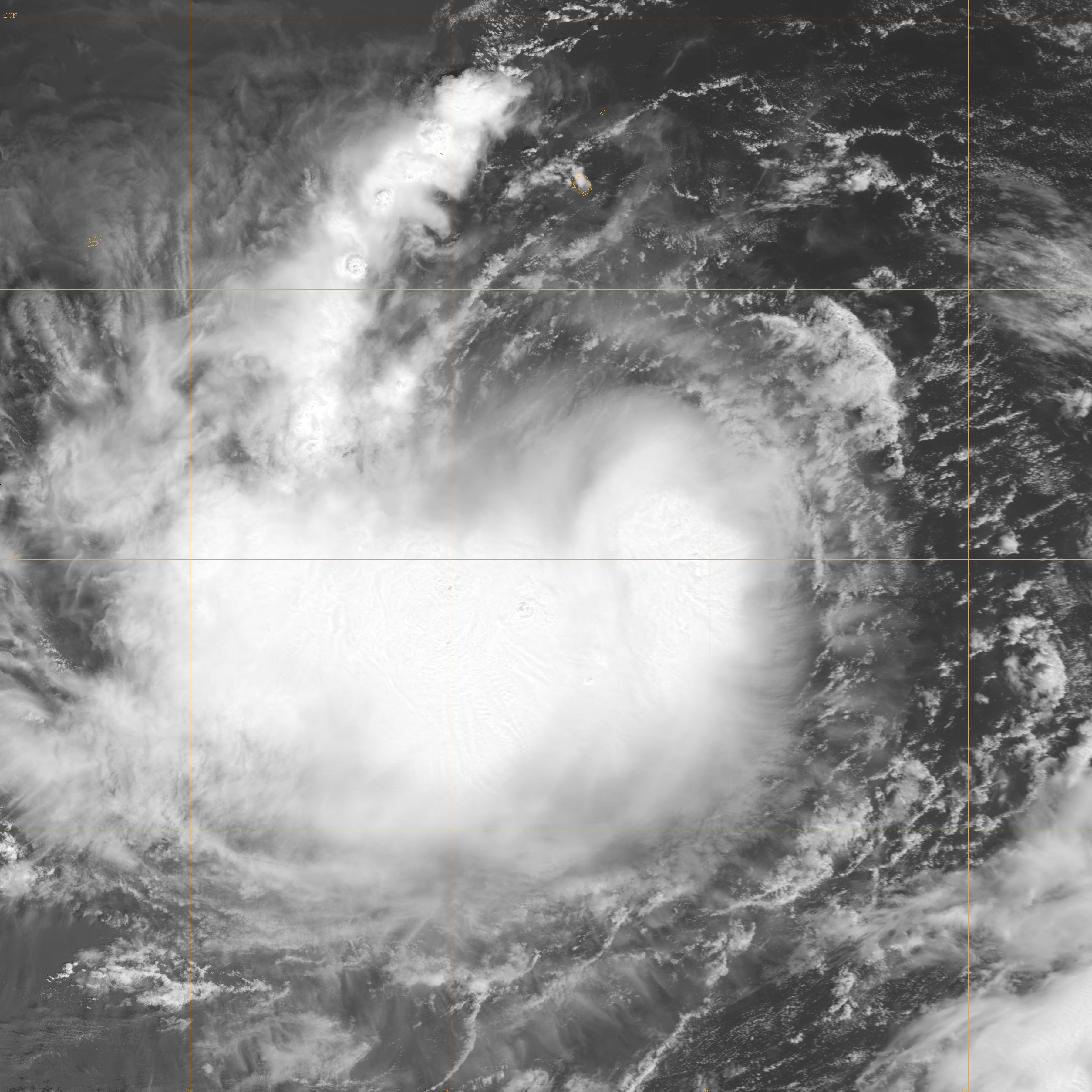
Track=Norma 2005 track.pngSeptember 23
Dissipated=September 27
1-min winds=50
Pressure=997Colima , onSeptember 22 , barely twenty-four hours after theJoint Typhoon Warning Center had initiated a warning noting that "formation of a tropical cyclone is possible." Four hours later Tropical Depression Fourteen-E had strengthened into Tropical Storm Norma. It was never a threat to land, and the NHC ceased advisories with the final advisory at 2 a.m. PDT (0900 UTC)September 27 .
* The NHC's [http://www.nhc.noaa.gov/archive/2005/NORMA.shtml archive on Tropical Storm Norma] .
* The NHC's [http://www.nhc.noaa.gov/pdf/TCR-EP142005_Norma.pdf Tropical Cyclone Report on Tropical Storm Norma] .Hurricane Otis
Infobox Hurricane Small
Basin=EPac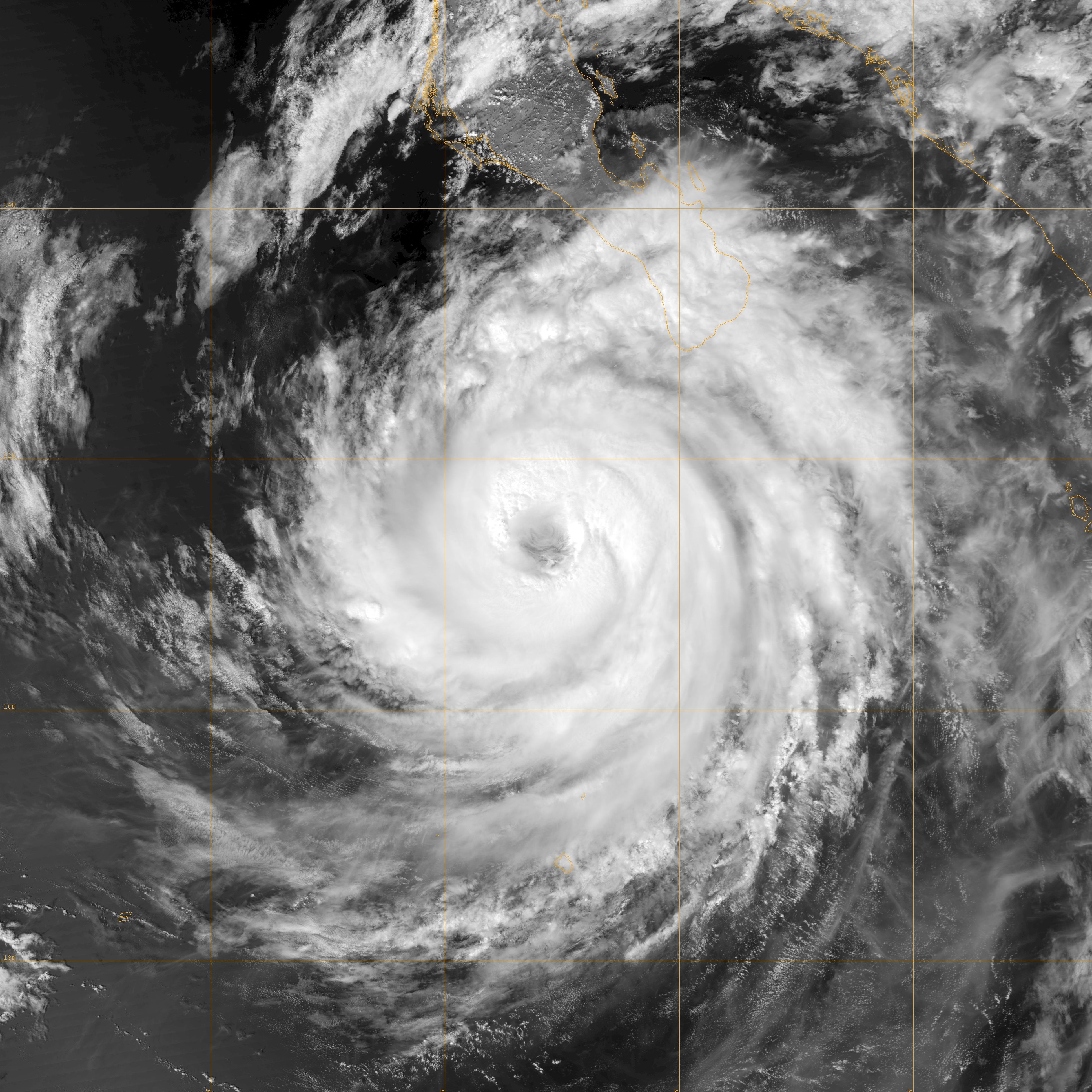
Track=Otis 2005 track.pngSeptember 28
Dissipated=October 3
1-min winds=90
Pressure=970Colima , onSeptember 28 out of an Atlantic wave that crossed into the Pacific (split off from what would become Hurricane Philippe in the Atlantic). Twenty four hours later it was upgraded to Tropical Storm Otis. Early onSeptember 30 it was upgraded to a hurricane, and it reached Category 2 onOctober 1 with 105 mph (170 km/h) winds before weakening again as it drifted very slowly northwards.On
October 2 it took a north-northwesterly turn, moving away from the Baja California peninsula, and instead paralleling the coast, before being downgraded to a depression. The NHC ceased advisories on Otis at 21:00 UTC the next day.
* The NHC's [http://www.nhc.noaa.gov/archive/2005/OTIS.shtml archive on Hurricane Otis] .
* The NHC's [http://www.nhc.noaa.gov/pdf/TCR-EP152005_Otis.pdf Tropical Cyclone Report on Hurricane Otis] .Tropical Depression Sixteen-E
Infobox Hurricane Small
Basin=EPac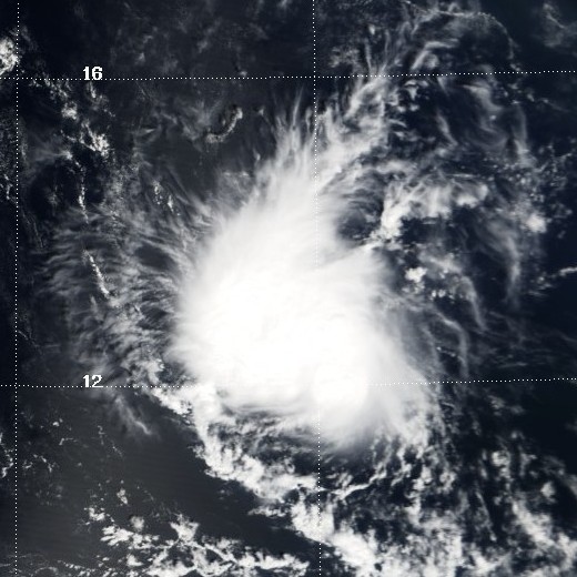
Track=16-E 2005 track.pngOctober 15
Dissipated=October 20
1-min winds=30
Pressure=1005Acapulco ,Guerrero , late onOctober 14 (earlyOctober 15 UTC). Although initial forecasts expected it to strengthen, the depression never gained enough organisation to become a tropical storm and instead appeared to dissipate. Advisories were discontinued onOctober 18 , but resumed onOctober 19 when the remnant low pressure area regenerated deep convection. The system still struggled to develop, apparently due to the entrainment of relatively dry air inhibiting sustained convection. The second final advisory was issued at 2 p.m. PDT (2100 UTC)October 20 . The remnant was absorbed into theITCZ the next day.
* The NHC's [http://www.nhc.noaa.gov/archive/2005/SIXTEEN-E.shtml archive on Tropical Depression Sixteen-E] .
* The NHC's [http://www.nhc.noaa.gov/pdf/TCR-EP162005_Sixteen-E.pdf Tropical Cyclone Report on Tropical Depression Sixteen-E] .torm names
The following names were used for named storms that formed in the northeast Pacific in 2005. This is the same list that was used in the 1999 season. Names that were not assigned are marked in gray. There were no names retired by the WMO in the spring of 2006; therefore, the same list will be reused in the 2011 season.
No central Pacific names were used; the first name used would have been Ioke.
ee also
*
List of Pacific hurricanes
*List of Pacific hurricane seasons
*2005 Atlantic hurricane season
*2005 Pacific typhoon season
*2005 North Indian Ocean cyclone season
*South-West Indian Ocean cyclone seasons: 2004–05, 2005–06
*Australian region cyclone seasons: 2004–05, 2005–06
*South Pacific cyclone seasons: 2004–05, 2005–06References
External links
* [http://www.nhc.noaa.gov/text/MIATWOEP.shtml National Hurricane Center's Eastern Pacific Tropical Weather Outlook] - updated every six hours.
* [http://www.prh.noaa.gov/hnl/cphc/ Central Pacific Hurricane Center]
* [http://www.cpc.ncep.noaa.gov/products/Epac_hurr/Epac_hurricane.html NOAA's 2005 Tropical Eastern North Pacific Hurricane Outlook]
Wikimedia Foundation. 2010.