- Megargel, Texas
-
Megargel, Texas — Town — A row of abandoned shops in Megargel.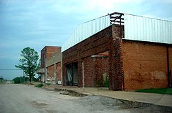 Location of Megargel, Texas
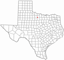

Coordinates: 33°27′14″N 98°55′39″W / 33.45389°N 98.9275°WCoordinates: 33°27′14″N 98°55′39″W / 33.45389°N 98.9275°W Country United States State Texas County Archer Area – Total 0.6 sq mi (1.6 km2) – Land 0.6 sq mi (1.6 km2) – Water 0.0 sq mi (0.0 km2) Elevation 1,286 ft (392 m) Population (2010) – Total 203 – Density 338.3/sq mi (126.9/km2) Time zone Central (CST) (UTC-6) – Summer (DST) CDT (UTC-5) ZIP code 76370 Area code(s) 940 FIPS code 48-47460[1] GNIS feature ID 1362579[2] Megargel (pronounced ME gargle) is a town in Archer County, Texas, United States. It is part of the Wichita Falls, Texas Metropolitan Statistical Area. The population was 203 at the 2010 census. The town is named for Roy C. Megargel, the president of the railroad that developed the town.
Contents
Geography
Megargel is located at 33°27′14″N 98°55′39″W / 33.45389°N 98.9275°W (33.453883, -98.927546)[3].
According to the United States Census Bureau, the town has a total area of 0.6 square miles (1.6 km2), all of it land.
Demographics
As of the census[1] of 2000, there were 248 people, 104 households, and 66 families residing in the town. The population density was 404.4 people per square mile (157.0/km²). There were 132 housing units at an average density of 215.3 per square mile (83.6/km²). The racial makeup of the town was 93.55% White, 0.81% African American, 0.40% Native American, 1.21% Asian, and 4.03% from two or more races. Hispanic or Latino of any race were 6.05% of the population.
There were 104 households out of which 29.8% had children under the age of 18 living with them, 51.0% were married couples living together, 7.7% had a female householder with no husband present, and 35.6% were non-families. 31.7% of all households were made up of individuals and 8.7% had someone living alone who was 65 years of age or older. The average household size was 2.38 and the average family size was 2.97.
In the town the population was spread out with 24.2% under the age of 18, 5.6% from 18 to 24, 29.0% from 25 to 44, 26.6% from 45 to 64, and 14.5% who were 65 years of age or older. The median age was 41 years. For every 100 females there were 100.0 males. For every 100 females age 18 and over, there were 116.1 males.
The median income for a household in the town was $30,000, and the median income for a family was $36,250. Males had a median income of $26,429 versus $23,750 for females. The per capita income for the town was $14,783. About 4.2% of families and 4.3% of the population were below the poverty line, including 1.8% of those under the age of eighteen and none of those sixty five or over.
Education
Megargel is served by the Olney Independent School District.
Megargel was served by the Megargel Independent School District. The April 11, 2006 Dallas Morning News featured the Megargel School [4] in a front page article. The school (along with the town) has been declining for years, and is currently running out of funds. The school board has voted to consolidate with Olney ISD, the neighboring school district in Olney, Texas (about 12 miles southeast), subject to voter approval on May 13, 2006. Proponents argued that the school (which has only 63 students, including only one in seventh grade) simply cannot continue to function, and consolidation with the neighboring district (which has nearly 800 students) would provide more opportunities for educational achievement. Opponents feared that closure of the school would cause the town to disappear.
The vote was in favor of consolidation. The school and district closed after the school year ended.[5]
References
- ^ a b "American FactFinder". United States Census Bureau. http://factfinder.census.gov. Retrieved 2008-01-31.
- ^ "US Board on Geographic Names". United States Geological Survey. 2007-10-25. http://geonames.usgs.gov. Retrieved 2008-01-31.
- ^ "US Gazetteer files: 2010, 2000, and 1990". United States Census Bureau. 2011-02-12. http://www.census.gov/geo/www/gazetteer/gazette.html. Retrieved 2011-04-23.
- ^ "School, town facing demise ." The Dallas Morning News.
- ^ "Mergargel School Closes Its Doors." KAUZ-TV.
External links
Municipalities and communities of Archer County, Texas Cities 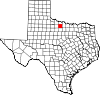
Towns Lakeside City | Megargel | Windthorst‡
Ghost towns Footnotes ‡This populated place also has portions in an adjacent county or counties
Categories:- Populated places in Archer County, Texas
- Towns in Texas
- Wichita Falls metropolitan area


Wikimedia Foundation. 2010.