- Oakdale, Tennessee
-
Oakdale, Tennessee — Town — Location of Oakdale, Tennessee
Coordinates: 35°59′6″N 84°33′25″W / 35.985°N 84.55694°WCoordinates: 35°59′6″N 84°33′25″W / 35.985°N 84.55694°W Country United States State Tennessee County Morgan Area – Total 0.9 sq mi (2.4 km2) – Land 0.9 sq mi (2.4 km2) – Water 0.0 sq mi (0.1 km2) Elevation 843 ft (257 m) Population (2000) – Total 244 – Density 268.2/sq mi (103.5/km2) Time zone Eastern (EST) (UTC-5) – Summer (DST) EDT (UTC-4) ZIP code 37829 Area code(s) 423 FIPS code 47-54280[1] GNIS feature ID 1296163[2] Oakdale is a town located along the Emory River in Morgan County, Tennessee, United States. The population was 244 at the 2000 census.
Contents
History
For much of the 19th century, Oakdale was known as "Honeycutt," after a pioneer family who settled in the area. In the 1880s, the Cincinnati Southern Railway, which connected Chattanooga and Cincinnati, was built through the area, and the town began to expand. This railroad intersected the vast system of the East Tennessee, Virginia and Georgia Railroad (later the Southern Railway) at nearby Emory Gap.[3]
The stretch of the Cincinnati Southern from Oakdale to Somerset, Kentucky, involves steep grades that were too difficult for normal late-19th and early-20th century steam-powered locomotives, so a railyard was set up at Oakdale where trains were modified to allow them to make the trek north. By the early 1900s, Oakdale had developed into an important railroad stop, with a large hotel (the Babahatchie Inn), depot, and a population of around 2,500. The advent of diesel locomotives, which could handle the steep grades without modifications, eliminated the need for the Oakdale railyard, and the town declined in the mid-20th century.[3]
Geography
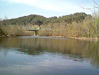
Oakdale is located at 35°59′6″N 84°33′25″W / 35.985°N 84.55694°W (35.984945, -84.557057).[4] The town is situated along the Emory (between river miles 17 and 19) in a relatively hilly area atop the Cumberland Plateau. State highways 299 and 328 intersect at the town's southern boundary, the latter connecting it with Harriman to the south and U.S. Route 27 to the north.
According to the United States Census Bureau, the town has a total area of 0.9 square miles (2.3 km2), of which, 0.9 square miles (2.3 km2) of it is land and 0.04 square miles (0.10 km2) of it is water. The total area is 2.15% water.
Demographics
As of the census[1] of 2000, there were 244 people, 92 households, and 64 families residing in the town. The population density was 268.2 people per square mile (103.5/km²). There were 103 housing units at an average density of 113.2 per square mile (43.7/km²). The racial makeup of the town was 100.00% White, 0.00% African American, 0.00% Native American, 0.00% Asian, 0.00% Pacific Islander, 0.00% from other races, and 0.00% from two or more races. 0.00% of the population were Hispanic or Latino of any race.
There were 92 households out of which 31.5% had children under the age of 18 living with them, 48.9% were married couples living together, 14.1% had a female householder with no husband present, and 30.4% were non-families. 28.3% of all households were made up of individuals and 13.0% had someone living alone who was 65 years of age or older. The average household size was 2.65 and the average family size was 3.25.
In the town the population was spread out with 28.3% under the age of 18, 9.4% from 18 to 24, 29.5% from 25 to 44, 23.8% from 45 to 64, and 9.0% who were 65 years of age or older. The median age was 35 years. For every 100 females there were 98.4 males. For every 100 females age 18 and over, there were 94.4 males.
The median income for a household in the town was $26,667, and the median income for a family was $27,083. Males had a median income of $26,875 versus $21,875 for females. The per capita income for the town was $16,779. 11.6% of the population and 10.1% of families were below the poverty line. Out of the total population, 14.8% of those under the age of 18 and 3.7% of those 65 and older were living below the poverty line.
References
- ^ a b "American FactFinder". United States Census Bureau. http://factfinder.census.gov. Retrieved 2008-01-31.
- ^ "US Board on Geographic Names". United States Geological Survey. 2007-10-25. http://geonames.usgs.gov. Retrieved 2008-01-31.
- ^ a b Barbara Hayes, "Oakdale," An Encyclopedia of East Tennessee (Oak Ridge, Tenn.: Children's Museum of Oak Ridge, 1981), pp. 362-363.
- ^ "US Gazetteer files: 2010, 2000, and 1990". United States Census Bureau. 2011-02-12. http://www.census.gov/geo/www/gazetteer/gazette.html. Retrieved 2011-04-23.
External links
- Oakdale, Tennessee — site maintained by the Oakdale High School Alumni Association
Municipalities and communities of Morgan County, Tennessee Cities 
Towns Oakdale | Oliver Springs‡
Unincorporated
communitiesFootnotes ‡This populated place also has portions in an adjacent county or counties
Categories:- Populated places in Morgan County, Tennessee
- Towns in Tennessee


Wikimedia Foundation. 2010.