- Lake Anna
-
Lake Anna 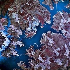
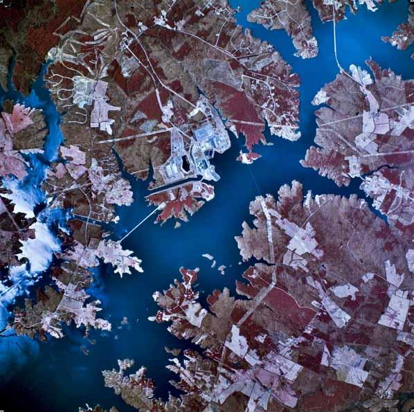
The North Anna Nuclear Generating Station is seen at the center of this aerial photograph. Location Louisa / Spotsylvania / Orange counties, Virginia, USA Coordinates 38°01′26″N 77°43′01″W / 38.023889°N 77.716942°WCoordinates: 38°01′26″N 77°43′01″W / 38.023889°N 77.716942°W Lake type reservoir Basin countries United States Max. length 17 mi (27 km) Surface area 13,000 acres (5,300 ha) Max. depth 80 feet (24 m) Lake Anna is one of the largest freshwater inland lakes in Virginia, covering an area of 13,000 acres (53 km²), and located 72 miles (116 km) south of Washington, D.C. in Louisa and Spotsylvania counties (and partially in Orange County at the northern tips). The lake is easily accessible from Richmond and Charlottesville, and is one of the most popular recreational lakes in the state.
Contents
History
The reservoir is formed by the North Anna Dam on the North Anna River at 38°00′47″N 77°42′46″W / 38.01306°N 77.71278°W. In 1968, Virginia Electric and Power Company (now Dominion) purchased 18,000 acres (73 km²) of farmlands in three counties along the North Anna and Pamunkey Rivers to provide clean, fresh water to cool the nuclear power generating plants at the North Anna Nuclear Generating Station adjacent to the lake.[1] By 1972 the lake bottom was cleared of all timber and the dam was nearing completion. It was projected to take three years to completely fill the lake, but with the additional rainfall from Hurricane Agnes, the lake was full in only 18 months. The first communities broke ground at about that same time and now some 120 different communities dot the shores of the lake. In March 1986, construction on the dam's 1 megawatt hydroelectric power plant began and the two generators went into commercial operation in December 1987.[2] In 2010, a boating accident occurred on the lake, killing a Spotsylvania County Sheriff's deputy.[3]
Description
Lake Anna is approximately 17 miles (27 km) long from tip to tip, with some 200 miles (300 km) of shoreline.[4] The lake is divided into two sides: the public side (also known as the "cold" side) and the private side (also known as the "hot" side). The public side is roughly 9,000 acres (36 km²), while the private side is roughly 4,000 acres (16 km²). The private side is formed of three main bodies of water, connected by navigable canals. The public and private sides are divided by three stone dikes. The private side has no marinas or public access ramps; only property owners and North Anna Power Station employees have access to the waters of the private side. The public side has several marinas and boat launches, including a boat ramp at the state park. The public side sees significantly higher boat traffic than the private side, especially on summer weekends.
The public side is known as the "cold" side because it provides water to cool the generators at the power plant; the private or "hot" side receives warm water discharge from the power plant. The private side can be substantially warmer than the public side, especially near the discharge point, where it can be too hot for swimming. The private side has an extended water sports season. Some water circulates back out of the private side into the public side through underground channels; consequently, the public side is warmer in the southern area near the dam. In the winter, some fish migrate to these warmer waters.
Preliminary steps toward the addition of a third reactor have raised protests from environmentalists and property owners, who fear an increase in the water temperature and a decrease in the water level, particularly on the private side. According to Dominion, the water discharged from the plant is usually about 14 degrees F warmer than the intake water.[4]
North Anna Dam
 North Anna Dam
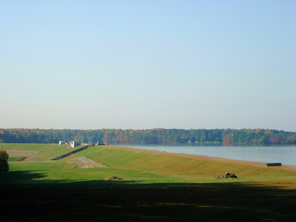
The dam creating the lake, North Anna Dam, is a 5,000 ft (1,524 m) long and 90 ft (27 m) high earthen embankment dam. It is 30 ft (9 m) wide at its crest which sits at an elevation of 265 ft (81 m) above sea level. The dam's spillway is located in the center of its body and is 200 ft (61 m) wide, containing three main 40 ft (12 m) wide and 30 ft (9 m) high radial gates. Two smaller 8.5 ft (3 m) wide and tall gates on the outer edges of the spillway section maintain normal discharges. Normal elevation for the reservoir is 250 ft (76 m).[5] The dam's hydroelectric power plant is located on the west side of the spillway and is supplied with water via a 5 ft (2 m) diameter penstock. The plant consists of two small open runner turbine-generators, the largest with a 775 kw capacity and the smallest rated at 225 kw for a combined installed capacity of 1 MW.[2][6]
Use and recreation
Gaining in popularity as a vacation destination, a retirement destination, and a second home location for many, the manmade lake offers swimming, sailing, boating, world-class fishing, and multiple annual triathlons. Surrounding attractions include vineyards, antique shopping, golf, historic sites, theme parks, and hiking. To get the most out of the lake, one can rent a boat from various local marinas and businesses. Sailboat enthusiasts will prefer the more open, wide water appeal of the southern end of the lake, although the lake's several bridges, including the main 208 bridge, are too low for a sailboat to pass beneath. Water sports junkies tend to enjoy the mid-lake area, while the fishing crowd has lots of hot spots in nooks and crannies of the northern "on Golden pond" end. Anglers fish for over 30 species including largemouth bass, striped bass, walleye, catfish, crappie, bluegill, white perch and yellow perch. Weekly fishing leagues keep local residents happy, while sanctioned tournaments bring fishermen and women from afar.
Lake Anna State Park, complete with picnic areas and boat launching ramps, is located directly on the lake on the public side, making it available to everyone. The park also has a beach area with snack bar, docks, an exhibit center showing how the lake was created, and miles of hiking and horse trails. One can tour the remains of Goodwin gold mine and pan for gold. The original plantation house still stands in ruins and a hiking trail leads to it. The state park offers rental cabins for overnight lodging.[7] Visitors also can stay at waterfront hotels, or in any of dozens of available vacation rental waterfront homes.
Triathlon festivals
Lake Anna is the site of Rumpus in Bumpass, an annual spring triathlon festival, with an International/Olympic-distance race and a sprint-distance race held on consecutive days.[8]
It also hosts the Kinetic Race weekend in May with a half-distance race on Saturday and a sprint-distance race on Sunday
Then, the lake hosts the Giant Acorn triathlon weekend in the fall. This weekend also features an International/Olympic-distance triathlon followed by a sprint-distance triathlon on the next day.[9]
See also
References
- ^ "North Anna Power Station", Dominion. Accessed on June 30, 2009.
- ^ a b "Fish Passage Study For Lake Anna Dam". Virginia Power. http://pbadupws.nrc.gov/docs/ML0202/ML020230069.pdf. Retrieved 23 October 2011.
- ^ "Sheriff's deputy killed in boating accident", WTOP-FM, Washington, DC, 19 June 2010. Retrieved on June 26, 2010.
- ^ a b "Waste Heat Treatment Facility", Dominion. Accessed on June 30, 2009.
- ^ "North Anna Safety Evaluation Report". U.S. Nuclear Regulatory Commission. June 2005. http://www.nrc.gov/reactors/new-reactors/esp/north-anna-ser/section-2-4.pdf. Retrieved 23 October 2011.
- ^ "LACA Tour of Lake Anna Spillway and Dam". Lake Anna Civic Association. http://www.lakeannavirginia.org/LACA_TOUR_OF_LAKE_ANNA_DAM.pdf. Retrieved 23 October 2011.
- ^ "Lake Anna State Park", United States Park Service. Accessed on June 30, 2009.
- ^ "Rumpus in Bumpass", official site. Accessed on April 5, 2010.
- ^ "Giant Acorn triathlon festival", official site. Accessed on April 5, 2010.
Categories:- Reservoirs in Virginia
- Geography of Louisa County, Virginia
- Geography of Orange County, Virginia
- Geography of Spotsylvania County, Virginia
- Visitor attractions in Louisa County, Virginia
- Visitor attractions in Orange County, Virginia
- Visitor attractions in Spotsylvania County, Virginia
Wikimedia Foundation. 2010.