Driftpile River

Driftpile River
Driftpile River

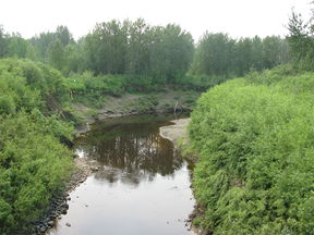
The Dirftpile River near Lesser Slave Lake
Origin Swan Hills
54°52′24″N 115°45′51″W / 54.87333°N 115.76417°W / 54.87333; -115.76417
Mouth Lesser Slave Lake
55°22′37″N 115°38′27″W / 55.37694°N 115.64083°W / 55.37694; -115.64083 (Sturgeon River mouth)
Basin countries Canada
Source elevation 1,153 m (3,783 ft)
Mouth elevation 577 m (1,893 ft)

The Driftpile River is a medium-length river forming in central Alberta. The Drifpile flows into Lesser Slave Lake, which flows out through the Lesser Slave River, a major tributary of the Athabasca River. The Geological Survey of Canada was using the name Driftpile by 1892. The river was named because of the large amount of driftwood that collected at the river's mouth.[1]

The river forms in Swan Hills region of central Alberta and heads north towards Lesser Slave Lake. The Driftpile's main tributary is the Little Driftpile River. The river is bridged by Alberta Highway 2 and flows past the hamlet of Driftpile, Alberta, as well as the Driftpile River First Nation Indian Reserve. [2]

See also

  • List of Alberta rivers

References

  1. ^ Aubrey, Merrily. Place Names of Alberta: Volume IV, Northern Alberta. Calgary: University of Calgary Press, 1996. Page 59.
  2. ^ Mussio Ventures.South Peace Alberta Mapbook. Burnaby: Backroad Mapbooks, 2004.

Wikimedia Foundation. 2010.

Игры ⚽ Нужно сделать НИР?

Look at other dictionaries:

  • Driftpile, Alberta — …   Wikipedia

  • Driftpile First Nation — The Driftpile First Nation (or the Driftpile Cree Nation) is a First Nation with a reserve located on the southern shore of the Lesser Slave Lake in Northern Alberta. The band has approximately 1200 members. v …   Wikipedia

  • Lesser Slave River — Superimpose base = Alberta rivers.png base width = 280px base caption = Alberta rivers float = Map symbol pin.gif float width = 20px float caption = Lesser Slave River x = 146 y = 128 Lesser Slave River in Alberta Lesser Slave River (Cree… …   Wikipedia

  • Lesser Slave River — Lesser Slave RiverVorlage:Infobox Fluss/KARTE fehlt DatenVorlage …   Deutsch Wikipedia

  • Northern Woods and Water Route — Route information …   Wikipedia

  • Lesser Slave Lake — Infobox lake lake name = Lesser Slave Lake image lake = SW Lesser Slave Lake.jpg caption lake = SE corner of the lake from Martin Mountain (looking South). Dog Island, Devonshire Beach, and the town of Slave Lake are visible in the distance.… …   Wikipedia

  • List of rivers of Alberta — Alberta s rivers flow towards three different bodies of water, the Arctic Ocean, the Hudson Bay and the Gulf of Mexico. Alberta is located immediately east of the continental divide, so no rivers from Alberta reach the Pacific Ocean.List of… …   Wikipedia

  • Kleiner Sklavensee — Geographische Lage Alberta (Kanada) Zuflüsse Driftpile River, Assineau River, Swan River …   Deutsch Wikipedia

  • Cree — Verbreitungsgebiet der Cree Gruppen in Kanada (nach einer Vorlage der Brock University Map Library) Die Cree (englisch, auch Kri, französisch: Les Cris) sind ein Indianervolk Nordamerikas. Ihr Stammesgebiet erstreckt sich von den Rocky Mountains… …   Deutsch Wikipedia

  • Liste der First Nations — Die Liste der First Nations beinhaltet alle vom Department of Indian Affairs and Northern Development aufgeführten First Nations in Kanada. Zur Unterscheidung wurde seinerzeit ein Nummernsystem eingeführt, Nummern, die hier mit angegeben sind.… …   Deutsch Wikipedia

Share the article and excerpts

Direct link
Do a right-click on the link above
and select “Copy Link”