- Quill Lakes
-
The Quill Lakes is a wetland complex in Saskatchewan, Canada that encompasses the endorheic basin of three distinct lake wetlands: Big Quill Lake, Middle Quill Lake and Little Quill Lake. On May 27, 1987, it was designated a wetland of international importance via the Ramsar Convention.[1] It was the first Canadian site in the North American Waterfowl Management Plan, is a site in the International Biological Programme and Saskatchewan Heritage Marsh Program, and was designated a Western Hemisphere Shorebird Reserve Network site of International significance in May, 1994.[2][3] The site is an important staging and breeding area for spring and fall migration of shorebirds. The site qualifies as an Important Bird Area for its globally and nationally significant migratory and breeding populations of more than a dozen species of birds.[4]
The lakes were named for bird quills collected near shorelines and shipped to England for use as quill pens. Quill Lakes is Canada's largest saline lake,[5] covering an area of about 635 square kilometres (245 sq mi). Salinity varies within the lakes and with their water levels,[6] but effectively limits the floral diversity of the region.[5] Located directly north of Regina and east of Saskatoon,[7] it is primarily provincial Crown land administered by the Fish and Wildlife Branch of Saskatchewan Environment.[1] The surrounding area, consisting of glacial moraines, is mostly used for agricultural purposes. Big Quill Lake is pear-shaped and approximately 27 km long, measuring 18 km at its widest point. Middle Quill Lake, also known as Mud Lake, is the smallest of the three, about 6 km long and 3 km wide. Little Quill Lake is 24 km long and 11 km wide.[6] Islands located on Middle Quill Lake have been designated provincial wildlife refuges to protect breeding colonies of American White Pelican and Double-crested Cormorant.[1]
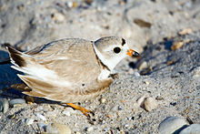
Various studies have surveyed bird populations at this site. The International Shorebird Survey in 1988 counted 155,000 shorebirds at Big Quill Lake. Surveys between 1989 and 1992 at Middle and Little Quill Lakes found one-day peaks of 101,900 birds.[6] The most comprehensive study conducted, involving all three lakes, resulted in a count of 197,155 birds. The site is an important staging and breeding area for the endangered Piping plover. Other species identified throughout the complex include "85,000 geese, 100,000 ducks, [and] 12,000 cranes"[5], as well as the Black-bellied Plover, Sanderlings, Hudsonian Godwit, Red Knot, Stilt Sandpiper, White-rumped Sandpiper, Semipalmated Sandpiper, Long-billed Dowitcher, Red-necked Phalarope, [and] Lesser Yellowlegs".[6] Additionally, in the mid-1990s several Whooping Cranes were observed using the area for staging during fall migration.[4]
Drought in the surrounding regions results in increased water draw from the lakes, reducing the water level and increasing its salinity. This reduces the breeding habitat for the Piping plover.[1]
Big Quill Resources (taken over by Sifto Canada in 2011) operates on the shore of Big Quill Lake extracts naturally occurring sulphate from the brine of the lake then combining it with potassium chloride to form sulphate of potash that is the sold as a fertilizer. [8]
References
- ^ a b c d "Quill Lakes, Saskatchewan - Ramsar Site". Environment Canada. Archived from the original on 2007-05-03. http://replay.web.archive.org/20070503110339/http://www.mb.ec.gc.ca/nature/whp/ramsar/df02s11.en.html. Retrieved 2008-01-28.
- ^ "Western Hemisphere Shorebird Reserve Network (WHSRN)". Environment Canada. Archived from the original on 2008-12-08. http://replay.web.archive.org/20081208235144/http://www.mb.ec.gc.ca/nature/whp/whsrn/index.en.html. Retrieved 2008-01-28.
- ^ "Quill Lakes: Site Description". Western Hemisphere Shorebird Reserve Network. Manomet Center for Conservation Sciences. http://www.whsrn.org/site-profile/quill-lakes. Retrieved 2011-04-28.
- ^ a b "Quill Lakes". IBA Canada. http://www.bsc-eoc.org/iba/site.jsp?siteID=SK002. Retrieved 2008-01-28.
- ^ a b c "The Annotated Ramsar List: Canada". The Annotated Ramsar List of Wetlands of International Importance. Ramsar Convention Bureau. 2000-01-10. Archived from the original on 2007-12-30. http://web.archive.org/web/20071230051034/http://www.ramsar.org/profile/profiles_canada.htm. Retrieved 2008-01-28.
- ^ a b c d "Quill Lakes, Saskatchewan (International)". Western Hemisphere Shorebird Reserve Network. Environment Canada. http://www.mb.ec.gc.ca/nature/whp/whsrn/df01s04.en.html. Retrieved 2008-01-28.
- ^ "Saskatchewan Breeding Bird Survey Routes (Map)" (PDF). Canadian Wildlife Service, Environment Canada. 2005-11-01. http://www.cws-scf.ec.gc.ca/nwrc-cnrf/02CB949F-8306-463B-8741-932FA1DEEF6F/main.pdf. Retrieved 2008-01-28.
- ^ "Saskatchewan Economic New Feb 4, 2011 - Wynyard Updated (Taken from The Humboldt Journal, January 26, 2011)". Enterprise Saskatchewan. http://www.enterprisesaskatchewan.ca/enr020411. Retrieved 2011-02-08.
External links
- Quill Lakes - Encyclopedia of Saskatchewan
Categories:- Lakeview No. 337, Saskatchewan
- Ramsar sites in Canada
- Lakes of Saskatchewan
- Important Bird Areas of Canada
Wikimedia Foundation. 2010.

