- Donnybrook, North Dakota
-
Donnybrook, North Dakota — City — The post office and city hall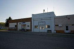 Location of Donnybrook, North Dakota
Coordinates: 48°30′36″N 101°53′7″W / 48.51°N 101.88528°WCoordinates: 48°30′36″N 101°53′7″W / 48.51°N 101.88528°W Country United States State North Dakota County Ward Area – Total 0.7 sq mi (1.8 km2) – Land 0.7 sq mi (1.8 km2) – Water 0.0 sq mi (0.0 km2) Elevation 1,772 ft (540 m) Population (2010)[1] – Total 59 – Density 128.5/sq mi (49.6/km2) Time zone Central (CST) (UTC-6) – Summer (DST) CDT (UTC-5) ZIP code 58734 Area code(s) 701 FIPS code 38-19900[2] GNIS feature ID 1028703[3] Donnybrook is a city in Ward County, North Dakota in the United States. The population was 59 at the 2010 census.[1] It is part of the Minot Micropolitan Statistical Area.
The first place named Donnybrook was founded in 1895 and named after Donnybrook Fair in Ireland. In 1897, the postmaster of this site changed the name to Goetz. The name Donnybrook was then reused in 1898 when a new town formed to the west of Goetz along the main line of the Soo Line Railroad.[4]
Geography
Donnybrook is located at 48°30′36″N 101°53′7″W / 48.51°N 101.88528°W (48.510014, -101.885410)[5].
According to the United States Census Bureau, the city has a total area of 0.7 square miles (1.8 km2), all of it land.
Demographics
Historical populations Census Pop. %± 1910 297 — 1920 267 −10.1% 1930 259 −3.0% 1940 215 −17.0% 1950 207 −3.7% 1960 196 −5.3% 1970 163 −16.8% 1980 139 −14.7% 1990 106 −23.7% 2000 90 −15.1% 2010 59 −34.4% U.S. Decennial Census As of the census[2] of 2000, there were 90 people, 36 households, and 28 families residing in the city. The population density was 128.5 people per square mile (49.6/km²). There were 46 housing units at an average density of 65.7 per square mile (25.4/km²). The racial makeup of the city was 95.56% White, 4.44% from other races. Hispanic or Latino of any race were 6.67% of the population.
There were 36 households out of which 36.1% had children under the age of 18 living with them, 69.4% were married couples living together, 2.8% had a female householder with no husband present, and 22.2% were non-families. 22.2% of all households were made up of individuals and 13.9% had someone living alone who was 65 years of age or older. The average household size was 2.50 and the average family size was 2.93.
In the city the population was spread out with 25.6% under the age of 18, 5.6% from 18 to 24, 20.0% from 25 to 44, 32.2% from 45 to 64, and 16.7% who were 65 years of age or older. The median age was 44 years. For every 100 females there were 100.0 males. For every 100 females age 18 and over, there were 116.1 males.
The median income for a household in the city was $32,500, and the median income for a family was $31,250. Males had a median income of $28,750 versus $17,500 for females. The per capita income for the city was $14,599. There were 8.3% of families and 10.1% of the population living below the poverty line, including no under eighteens and 25.0% of those over 64.
References
- ^ a b "2010 Census Redistricting Data (Public Law 94-171) Summary File". American FactFinder. United States Census Bureau. http://factfinder2.census.gov/faces/tableservices/jsf/pages/productview.xhtml?pid=DEC_10_PL_GCTPL2.ST13&prodType=table. Retrieved 2 May 2011.
- ^ a b "American FactFinder". United States Census Bureau. http://factfinder.census.gov. Retrieved 2008-01-31.
- ^ "US Board on Geographic Names". United States Geological Survey. 2007-10-25. http://geonames.usgs.gov. Retrieved 2008-01-31.
- ^ Wick, Douglas A.. "Donnybrook (Ward County)". North Dakota Place Names. http://www.webfamilytree.com/North_Dakota_Place_Names/D/donnybrook_%28ward_county%29.htm. Retrieved 7 May 2011.
- ^ "US Gazetteer files: 2010, 2000, and 1990". United States Census Bureau. 2011-02-12. http://www.census.gov/geo/www/gazetteer/gazette.html. Retrieved 2011-04-23.
Municipalities and communities of Ward County, North Dakota Cities 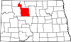
Townships Afton | Anna | Baden | Berthold | Brillian | Burlington | Burt | Cameron | Carbondale | Carpio | Denmark | Des Lacs | Elmdale | Eureka | Evergreen | Foxholm | Freedom | Gasman | Greely | Greenbush | Harrison | Hiddenwood | Hilton | Iota Flat | Kenmare | Kirkelie | Linton | Lund | Mandan | Margaret | Maryland | Mayland | McKinley | Nedrose | New Prairie | Newman | Orlien | Passport | Ree | Rice Lake | Rolling Green | Ruthville | Rushville | Ryder | St. Marys | Sauk Prairie | Sawyer | Shealy | Spencer | Spring Lake | Sundre | Surrey | Tatman | Tolgen | Torning | Vang | Waterford | Willis
CDPs Foxholm | Logan | Minot AFB | Ruthville
Unincorporated
communitiesAurelia | Drady | Hartland | Hesnault | Lynch | Lonetree | Ralston | Rice Lake | Roach | Wolseth
Categories:- Cities in North Dakota
- Populated places in Ward County, North Dakota
- Populated places established in 1895
- Minot micropolitan area


Wikimedia Foundation. 2010.