- Deer's Mill, Indiana
-
Deer's Mill — Town — 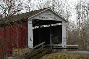

 Deer's Mill
Coordinates: 39°56′46″N 87°03′33″W / 39.94611°N 87.05917°WCoordinates: 39°56′46″N 87°03′33″W / 39.94611°N 87.05917°W Country United States State Indiana County Montgomery Township Ripley Elevation 633 ft (193 m) ZIP code 47933 FIPS code 18-17336[1] GNIS feature ID 433435[2] Deer's Mill is an unincorporated town in Ripley Township, Montgomery County, Indiana.
Contents
History
Deer's Mill was built by Joel Deer in 1829.
A year after arriving in Montgomery County, in 1829, Joel built the township's first grist and saw mill along the banks of Sugar Creek. It was called appropriately, Deer's Mill, and that small corner of Montgomery County retains that name to this day. The original millhouse was of log construction with common stones, and primarily ground wheat and corn.
In 1833, Joel platted a small village adjacent to the mill. It was at various times known as Deer's Mill, Deerfield, Deerford, and Bluff Mill. The community, however, never quite developed, and any remnants have long since vanished. Deer's Mill, however, did a thriving business, and in 1839, Joel replaced the original log structure with one made of frame construction. Over time, a woolen mill and general store were added to the Deer's Mill enterprise.[3]
Bridge
The Deer's Mill bridge was built in 1878 by J. J. Daniels and spans 275 feet across Sugar Creek. [3]
 Deer's Mill Covered Bridge
Geography
Deer's Mill is located at 39°56′46″N 87°03′33″W / 39.94611°N 87.05917°W.
References
- ^ "American FactFinder". United States Census Bureau. http://factfinder.census.gov. Retrieved 2008-01-31.
- ^ "Deer's Mill, Indiana". Geographic Names Information System, U.S. Geological Survey. http://geonames.usgs.gov/pls/gnispublic/f?p=gnispq:3:::NO::P3_FID:433435. Retrieved 2009-10-10.
- ^ a b Montgomery County, Indiana USGenWeb Project
Municipalities and communities of Montgomery County, Indiana City 
Towns Alamo | Darlington | Ladoga | Linden | New Market | New Richmond | New Ross | Waveland | Waynetown | Wingate
Townships Unincorporated
communitiesBalhinch | Beckville | Bowers | Browns Valley | Cherry Grove | Darlington Woods | Deer's Mill | Elmdale | Fiskville | Garfield | Hibernia | Kirkpatrick | Lake Holiday | Lapland | Linnsburg | Log Cabin Crossroads | Mace | Manchester | North Union | Parkersburg | Shannondale | Smartsburg | Sycamore Ford | Taylor Corner | Wesley | Whitesville | Yountsville
Categories:- Populated places in Montgomery County, Indiana
- Unincorporated communities in Indiana


Wikimedia Foundation. 2010.