- Darlington, Indiana
-
Town of Darlington, Indiana — Town —  Location in the state of Indiana
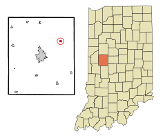
Coordinates: 40°6′30″N 86°46′36″W / 40.10833°N 86.77667°WCoordinates: 40°6′30″N 86°46′36″W / 40.10833°N 86.77667°W Country United States State Indiana County Montgomery Township Franklin Area - Total 0.3 sq mi (0.8 km2) - Land 0.3 sq mi (0.8 km2) - Water 0.0 sq mi (0.0 km2) Elevation 755 ft (230 m) Population (2010) - Total 843 - Density 2,668.7/sq mi (1,030.4/km2) Time zone EST (UTC-5) - Summer (DST) EST (UTC-5) ZIP code 47940 Area code(s) 765 FIPS code 18-16840[1] GNIS feature ID 0433318[2] Website http://www.darlingtonconnection.com Darlington is a town in Franklin Township, Montgomery County, Indiana, United States. The population was 843 at the 2010 census.
Contents
History
Darlington was platted by Enoch Cox in 1836.[3]
The Pennsylvania Rail Road (Vandalia district) made stops in Darlington for many years from the late 19th century up until the 1960s. The right-of-way can still be seen to this day along state road 47 with its numerous wood-pile trestles. Many people in Darlington would ride the PRR to Lake Maxinkuckee on weekends during the late 19th and early 20th centuries.
The Vandalia District started southwest of Terre Haute and bi-sected Montgomery County from Waveland, through Crawfordsville, to Darlington, continuing on to Colfax where it crossed the NYC Big Four branch.
On June 2, 1990 an F-3 tornado touched down southwest of Darlington and destroyed multiple homes, barns, and property around the area. The town suffered significant damage from the storm.
Geography
Darlington is located at 40°6′30″N 86°46′36″W / 40.10833°N 86.77667°W (40.108218, -86.776555)[4].
According to the United States Census Bureau, the town has a total area of 0.3 square miles (0.78 km2), all of it land.
Demographics
As of the census[1] of 2000, there were 854 people, 331 households, and 232 families residing in the town. The population density was 2,706.9 people per square mile (1,030.4/km²). There were 359 housing units at an average density of 1,137.9 per square mile (433.2/km²). The racial makeup of the town was 99.18% White, 0.12% Asian, 0.23% from other races, and 0.47% from two or more races. Hispanic or Latino of any race were 0.47% of the population.
There were 331 households out of which 36.9% had children under the age of 18 living with them, 54.1% were married couples living together, 11.5% had a female householder with no husband present, and 29.9% were non-families. 27.2% of all households were made up of individuals and 13.6% had someone living alone who was 65 years of age or older. The average household size was 2.58 and the average family size was 3.13. The town has a local Mini Mart where many regulars eat lunch and breakfast.
In the town the population was spread out with 31.6% under the age of 18, 5.2% from 18 to 24, 30.3% from 25 to 44, 18.3% from 45 to 64, and 14.6% who were 65 years of age or older. The median age was 34 years. For every 100 females there were 91.1 males. For every 100 females age 18 and over, there were 87.8 males.
The median income for a household in the town was $36,250, and the median income for a family was $43,462. Males had a median income of $35,463 versus $21,310 for females. The per capita income for the town was $15,154. About 5.3% of families and 7.1% of the population were below the poverty line, including 7.1% of those under age 18 and 8.5% of those age 65 or over.
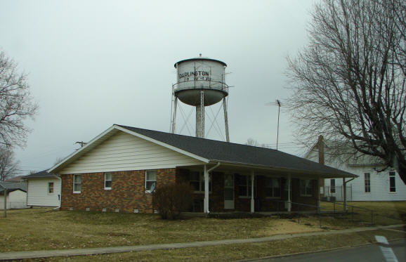
 Water Tower
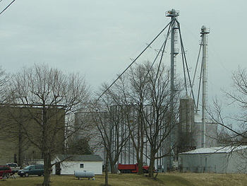 Grain Storage
Government
Currently the town utilizes a three-member town board who oversees operations of the town's municipal utilities including sewage, power, parks, and street maintenance. The town's drinking water is provided by Aqua corporation.
The town employs a town marshal, although nearly all law enforcement services are provided by the Montgomery County Sheriff Department and the Indiana State Police.
Fire service is provided by Darlington Community Volunteer Fire Department, INC. The Fire department exists as its own entity.
Festivals
Early each fall, the town hosts Old Fashioned Days in the downtown and park areas. There is a softball tournament, street festival, bands and entertainers, and a large tractor show.
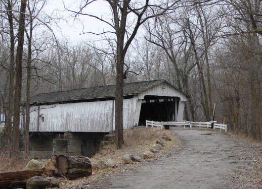
Covered Bridge
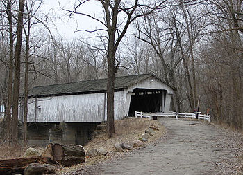 The Darlington Covered Bridge
The Darlington Covered Bridge is 0.6 miles West of town. It was built in 1868 and is 166' long.
It was built as a result of donations from Darlington citizens who saw a need for a bridge over Sugar Creek and raised $1,585.00 in 1866. There was both the bridge and a mill on the site. Only the bridge remains.[5]
References
- ^ a b "American FactFinder". United States Census Bureau. http://factfinder.census.gov. Retrieved 2008-01-31.
- ^ "US Board on Geographic Names". United States Geological Survey. 2007-10-25. http://geonames.usgs.gov. Retrieved 2008-01-31.
- ^ History of Montgomery County, Indiana : with personal sketches of representative citizens. pg 504
- ^ "US Gazetteer files: 2010, 2000, and 1990". United States Census Bureau. 2011-02-12. http://www.census.gov/geo/www/gazetteer/gazette.html. Retrieved 2011-04-23.
- ^ Indiana Historical Bureau - Darlington Covered Bridge Marker
External links
Municipalities and communities of Montgomery County, Indiana City 
Towns Alamo | Darlington | Ladoga | Linden | New Market | New Richmond | New Ross | Waveland | Waynetown | Wingate
Townships Unincorporated
communitiesBalhinch | Beckville | Bowers | Browns Valley | Cherry Grove | Darlington Woods | Deer's Mill | Elmdale | Fiskville | Garfield | Hibernia | Kirkpatrick | Lake Holiday | Lapland | Linnsburg | Log Cabin Crossroads | Mace | Manchester | North Union | Parkersburg | Shannondale | Smartsburg | Sycamore Ford | Taylor Corner | Wesley | Whitesville | Yountsville
Categories:- Populated places in Montgomery County, Indiana
- Towns in Indiana


Wikimedia Foundation. 2010.