- Crowsnest Formation
-
Crowsnest Formation
Stratigraphic range: Mid to Upper Albian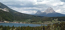
Crowsnest Formation exposed in the Crowsnest PassType Geological formation Underlies Blackstone Formation Overlies Ma Butte Formation Thickness up to 404 metres (1,330 ft)[1] Lithology Primary Air-fall pyroclastic flow, lahar Other pyroclastic breccia Location Named for Crowsnest Pass Named by G.M. Dawson, 1886[2] Coordinates 49°38′51″N 114°31′48″W / 49.6475°N 114.53°WCoordinates: 49°38′51″N 114°31′48″W / 49.6475°N 114.53°W Country  Canada
The Crowsnest Formation, also called the Crowsnest Volcanics, is a well-known outcroping of volcanic rock in southwestern Alberta, Canada. These volcanics were formed about 100 million years ago during the Cretaceous period and is estimated to cover a volume of 209 km3 (50 cu mi). These volcanics are older than the Rocky Mountains and are essentially the eroded remnants of an alkaline volcanic center that was erupted in a fluvial environment.[3]
See also
- Volcanism of Canada
- Volcanism of Western Canada
- Geography of Alberta
References
- ^ Lexicon of Canadian Geological Units. "Crowsnest Formation". http://cgkn1.cgkn.net/weblex/weblex_litho_detail_e.pl?00053:003600. Retrieved 2009-02-06.
- ^ Dawson, G.M. 1886a. Preliminary report on the physical and geological features of that portion of the Rocky Mountains, between latitudes 49 and 51 30'. Geological and Natural History Survey of Canada, Annual Report, v. 1, p. 1B-169B.
- ^ Analcime phenocrysts in igneous rocks: Primary or secondary? - Discussion

This article about a specific Canadian geological feature is a stub. You can help Wikipedia by expanding it.
