- Bellmawr, New Jersey
Infobox Settlement
official_name = Bellmawr, New Jersey
settlement_type = Borough
nickname =
motto =
imagesize =
image_caption =
image_
imagesize =
image_caption =
image_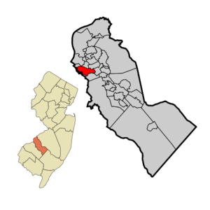
mapsize = 250x200px
map_caption = Bellmawr highlighted in Camden County. Inset: Location of Camden County highlighted in the State of New Jersey.
mapsize1 = 250x200px
map_caption1 = Census Bureau map of Bellmawr, New Jerseysubdivision_type = Country
subdivision_name =United States
subdivision_type1 = State
subdivision_name1 =New Jersey
subdivision_type2 = County
subdivision_name2 = Camden
government_footnotes =
government_type =Borough (New Jersey)
leader_title =Mayor
leader_name = Frank Filipek
leader_title1 =
leader_name1 =
established_title = Incorporated
established_date =April 21 ,1926 unit_pref = Imperial
area_footnotes =
area_magnitude =
area_total_km2 = 8.1
area_land_km2 = 7.9
area_water_km2 = 0.3
area_total_sq_mi = 3.1
area_land_sq_mi = 3.0
area_water_sq_mi = 0.1population_as_of = 2006
population_footnotes =
population_total = 11193
population_density_km2 = 1434.6
population_density_sq_mi = 3715.5timezone = Eastern (EST)
utc_offset = -5
timezone_DST = EDT
utc_offset_DST = -4
elevation_footnotes = [Gnis|885154|Borough of Bellmawr,Geographic Names Information System . AccessedJanuary 4 ,2008 .]
elevation_m = 21
elevation_ft = 69
latd = 39 |latm = 51 |lats = 57 |latNS = N
longd = 75 |longm = 05 |longs = 41 |longEW = Wpostal_code_type =
ZIP code s
postal_code = 08031, 08099
area_code = 856
blank_name = FIPS code
blank_info = 34-04750GR|2 [ [http://mcdc2.missouri.edu/webrepts/commoncodes/ccc_nj.html A Cure for the Common Codes: New Jersey] , Missouri Census Data Center. AccessedJuly 14 ,2008 .]
blank1_name = GNIS feature ID
blank1_info = 0885154GR|3
website = http://www.bellmawr.com
footnotes =Bellmawr is a Borough in Camden County,
New Jersey ,United States . As of theUnited States 2000 Census , the borough population was 11,262.Bellmawr was incorporated as a borough on
March 23 ,1926 , from portions of the now-defunct Centre Township, based on the results of a referendum held onApril 21 ,1926 . The boroughs of Mount Ephraim, Runnemede and Lawnside were also created in the same two-day period."The Story of New Jersey's Civil Boundaries: 1606-1968", John P. Snyder, Bureau of Geology and Topography; Trenton, New Jersey; 1969. p. 103.]Bellmawr is home to the main
post office for the area, one of the largest in the state of New Jersey. In late October 2001 the office was closed due to possibleanthrax contamination (see2001 anthrax attacks ). The office was re-opened several days later, in early November, after testing negative for anthrax.Geography
Bellmawr is located at coor dms|39|52|1|N|75|5|30|W|city (39.867013, -75.091622)GR|1.
According to the
United States Census Bureau , the borough has a total area of 3.1square mile s (8.1km² ), of which, 3.0 square miles (7.8 km²) of it is land and 0.1 square miles (0.3 km²) of it (3.18%) is water.Bellmawr borders Barrington, Brooklawn, Gloucester City, Haddon Heights, Mount Ephraim, and Runnemede. Bellmawr also borders Gloucester County.
Demographics
USCensusPop
1930= 1123
1940= 1250
1950= 5213
1960= 11853
1970= 15618
1980= 13721
1990= 12603
2000= 11262
estimate=11193
estyear=2006
estref= [http://factfinder.census.gov/servlet/SAFFPopulation?_event=Search&geo_id=16000US3403250&_geoContext=01000US%7C04000US34%7C16000US3403250&_street=&_county=bellmawr&_cityTown=bellmawr&_state=04000US34&_zip=&_lang=en&_sse=on&ActiveGeoDiv=geoSelect&_useEV=&pctxt=fph&pgsl=160&_submenuId=population_0&ds_name=null&_ci_nbr=null&qr_name=null®=null%3Anull&_keyword=&_industry= Census data for Bellmawr borough] ,United States Census Bureau . AccessedJune 12 ,2008 .]
footnote=Population 1930 - 1990. [ [http://www.wnjpin.net/OneStopCareerCenter/LaborMarketInformation/lmi01/poptrd6.htm New Jersey Resident Population by Municipality: 1930 - 1990] , Workforce New Jersey Public Information Network. AccessedMarch 1 ,2007 .] As of thecensus GR|2 of 2000, there were 11,262 people, 4,446 households, and 3,134 families residing in the borough. Thepopulation density was 3,715.5 people per square mile (1,435.1/km²). There were 4,561 housing units at an average density of 1,504.7/sq mi (581.2/km²). The racial makeup of the borough was 92.79% White, 1.18% African American, 0.06% Native American, 3.05% Asian, 0.02% Pacific Islander, 1.54% from other races, and 1.36% from two or more races. Hispanic or Latino of any race were 3.50% of the population.There were 4,446 households out of which 26.9% had children under the age of 18 living with them, 52.3% were married couples living together, 12.6% had a female householder with no husband present, and 29.5% were non-families. 25.3% of all households were made up of individuals and 11.1% had someone living alone who was 65 years of age or older. The average household size was 2.53 and the average family size was 3.02.
In the borough the population was spread out with 20.8% under the age of 18, 8.4% from 18 to 24, 28.8% from 25 to 44, 24.6% from 45 to 64, and 17.5% who were 65 years of age or older. The median age was 40 years. For every 100 females there were 96.5 males. For every 100 females age 18 and over, there were 94.9 males.
The median income for a household in the borough was $44,653, and the median income for a family was $53,839. Males had a median income of $38,646 versus $27,050 for females. The
per capita income for the borough was $19,863. About 2.6% of families and 4.0% of the population were below thepoverty line , including 3.7% of those under age 18 and 5.2% of those age 65 or over.Government
Local government
Bellmawr is governed under the Borough form of New Jersey municipal government. The government consists of a Mayor and a Borough Council comprising six council members, with all positions elected at large. A Mayor is elected directly by the voters to a four-year term of office. The Borough Council consists of six members elected to serve three-year terms on a staggered basis, with two seats coming up for election each year. ["2005 New Jersey Legislative District Data Book",
Rutgers University Edward J. Bloustein School of Planning and Public Policy , April 2005, p. 28.]The
Mayor of the Borough of Bellmawr is Frank Filipek. Members of the Bellmawr Borough Council are John Bollinger, James D'Angelo, Louis DiAngelo, Peter DiGiambattista, Regina Piontkowski and Stephen Sauter. [ [http://www.bellmawr.com/borohall.htm Borough of Bellmawr 2006] , Borough of Bellmawr. AccessedMarch 8 ,2008 .]Federal, state and county representation
Bellmawr is in the First Congressional District and is part of New Jersey's 5th Legislative District. [ [http://www.lwvnj.org/pubs/CG06.pdf 2006 New Jersey Citizen's Guide to Government] , New Jersey
League of Women Voters . p. 54. AccessedAugust 30 ,2006 .]Education
The
Bellmawr School District serves public school students in pre-kindergarten through eighth grade. Schools in the district (with 2005-06 enrollment data from theNational Center for Education Statistics [ [http://nces.ed.gov/ccd/schoolsearch/school_list.asp?Search=1&DistrictID=3401380 Data for the Bellmawr School District] ,National Center for Education Statistics . AccessedJune 12 ,2008 .] ) are [http://www.bellmawrschools.org/Burke/Bellmawr%20Park/BellmawrPark.html Bellmawr Park] (403 students) and [http://www.bellmawrschools.org/Burke/Burke.html Ethel M. Burke] (226) for preK-4 and [http://www.bellmawrschools.org/Bell%20Oaks/Bell%20Oaks.html Bell Oaks Upper Elementary School] (458) for grades 5-8.For grades 9 through 12, public students attend
Triton Regional High School (1,525 students), one of three high schools that are part of theBlack Horse Pike Regional School District . The other communities in the district are Gloucester Township and Runnemede. [ [http://education.state.nj.us/rc/rc07/narrative/07/0390/07-0390-050.html Triton Regional High School 2007 Report Card Narrative] ,New Jersey Department of Education . AccessedJune 12 ,2008 . "Triton houses over 1500 students residing in Runnemede, Bellmawr, and Gloucester Township."] The two other schools in the district areHighland Regional High School andTimber Creek Regional High School .Annunciation Regional School is an elementary school that operates under the auspices of the
Roman Catholic Diocese of Camden . [ [http://www.camdendiocese.org/schools/cc.html Camden County Schools] ,Roman Catholic Diocese of Camden . AccessedJuly 10 ,2008 .]Transportation
New Jersey Transit bus service is available toPhiladelphia on the 400 route. [ [http://www.njtransit.com/sf_tp_rc_camden.shtml Camden County Bus/Rail Connections] ,New Jersey Transit . AccessedJune 21 ,2007 .]Various roads pass through Bellmawr, such as NJ 168, and very small portion of US 130. In terms of major highways, Bellmawr hosts the interchange with the "North-South Freeway" (NJ 42/I-76) and the 295 expressway. The
New Jersey Turnpike passes through the southern part, hosting part of an interchange: Exit 3. Half of the interchange is Bellmawr, while the other part is in Runnemede. The Exit 3 toll gate is right on the line between Bellmawr and Runnemede, with a total of six lanes.References
External links
* [http://www.bellmawr.com/ Bellmawr Borough municipal website]
* [http://www.bellmawrschools.org/ Bellmawr School District]
*NJReportCard|07|0260|0|Bellmawr School District
* [http://nces.ed.gov/ccd/schoolsearch/school_list.asp?Search=1&DistrictID=3401380 Data for the Bellmawr School District] ,National Center for Education Statistics
* [http://www.bhprsd.org/ Black Horse Pike Regional School District]
* [http://www.courierpostonline.com/blogs/bellmawr.html Courier Post Newspaper - Town Blogger 1]
* [http://www.courierpostonline.com/blogs/bellmawr2.html Courier Post Newspaper - Town Blogger 2]
Wikimedia Foundation. 2010.