- Iroise Sea
-
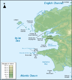 Map of the Iroise Sea
The Iroise Sea or Mer d'Iroise is the part of the Atlantic Ocean which stretches from the Ile de Sein to Ushant off the coast of Brittany in north-western France. It borders on the English Channel to the north, the Celtic Sea to the west and the Bay of Biscay to the south. The origin of the name is not clear.[1] It appears to be fairly recent dating back to the 17th century when naval maps referred to the Passage de l'Iroise.[2]
It is one of the most dangerous seas in Europe. In winter, there are often violent storms with huge waves. But it is also considered to be one of the richest areas for marine life leading to its inclusion as one of UNESCO's biosphere reserves in 1988 and as France's first marine park in October 2007.[3]
Contents
Location and environment
The Iroise coastline consists of a rich variety of beaches, rocky cliffs, sand dunes, coves and islands such as the Ile de Sein and the Island of Molene.
The considerable differences in depth and the adjacent English Channel are responsible for the strong currents through the Iroise. High tides in the Channel bring about strong north-easterly currents which reverse at low tide. The currents can reach particularly high speeds at the Raz de Sein or the Goulet de Brest.
As a result, there are many lighthouses is the area and many local legends describing tragedies at sea.
Activities
The Iroise Sea enjoys a variety of activities. The French navy has been present there since 1631 when Brest became a naval base and, more recently, it has been a centre of submarine activity owing to the nuclear submarine base at Ile Longue on the Crozon peninsula in the roadstead of Brest. Fishing, though less important than in the past, is still practiced especially through the ports of Le Conquet, Douarnenez, Camaret and Brest where catches range from crabs to sardines and monkfish. The area is also popular for sailing and pleasure boating, particularly in the less exposed areas along the coast and in the Douarnenez Bay. Diving is also increasingly popular, particularly in view of the many accessible wrecks and spectacular underwater vistas.
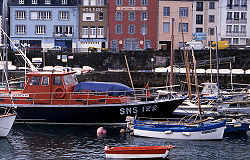 SNSM lifeboat in the port of Douarnenez
Sea search and rescue
Owing to the hazardous conditions at sea, the high density of shipping and a number of shipwrecks in recent years, the French authorities have introduced special search and rescue operations which include vessels such as the Abeille Bourbon as well as a number of large lifeboats in the ports of Douarnenez, Camaret, Le Conquet, Molène and Ushant.
Marine Park
Despite several major oil spills and cases of overfishing, the Iroise Sea is still rich in flora and fauna. It is especially well known for its seabass, its shoals of dolphin, seals, sea otters, lobsters and, on occasion, sunfish, basking shark and even whales. There are also many varieties of seabird including cormorants, guillemots and herons. The sea is also recognized as the richest environment for seaweed in Europe with some 300 species. As a result, on 2 October 2007, after years of debate and discussion, the French authorities created the country's very first marine park, officially labelled Parc naturel marin d'Iroise. The three main objectives are to increase knowledge of the marine environment, to protect the area's habitats and species and to develop marine activities of all kinds. The Iroise Marine Park covers an area of 3550 km²[4] from latitude 48°31'N (the north coast of Ushant) and latitude 47°59'N (south coast of the Ile de Sein), the mainland coastline to the east except for the Rade de Brest, and the 12-nautical-mile (22 km) limit on French territorial waters to the west.
Footnotes
- ^ L'origine du nom from French government website Mer d'Iroise. Mission pour un parc marin (retrieved October 2007)
- ^ Map of the English Channel dated 1692 from the Collections Online, National Maritime Museum (retrieved October 2007)
- ^ Parc naturel marin d'Iroise - Official Site
- ^ French government map showing the park's boundaries
Categories:- Geography of Brittany
- Marginal seas of the Atlantic Ocean
- Marine parks of France
- Biosphere reserves of France


Wikimedia Foundation. 2010.