- Oglala National Grassland
-
Oglala National Grassland IUCN Category VI (Managed Resource Protected Area)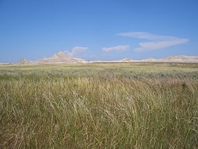
Oglala National Grassland

Location Sioux County and Dawes County, Nebraska, USA Nearest city Crawford, NE Coordinates 42°51′52″N 103°37′13″W / 42.86444°N 103.62028°WCoordinates: 42°51′52″N 103°37′13″W / 42.86444°N 103.62028°W Area 94,520 acres (147.7 sq mi; 382.5 km2) Governing body U.S. Forest Service The Oglala National Grassland is a United States National Grassland in the northwest corner of Nebraska. It is in northern Sioux and northwestern Dawes counties, on the borders with South Dakota and Wyoming. It is 94,520 acres (147.69 sq mi, or 382.5 km2) in size and is one of the small handful of National Grasslands administered by the US Department of Agriculture's Forest Service. It is managed by the Forest Service together with the Nebraska and Samuel R. McKelvie National Forests and the Buffalo Gap and Fort Pierre National Grasslands from common offices in Chadron, Nebraska.
Oglala National Grassland is home to some of the most striking badlands formations in Toadstool Geologic Park (near Crawford, Nebraska and Whitney, Nebraska). Additionally, the Hudson-Meng Bison Kill, also located on the grassland, is an archaeological excavation in progress. The grassland also contains the Agate, Bordgate, and Rock Bass reservoirs.
External links
Federal National MonumentsNational Historic TrailsNational Recreation AreasNational Wildlife RefugesOglala
State State ParksChadron · Eugene T. Mahoney · Fort Robinson · Indian Cave · Niobrara · Platte River · Ponca · Smith Falls
State Historical ParksAshfall Fossil Beds · Ash Hollow · Arbor Lodge · Bowring Ranch · Buffalo Bill Ranch · Champion Mills · Fort Atkinson · Fort Hartsuff · Fort Kearny · Rock Creek Station
State Recreation AreasAlexandria · Arnold · Atkinson Lake · Blue River · Bluestem · Bowman Lake · Box Butte Reservoir · Branched Oak · Bridgeport · Brownville · Calamus · Champion Lake · Cheyenne · Conestoga · Cottonmill · Crystal Lake · Dead Timber · DLD · Enders Reservoir · Fort Kearny · Fremont Lakes · Gallagher Canyon · Johnson Lake · Keller Park · Lake Maloney · Lake McConaughy · Lake Minatare · Lake Ogallala · Lewis and Clark · Long Lake · Long Pine · Louisville · Medicine Creek · Memphis · Merritt Reservoir · Mormon Island · North Loup · Olive Creek · Oliver Reservoir · Pawnee Lake · Pelican Point · Pibel Lake · Pioneer · Red Willow Reservoir · Riverview Marina · Rock Creek Lake · Rock Creek Station · Rockford · Sandy Channel · Schramm Park · Sherman Reservoir · Stagecoach · Summit Lake · Sutherland Reservoir · Swanson Reservoir · Two Rivers · Union Pacific · Verdon · Victoria Springs · Wagon Train · Walgren Lake · War Axe · Wildcat Hills · Willow Creek · Windmill
State Recreation TrailsCategories:- IUCN Category VI
- Protected areas of Dawes County, Nebraska
- Federal lands in Nebraska
- National Grasslands of the United States
- Protected areas of Nebraska
- Protected areas of Sioux County, Nebraska
- Nebraska geography stubs
- Midwestern United States protected area stubs


Wikimedia Foundation. 2010.