- Crawford, Nebraska
-
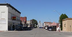
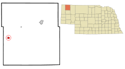
Crawford, Nebraska — City — Downtown Crawford: 2nd Street, looking north from Linn Street Location of Crawford, Nebraska Coordinates: 42°41′1″N 103°24′44″W / 42.68361°N 103.41222°WCoordinates: 42°41′1″N 103°24′44″W / 42.68361°N 103.41222°W Country United States State Nebraska County Dawes Area – Total 1.1 sq mi (3.0 km2) – Land 1.1 sq mi (3.0 km2) – Water 0.0 sq mi (0.0 km2) Elevation 3,678 ft (1,121 m) Population (2010) – Total 997 – Density 969.9/sq mi (374.5/km2) Time zone Mountain (MST) (UTC-7) – Summer (DST) MDT (UTC-6) ZIP code 69339 Area code(s) 308 FIPS code 31-11195[1] GNIS feature ID 0835534[2] Crawford is a city in Dawes County, Nebraska, United States. The population was 997 at the 2010 census.[3] It was incorporated in 1886 and was named for the late Captain Emmet Crawford who had previously been stationed at nearby Fort Robinson.
Contents
Geography
Crawford is located at 42°41′1″N 103°24′44″W / 42.68361°N 103.41222°W (42.683617, -103.412297)[4].
According to the United States Census Bureau, the city has a total area of 1.1 square miles (2.8 km2), all of it land.
In Crawford Hill [5] there is a climb with twin horseshoe curves,[6][7][8] best view from Breezy Point (Windy Point). Crawford Hill is the BNSF's Nebraska helper district, with helpers based in Crawford.[9] The railroad has track through the west part of the Ponderosa Ranch.[10]
Demographics
As of the census[1] of 2000, there were 1,107 people, 473 households, and 295 families residing in the city. The population density was 969.9 people per square mile (374.9/km²). There were 537 housing units at an average density of 470.5 per square mile (181.9/km²). The racial makeup of the city was 93.68% White, 0.09% African American, 3.43% Native American, 0.90% from other races, and 1.90% from two or more races. Hispanic or Latino of any race were 1.99% of the population.
There were 473 households out of which 27.9% had children under the age of 18 living with them, 48.6% were married couples living together, 9.9% had a female householder with no husband present, and 37.6% were non-families. 34.9% of all households were made up of individuals and 20.9% had someone living alone who was 65 years of age or older. The average household size was 2.26 and the average family size was 2.92.
In the city the population was spread out with 24.8% under the age of 18, 7.1% from 18 to 24, 21.8% from 25 to 44, 23.3% from 45 to 64, and 22.9% who were 65 years of age or older. The median age was 42 years. For every 100 females there were 78.0 males. For every 100 females age 18 and over, there were 75.2 males.
The median income for a household in the city was $28,095, and the median income for a family was $35,139. Males had a median income of $26,250 versus $19,000 for females. The per capita income for the city was $14,891. About 9.7% of families and 15.0% of the population were below the poverty line, including 21.0% of those under age 18 and 14.8% of those age 65 or over.
History
Established in 1886 as a new community along the Fremont, Elkhorn and Missouri Valley Railroad just outside the Fort Robinson military reservation, Crawford was named in honor of Captain Emmet Crawford, formerly stationed at the nearby post and who had just recently been killed by Mexican irregulars along the U.S.-Mexico border. The town soon gained a reputation as one of the toughest in the west, with saloons outnumbering churches. The arrival of a second railroad, the Burlington Quincy line, provided an additional boost to the community.
Today, the CB&Q trackage is operated by the BNSF railway. The trackage that was laid by the FE&MV was acquired by the Chicago & North Western in 1903; Dakota, Minnesota & Eastern previously operated on the line and is now operated by the Canadian Pacific Railway.
Hudson-Meng Bison Kill
The Hudson-Meng Bison Kill site is a fossil site located in the Oglala National Grassland of western Nebraska northwest of Crawford. It contains the 10,000-year-old remains of up to 600 bison.[11]
References
- ^ a b "American FactFinder". United States Census Bureau. http://factfinder.census.gov. Retrieved 2008-01-31.
- ^ "US Board on Geographic Names". United States Geological Survey. 2007-10-25. http://geonames.usgs.gov. Retrieved 2008-01-31.
- ^ http://www.rapidcityjournal.com/thechadronnews/news/article_0bfc2de8-943e-5790-a008-f492b9e21542.html
- ^ "US Gazetteer files: 2010, 2000, and 1990". United States Census Bureau. 2011-02-12. http://www.census.gov/geo/www/gazetteer/gazette.html. Retrieved 2011-04-23.
- ^ "Railfan Crawford Hill". Trains.mtnaircomputer.net. http://trains.mtnaircomputer.net/old-site/crawford/railfanch.html. Retrieved 2011-02-08.
- ^ http://www.trainvideodepot.com/DVD-Crawford-Hill-Revisted-Highball_HBCH-DVD
- ^ "Crawford Hill Revisited Dvd". Train-video.com. http://www.train-video.com/crawdvd.html. Retrieved 2011-02-08.
- ^ "BNSF coal train on Crawford Hill, Nebraska. October 9, 2006". Homepage.mac.com. 2006-10-09. http://homepage.mac.com/davidhoge/bnsfact/BNSFOct2006/IMJ24944.htm. Retrieved 2011-02-08.
- ^ "2008 June WY-SD-NE Railfan Road Trip Photo Gallery by intermodal at". Pbase.com. 2008-05-31. http://www.pbase.com/intermodal/2008_june_railfan_roadtrip. Retrieved 2011-02-08.
- ^ "Railroad Photography of Crawford Hill, on our Nebraska working ranch and guest ranch which offers working ranch vacations, guest ranch vacations, horseback riding vacations, mule deer and merriam turkey hunting". Ponderosaranch.net. http://www.ponderosaranch.net/railroad.htm. Retrieved 2011-02-08.
- ^ "Hudson-Meng Bison Bonebed"
Municipalities and communities of Dawes County, Nebraska Cities Chadron | Crawford
Village Unincorporated
communityCategories:- Cities in Nebraska
- Populated places in Dawes County, Nebraska
- Rail transportation in Nebraska
Wikimedia Foundation. 2010.


