- Maffra, Victoria
-
For the Portuguese town, see Mafra (disambiguation).
Maffra
Victoria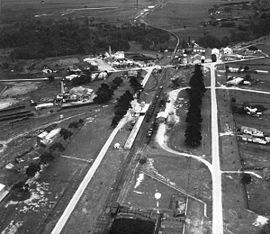
Maffra from the air, 1948
 Maffra
Population: 4,149 (2006)[1] Postcode: 3860 Elevation: 27 m (89 ft) Location: - 221 km (137 mi) from Melbourne
- 24 km (15 mi) from Sale
- 62 km (39 mi) from Bairnsdale
LGA: Shire of Wellington State District: Gippsland East Federal Division: Gippsland Mean max temp Mean min temp Annual rainfall 20.0 °C
68 °F8.1 °C
47 °F581.9 mm
22.9 inMaffra is a town in Victoria, Australia, 220 km east of Melbourne. It is in the Shire of Wellington local government area. It relies mainly on dairy farming and other agriculture,[2] and is the site of one of Murray-Goulburn Cooperative's eight processing plants in Victoria. Maffra is a detour off the Princes Highway and is near Sale, Stratford, Newry, Tinamba, Heyfield and Rosedale.[2] At the 2006 census, Maffra had a population of 4,149.[1]
Contents
History
The town began as an outstation of the region's first cattle run, Boisdale, named by pioneer grazier Lachlan Macalister after a village on the island of South Uist in the Outer Hebrides, Scotland. The town appears to have taken its name from a group of squatters from Maffra, a village in the Monaro region of NSW,[citation needed] with its location between current Maffra and Newry being written on an early map. The squatters moved on, but the name remained. The Monaro Maffra was probably connected to Mafra, a town in Portugal.[citation needed]
The township was settled in the 1860s, the Post Office opening on 20 July 1864.[3]
It was long the beef cattle capital of West Gippsland and, for many years, the only beet sugar processing centre in the country.[citation needed] The Beet Museum, set in the Port of Maffra Park, has relics from the defunct sugar beet industry. The building is a relocated historic weighbridge building, and is lined with pine boards from the home of Charles and Grace Quirk, one of Maffra's first cottages.[2]
Today
Maffra hosts a Mardi Gras in March, the Maffra and District Agricultural, Pastoral and Horticultural Show in October and a tennis tournament at Easter.
Maffra is considered to have one of the prettiest main streets (Johnson St) in Victoria. The Wellington Shire Council removed the 100+ year old trees that line it because of disease, but has since replaced them with young oaks.
Maffra has two primary schools, the Maffra Primary School and St Mary's Primary School (Catholic). Maffra also has a public secondary school, Maffra Secondary College, which has a student enrolment of around 700. Maffra Secondary has a strong academic program and is involved in a number of community service programs.
The Gippsland Vehicle Collection Motor Museum[4] is for lovers of old cars. It is housed in a huge old sugar beet building which the Car Club has cleaned and given new life.
A local group is working at Bellbird Corner, restoring the area to the popular picnic area it was in the 1900s.[2]
Sport
The town has an Australian Rules football team competing in the Gippsland Football League.[5]
Maffra is also home to a field hockey club, fielding junior, women's and men's teams in the East Gippsland Hockey Association.
Golfers play at the course of the Maffra Golf Club on Fulton Road.[6]
The under 14 Boys Maffra Basketball team reached the Australian National Championships in Darwin in 2008, for which they qualified by winning the Victoria Country state championships. They played in the Victorian Junior Basketball League (VJBL), the highest competition in Victoria for juniors.
The Maffra Football Seniors have won six premierships in the last seven years. They won three in a row, then lost in the 2004 Grand Final to Traralgon, then won another three.
Notable people
- Bill Bennett, AFL Player, member of Carlton's 1968 premiership side
- John Hipwell, Australian architect
References
- ^ a b "2006 Census QuickStats : Maffra (Urban Centre/Locality)". http://www.censusdata.abs.gov.au/ABSNavigation/prenav/LocationList?newgeography=Urban+Centre%2FLocality&level1=2&level2=UCL230200&submitbutton=View+QuickStats+%3E&mapdisplay=on&collection=Census&period=2006&areacode=2~UCL230200&geography=Urban+Centre%2FLocality&method=Place+of+Usual+Residence&productlabel=&producttype=QuickStats&topic=&navmapdisplayed=true&javascript=true&breadcrumb=PL&topholder=0&leftholder=0¤taction=102&action=401&textversion=false&subaction=2. Retrieved 2009-01-24.
- ^ a b c d "Maffra, Victoria - Towns in Australia". http://www.townsinaustralia.com/Maffra.1478.htm. Retrieved 2009-01-24.
- ^ Premier Postal History, Post Office List, https://www.premierpostal.com/cgi-bin/wsProd.sh/Viewpocdwrapper.p?SortBy=VIC&country=, retrieved 2008-04-11
- ^ Gippsland Vehicle Collection Motor Museum
- ^ Full Points Footy, West Gippsland Latrobe Football League, http://www.fullpointsfooty.net/West_Gippsland_Latrobe_football_league.htm, retrieved 2009-04-15[dead link]
- ^ Golf Select, Maffra, http://www.golfselect.com.au/armchair/courseView.aspx?course_id=1016, retrieved 2009-05-11
Coordinates: 37°57′S 146°59′E / 37.95°S 146.983°E
Towns in the Shire of Wellington Alberton • Alberton West • Boisdale • Briagolong • Bushy Park • Carrajung • Coongulla • Cowwarr • Dargo • Glenmaggie • Heyfield • Kilmany • Licola • Loch Sport • Longford • Maffra • Newry • Port Albert • Rosedale • Sale • Seaton • Stratford • Tinamba • Upper Maffra West • Valencia Creek • Woodside · Woodside Beach • Yarram
Categories:- Towns in Victoria (Australia)
- Gippsland


Wikimedia Foundation. 2010.