- Creag Mhòr
-
Creag Mhòr 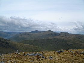
Creag Mhòr seen from the high ground to the SW. The Coire Chirdle landslip can be seen centre left.Elevation 1,047 m (3,435 ft) Prominence 393 m (1,289 ft) Listing Munro, Marilyn Translation Big Rock (Gaelic) Pronunciation Scottish Gaelic: [ˈkʰɾʲek ˈvoːɾ] Location Location Perth and Kinross / Stirling Council,  Scotland
Range Grampians Topo map OS Landranger 50, 51 OS Explorer 378 OS grid NN391360 Listed summits of Creag Mhòr Name Grid ref Height Status Stob nan Clach NN387351 956 m (3137 ft) Munro Top Creag Mhòr is a Scottish mountain which stands in the ancient Forest of Mamlorn deer forest, it is located ten kilometres north east of Tyndrum on the border between the Perth and Kinross and Stirling council areas.
Contents
Overview
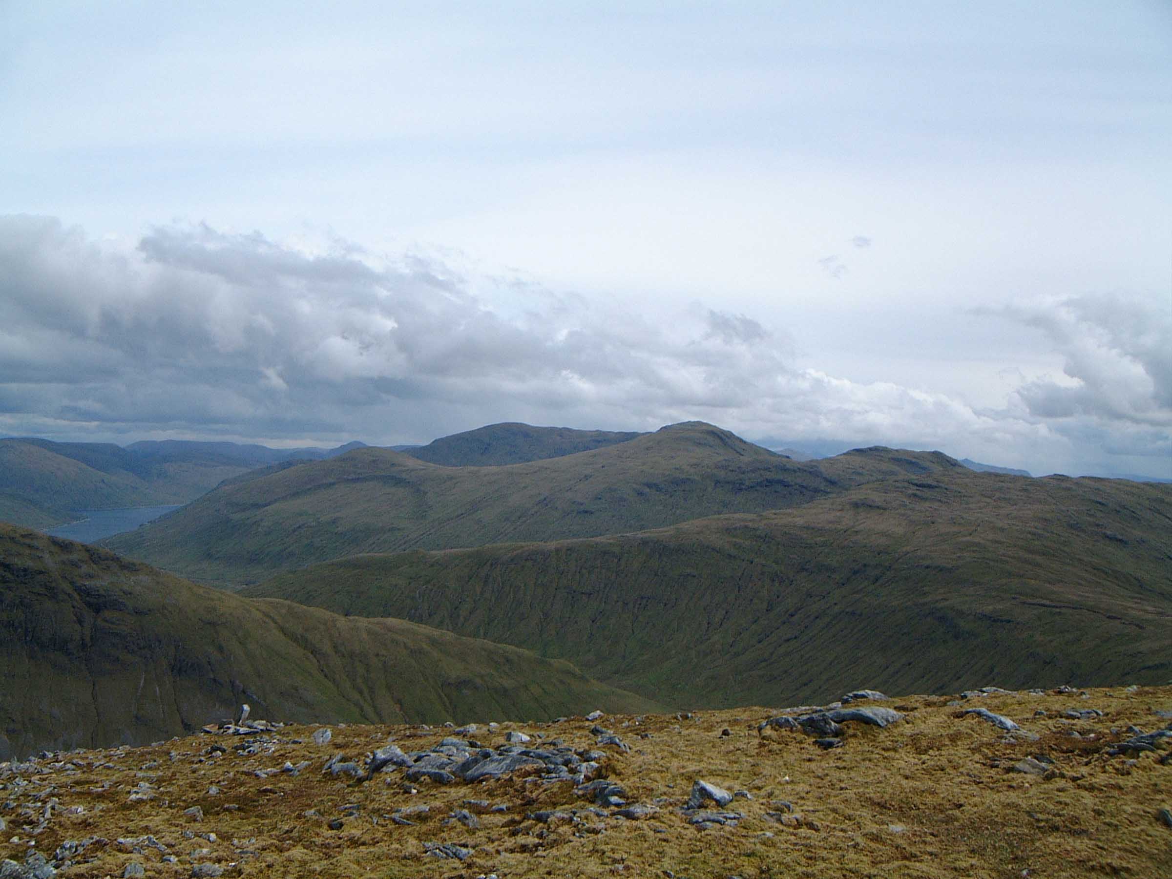
Creag Mhòr reaches a height of 1047 metres (3435 ft) and qualifies as a Munro and a Marilyn. It is commonly climbed with the neighbouring Munro of Beinn Heasgarnich, which stands 3.5 km to the NE, the two mountains form the high ground between Glen Lochay and Loch Lyon. Creag Mhòr is one of the remotest of the southern highlands[1] being situated about eight kilometres from the nearest public road, it is surrounded by other high ground which make it difficult to get a good view of the mountain from any valley, and the best aspect is obtained from the surrounding peaks. The mountains name translates from the Gaelic as “Big Rock”, an unusual name for a hill which is mostly grassy, however its top has craggy areas and the name refers to a series of rocky buttresses near the summit.[2]
Geography
Creag Mhòr is composed of three ridges, the ESE ridge (Sròn nan Eun) descends to Glen Lochay at the habitation of Batavaime and gives the usual route of ascent from that glen. Another ridge also descends to Glen Lochay, this initially goes south from the summit before swinging SE down steep slopes, which need care, to reach the glen. These two ridges enclose Coire Cheathaich (Misty Corrie), a former royal hunting ground which was made famous by Duncan Ban MacIntyre, the Scottish Gaelic poet who worked as a gamekeeper in the area. He wrote the poem Òran Coire a' Cheathaich (Song of the misty corrie) which gives a natural description of the corrie and its flora and fauna and includes the line "'S rìomhach còta na Creige Mòire" (lovely is the coat of Creag Mhòr).[3]
The south ridge includes the subsidiary summit of Stob nan Clach (956 m) which is listed as a top in the Munros Tables[4] and is reached from the main summit by contouring round the head of Coire Cheathaich for a kilometre. A third ridge on the mountain goes north over the 895 metre subsidiary top of Meall Tionail (Hill of the Gathering) before dropping down to Glen Lyon. This north ridge can be used for access to or from Beinn Heasgarnich, as the ridge can be left after a short distance and Heasgarnich can be reached by going east over the boggy Bealach na Baintighearna (654 m). All rainfall on Creag Mhòr drains to the east coast of Scotland at the Firth of Tay, either via Glen Lyon or Glen Lochay.
Meall Tionail has an unusual geographic feature on its western slopes, it is marked on OS maps as Coire Chirdle, however it is not a corrie in the usual sense as there is no hollow cavity in the mountain. Instead there is a clearly marked semi circle (see picture) called an arcuate scarp below which is a bulge. This was probably created after the last Ice Age when the unstable hillside saturated by meltwater slipped down the steep slope.[5] The nationally rare plant Bartsia Alpina grows on the slopes of Creag Mhòr, it is found as high as 950 metres, the highest occurrence in the U.K. It grows on brown loam soil on the mountains alkaline mica-schist rock.[6]
Ascents
Creag Mhòr is a rather isolated mountain and approaches require quite long walks to reach the foot of the hill. Ascents are possible from both the east and the west with the eastern approach from the road end in Glen Lochay being the most popular with guide book writers. This eastern approach starts at Kenknock (grid reference NN465364) which is now the farthest it is possible to drive up Glen Lochay with locked gates stopping cars from going any further, however it is viable to use a mountain bike. It is a six kilometre journey west up the glen to reach Batavaime at the foot of the SE ridge from where the mountain can be climbed.
The approach from the west starts at Auch (grid reference NN323354) on the A82 and goes under the viaduct of the West Highland Line, then SE up Glen Coralan and over the Corbett of Cam Chreag to reach Creag Mhòr. If continuing to Beinn Heasgarnich from the summit, a direct line NE is not recommended because the hillside is steep and rocky, instead use the north ridge as mentioned before heading east to the col between the two mountains to avoid dangerous ground.[7]
References
- The Munros, Scottish Mountaineering Trust, 1986, Donald Bennett (Editor) ISBN 0-0907521-13-4
- The High Mountains of Britain and Ireland, Diadem, 1993, Irvine Butterfield, ISBN 0-906371-30-9
- The Southern Highlands, SMC, 1991, Donald Bennett (Editor) ISBN 0-907521-34-7
- The Munros, Scotland's Highest Mountains, Cameron McNeish, ISBN 1-84204-082-0
- The Magic Of The Munros, Irvine Butterfield, ISBN 0-7153-2168-4
- Hamish’s Mountain Walk, Baton Wicks, 1996, Hamish Brown, ISBN 1-898573-08-5
Footnotes
- ^ "The Southern Highlands" Page 163 “Creag Mhor is one of the remotest mountains in the southern highlands“.
- ^ "The Magic of the Munros" Page 32 Gives translation and explanation.
- ^ www.slainte.org. Gives information on Duncan Ban Macintyre.
- ^ Online version of Munros Tables. Gives details of Stob nan Clach.
- ^ www.geotectonics.com. Gives details of Coire Chirdle Slide.
- ^ Biological Flora of the British Isles. Gives details of Bartsia Alpina.
- ^ "The Munros" Page 34 Gives routes of ascent.
 An Stùc · Beinn Achaladair · Beinn Challuim · Beinn a' Chreachain · Beinn Dòrain · Beinn an Dòthaidh · Beinn Ghlas · Beinn Heasgarnich · Ben Lawers · Beinn Mhanach · Càrn Gorm · Càrn Mairg · Creag Mhòr · Meall Corranaich · Meall nan Aighean · Meall Buidhe · Meall a' Choire Leith · Meall Ghaordaidh · Meall Garbh (Càrn Mairg Group) · Meall Garbh (Lawers Group) · Meall Glas · Meall Greigh · Meall nan Tarmachan · Schiehallion · Sgiath Chùil · Stuchd an Lochain
List of Munros Categories:- Munros
- Marilyns of Scotland
- Mountains and hills of the Southern Highlands


Wikimedia Foundation. 2010.